Goma International Airport
| Goma Airport | |||||||||||
|---|---|---|---|---|---|---|---|---|---|---|---|
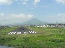 Mount Nyiragongo at the background | |||||||||||
| IATA: GOM – ICAO: FZNA | |||||||||||
| Summary | |||||||||||
| Airport type | Public | ||||||||||
| Operator | Government | ||||||||||
| Location | Goma, DR Congo | ||||||||||
| Elevation AMSL | 5,089 ft / 1,551 m | ||||||||||
| Coordinates | 01°40′11.6″S 29°14′17.8″E / 1.669889°S 29.238278°E | ||||||||||
| Map | |||||||||||
 GOM Location of Goma International Airport in DRC | |||||||||||
| Runways | |||||||||||
| |||||||||||
Goma International Airport (IATA: GOM, ICAO: FZNA) is an airport serving Goma, a city in the Democratic Republic of the Congo in Africa.
Airlines and destinations
| Airlines | Destinations |
|---|---|
| Congo Airways | Kindu, Kisangani, Kinshasa-N'djili[3] |
| Ethiopian Airlines | Addis Ababa[4] |
2002 Nyiragongo eruption
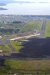
Initially built with a paved 3 km runway and a large terminal and apron, the airport has not recovered from the 2002 eruption of the volcano Nyiragongo, 14 km to the north. The airport couldn't handle any wide-bodied aircraft except for freight operations run by relief agencies and the United Nations. A stream of fluid lava 200 m by 1000 m wide flowed onto the runway and through the city center as far as the lake shore, covering over the northern 1 km of the runway and isolating the terminal and apron which were only connected by taxiway to the northern end. The lava can easily be seen in satellite photographs,[5] and aircraft can be seen using the 2 km southern section of the runway which is clear of lava. A temporary apron was made at the side of the operational part of the runway. A Douglas DC-8 was left stranded on the terminal apron, which is now used by commercial passengers and the military. In December 2012, a contractor began work on cleaning up and fencing in the airport.[6]
Accidents and incidents
- On 15 April 2008, 2008 Hewa Bora Airways crash, a Hewa Bora Airways McDonnell Douglas DC-9-51 (registration 9Q-CHN) overshot the runway during an aborted takeoff and crashed into the marketplace immediately to the south of the airport, killing 3 passengers and 37 people on ground.[7]
- On 19 November 2009, Compagnie Africaine d'Aviation Flight 3711, operated by McDonnell Douglas MD-82 (registration 9Q-CAB) bound from Kinshasa overran the runway on landing, suffering substantial damage.[8] The overrun area was contaminated by solidified lava.[9]
- On 12 February 2012, 2012 Katanga Express Gulfstream IV crash, a Gulfstream IV operated by Katanga Express registered as N2SA from Kinshasa overshot the runway and broke into two parts after touch down. Both pilots and two passengers were killed in the accident, as well as two farmers on ground. 8 other passengers were injured including Finance Minister Matata Ponyo, the governor of South Kivu, Marcelin Cishambo and Antoine Ghonda, former foreign minister of the D.R.C.[10]
- On 4 March 2013, 2013 Compagnie Africaine d'Aviation crash, a Compagnie Africaine d'Aviation Fokker 50 (registration 9Q-CBD) from Lodja crashed short of landing in heavy rain, into a residential area at 17:55 local time.[11][12][13] Among the 9 crew and passengers, 6 were killed.
See also
References
- ↑ Airport information for FZNA at World Aero Data. Data current as of October 2006.Source: DAFIF.
- ↑ Airport information for GOM at Great Circle Mapper. Source: DAFIF (effective October 2006).
- ↑ HORAIRE AVEC 1 Q400 DU 06/06 AU 10/07/2016 (Heures locales), http://www.congoairways.com/wp-content/uploads/2015/11/HORAIRE-1-Q400-2016-V2.0-ok.pdf
- ↑ "Ethiopian Airlines Delays Goma Launch to August 2015". Airline Route. 17 July 2015. Retrieved 17 July 2015.
- ↑ Google Earth has high resolution photographs showing the affected part of the airport at coordinates −1.658, 29.237. Retrieved 3 September 2007.
- ↑ "MONUSCO is building security fence around Goma airport" (Press release). MONUSCO. 12 January 2013. Retrieved 5 August 2016.
- ↑ "Accident description". Aviation Safety Network. Aviation Safety Network.
- ↑ David Kaminsky-Morrow (19 November 2009). "Congolese MD-82 badly damaged in Goma overrun". Flight Global.
- ↑ "Accident description". Aviation Safety Network. Retrieved 20 November 2009.
- ↑ "Accident description". Aviation Safety Network.
- ↑ "Dozens killed in DRC plane crash". News24. 4 March 2013.
- ↑ "RDC : un avion de la compagnie CAA s'est écrasé à Goma" (in French). Radio Okapi. 4 March 2013.
- ↑ "Plane crash in the city of Goma, MONUSCO comes to the rescue". MONUSCO. 5 March 2013. Retrieved 5 August 2016.
External links
| Wikimedia Commons has media related to Goma Airport. |