Gilmore Mills, Virginia
| Gilmore Mills, Virginia | |
|---|---|
| Unincorporated community | |
 Gilmore Mills, Virginia  Gilmore Mills, Virginia | |
| Coordinates: 37°36′31″N 79°32′29″W / 37.60861°N 79.54139°WCoordinates: 37°36′31″N 79°32′29″W / 37.60861°N 79.54139°W | |
| Country | United States |
| State | Virginia |
| County | Rockbridge |
| Elevation | 781 ft (238 m) |
| Time zone | Eastern (EST) (UTC-5) |
| • Summer (DST) | EDT (UTC-4) |
| Area code(s) | 276 |
| GNIS feature ID | 1492998[1] |
Gilmore Mills is an unincorporated community in Rockbridge County, Virginia, United States. Gilmore Mills is located on the James River 5.3 miles (8.5 km) west-southwest of Glasgow.
Annandale and the Varney's Falls Dam were listed on the National Register of Historic Places in 1993.[2]
References
- ↑ "Gilmore Mills". Geographic Names Information System. United States Geological Survey.
- ↑ National Park Service (2010-07-09). "National Register Information System". National Register of Historic Places. National Park Service.
Municipalities and communities of Rockbridge County, Virginia, United States | ||
|---|---|---|
| Towns | 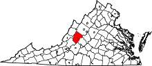 | |
| CDP | ||
| Unincorporated communities | ||
| Footnotes | ‡This populated place also has portions in an adjacent county or counties | |
This article is issued from Wikipedia - version of the 7/27/2016. The text is available under the Creative Commons Attribution/Share Alike but additional terms may apply for the media files.