Georgia State Route 400
| ||||
|---|---|---|---|---|
|
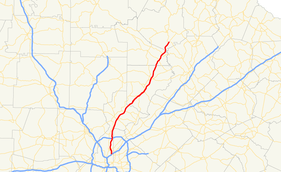
Map of northern Georgia with SR 400 highlighted in red | ||||
| Route information | ||||
| Maintained by GDOT | ||||
| Length: | 53.70 mi[1] (86.42 km) | |||
| Existed: | 1971, 1993 – present | |||
| Major junctions | ||||
| South end: |
| |||
|
| ||||
| North end: |
| |||
| Location | ||||
| Counties: | Fulton, Forsyth, Dawson, Lumpkin | |||
| Highway system | ||||
| ||||

Georgia state route 400 (officially "SR 400", nearly always Georgia 400 to the public) is a controlled-access state highway in the northern part of the U.S. state of Georgia. It is concurrent with U.S. Route 19 (US 19) from exit 4 (Interstate 285) until its terminus south-southeast of Dahlonega, linking the city of Atlanta to its north-central suburbs and exurbs. Georgia 400 travels from the Lindbergh neighborhood in the Buckhead district of Atlanta, at Interstate 85 (I-85), to just south-southeast of Dahlonega. Like the Interstate highways, it is a limited-access road (with interchanges instead of intersections), but unlike the interstates (which were renumbered by GDOT in 2000), the exit numbers are not mileage-based, they are sequential. Once Georgia 400 passes exit 17 (Georgia 306), it changes from a limited-access freeway into an at-grade divided highway with traffic lights, but still with a high speed limit of 65 miles per hour (105 km/h), and ends at the J.B. Jones Intersection at Georgia 60/Georgia 115 in Lumpkin County.
Between I-85 and I-285, Georgia 400 is designated "T. Harvey Mathis Parkway", after a local land developer and road proponent who died the day after being appointed as head of the Atlanta Committee for the Olympic Games in June 1991, when the tollway was under construction. Upon reaching the Perimeter (I-285) and beyond, the highway is designated "Turner McDonald Parkway". Georgia 400 is nicknamed locally as the "Alpharetta Autobahn" due to the prevalence of speeding.
Route description
Georgia State Route 400 begins at Interstate 85 just north of Downtown Atlanta, goes through Buckhead, then has a junction with Interstate 285 before heading north into the northern Atlanta suburbs. The freeway section ends at SR 306 and SR 400 continues as a surface road until reaching its end at US 19/SR 60/SR 115.[1]
All of SR 400 south of the Dawson–Lumpkin county line is included as part of the National Highway System, a system of roadways important to the nation's economy, defense, and mobility.[2]
Exits on SR 400 are numbered according to the consecutive numbering system instead of reference post (i.e. mile-based) numbering. This is unlike the Interstates in Georgia, which have used reference post numbering since 2000. This means that exit numbers on SR 400 start at 1 and use consecutive numbers (2, 3, 4, etc.) instead of the number of the nearest mile marker.
At the south terminus, new ramps connecting Georgia 400 south to Interstate 85 north and Interstate 85 south to Georgia 400 north opened on April 2, 2014.[3] The project was two years in the making and was paid for with funds from the Georgia 400 toll plaza. Prior, drivers had to exit off 400 onto Sidney Marcus Blvd. to get to I-85 north. On I-85 south, drivers had to take the Cheshire Bride Rd./Lenox Rd. exit to get to Sidney Marcus for access onto 400 north. The ramp from 85 south is shared with Georgia highway 13 ramp (exit 86). From 400, Sidney Marcus Blvd. is now exit 1B and the ramp to I-85 north is 1A.
In Forsyth County, GA 400 will expand from two lanes to three lanes from McFarland Pkwy to GA 369 (which is soon to be exit 18). This expansion is expected to be completed in October 2018.
History
Original portion (I-285 to Georgia 306)
Planning for the freeway, later known as the North Fulton Expressway, began in 1954.[4] The initial section north of I-285 was officially dedicated on May 24, 1971[5] and subsequent additions to the north opened in stages through 1981. The road was subsequently widened in 1989 from its original four-lane configuration to eight lanes between I-285 and Holcomb Bridge Road. The widening projects were brought on by the massive growth that the freeway brought to northern Fulton and southern Forsyth counties.
In December 2005, the Georgia Department of Transportation began widening the section from Holcomb Bridge Road to Windward Parkway from three to four lanes in the northbound direction and from two to four lanes from Windward Parkway to McFarland Parkway. Southbound, the highway was being widened to four lanes between McFarland Parkway and Holcomb Bridge Road. In addition, metal noise barrier walls and a concrete divider in the median were also added. Unlike the tollway section, no space was left for future extension of MARTA rail lines, despite there being no other adjacent rail corridor as most of the region's other areas have, and the fact that north Fulton is the only large densely populated area within MARTA's district remaining without rail service.
In 2010, a half-diamond interchange (exit 4C) was added on the north side of Hammond Drive, allowing southbound exits and northbound entrances.
Tollway extension (I-85 to I-285)


The southern section of the highway (from I-285 to I-85) was the last section to be constructed. It was the only active toll road in Georgia, after the Torras Causeway toll between Brunswick and St. Simons Island on the southeastern Georgia coast was removed in 2003,[6] until the high occupancy toll express lanes opened on I-85 in 2011. The Georgia 400 toll was to expire in 2011 after 20 years. However, Sonny Perdue and members of the State Road and Tollway Authority (SRTA) voted on September 24, 2010 to keep the tolls on until 2020. The 10-year extension was to fund 11 new projects on the highway.[7]
Despite the above vote, the tolls were removed in November 2013 by Governor Nathan Deal as part of a campaign promise to the residents of north Fulton and Forsyth counties.[8] In 2014 the toll booths were demolished.[9]
Freeway revolt
At one time, Georgia 400 was to connect to Interstate 675 in southeast DeKalb county. However, residents in intown Atlanta neighborhoods did not want the highway to cut through and partially destroy their neighborhoods (as had occurred in the Sweet Auburn and other neighborhoods), and a freeway revolt ensued, ending when then-Governor Jimmy Carter signed a new city charter and the USDOT rejected the highway studies in 1973, and George Busbee had the plan officially terminated when he became governor in 1975. The point where this road would have had its interchange with the also-doomed Interstate 485 (now Freedom Parkway and Georgia 10 to Stone Mountain Freeway) is now the site of the Jimmy Carter Library and Museum. A later routing of I-485 would have had that number running from the Downtown Connector west to the current library, then north on what is now Georgia 400.
The northern portion of the inside-the-Perimeter route remained alive, and after lawsuits by residents that spent several years in court, GDOT was able to force the extension through Buckhead. Dozens of homes were taken through eminent domain or the threat of it, and the highway was built though the middle of formerly-secluded and forested neighborhoods. Some remaining residents live on dead end streets with metal barrier walls.
The road opened to traffic on August 1, 1993, after three years of construction, including under a large office building constructed in 1984 to accommodate it. Existing exits were renumbered up by four to accommodate the extension, which had a single toll plaza in the middle of its length when opened. Contrary to public belief, the bonds that funded the construction of the tollway south of I-285 were not paid off until 2011.
Direct access from Georgia 400 southbound to I-85 northbound (and the reverse direction) opened in April 2014, ending the need to take the indirect route via Sidney Marcus Boulevard. In June 2015, a ceremony was held to name the flyover bridges for Captain Herb Emory, a beloved local traffic reporter for WSB AM and WSB-TV (as well as other co-owned stations) who had also died in April 2014.[10]
In addition, the North Line (now Red Line) for Atlanta's MARTA train system was constructed in the median from the Glenridge Connector to south of Lenox Road, and was opened on June 8, 1996, extending the line from Lenox Square mall north to Perimeter Mall, and connecting the Perimeter Center area to the rail system. That edge city largely developed due to its proximity to the 400/285 interchange.
When Georgia 400 was a toll road, the toll plaza, operated by the State Road and Tollway Authority (SRTA), collected 50¢ tolls in both the northbound and southbound directions. Each direction had two open-road toll lanes, which collected tolls at highway speeds using the Georgia Peach Pass electronic tag (formerly "Cruise Card"), and seven gated toll lanes that accepted cash. The toll facility handled a total of approximately 120,000 vehicles per day. About 37% of transactions were paid via Peach Pass, the same technology also used by SunPass in Florida, QuickPass in North Carolina, TxTag in Texas, and PikePass in Oklahoma. Peach Pass can be used interchangeably with the Florida and North Carolina systems and passes, but not with TxTag and PikePass, due to a lack of reciprocal billing arrangements with those non-adjacent states.
In March 2009, local TV news reports brought up an issue regarding tolls on the road, since SRTA reported that enough money has been collected to pay the bonds used to construct the road (though prepayment prior to 2011 was prohibited). Despite promises that the toll would be removed once the road was paid for, the tolls continued to be collected. The road costs $2 million per year just to maintain (plus occasional repaving), and it cost several million more for the demolition of the toll plaza. (One option would have been to simply close the toll plaza, allowing drivers to pass through without paying.) Without the revenue from it, the state must raise money through taxes for new road projects, such as the reconstruction of the interchange at I-285, expected to cost $2 billion. On July 19, 2012, Governor Nathan Deal announced that despite this, the toll barrier would be removed by the end of 2013.[11] Originally scheduled for the end of November, it was advanced to the weekend before the heavy travel of the Thanksgiving holiday.
A revival of the connection to I-675 was proposed in 2009. A tunnel would go under East Atlanta and other neighborhoods in Atlanta on the DeKalb-county side, south to I-20. A surface road through less-developed land would then go south to I-675. The project would be a public/private initiative.
Tolls
Tolling was discontinued on November 22, 2013 at 11:08 am; the last toll was collected by Governor Nathan Deal and was paid by the same couple that paid the first toll in 1993. The toll plaza was removed in a four-phase demolition project.[12]
The toll plaza was located north of Lenox Road (Exit 2). Tolls were formerly collected in both directions. The toll was $0.50 for a two-axle vehicle, $1.50 for three axles, plus $0.50 for each additional axle. In July 2012, two weeks before voters of Georgia voted on the Transportation Referendum act, Governor Deal said that the toll on GA 400 would be abandoned in November 2013, meaning that, at the beginning of 2014, SR 400 would be a toll-free road.
In 2012, a feasibility study was initiated by the Georgia Department of Transportation to explore the possibility of adding tolled express lanes.[13] The proposed express lanes would be 24 miles (39 km) long, and mirror the existing lanes on Interstate 85. The lanes' southern terminus will be Interstate 285 in Sandy Springs, and their northern terminus would be SR 20 in Cumming. Fees would be similar to the existing I-85 lanes, and will be paid using Peach Pass, making the express lanes compatible with the existing express lanes on I-85 (as well as the former toll plaza in Buckhead if it had remained in operation).
Movie filming
Several scenes from the movie Smokey and the Bandit were filmed on Georgia 400. The "Alabama" police chase where the Bandit hides in a convoy of trucks actually takes place on Georgia 400 between exit 12 and exit 14 in Cumming.
Exit list
| County | Location | mi[1] | km | Exit | Destinations | Notes |
|---|---|---|---|---|---|---|
| Fulton | Atlanta | 0.0 | 0.0 | — | Southern terminus | |
| 0.6 | 0.97 | 1B | Sidney Marcus Boulevard | Southbound exit and northbound entrance only | ||
| 2.8 | 4.5 | 2 | Single-point urban interchange | |||
| Toll plaza (demolished 2014) | ||||||
| Sandy Springs | 6.6 | 10.6 | 3 | Glenridge Perimeter Connector | Northbound exit via exit 4A; former SR 407 Loop | |
| 6.8 | 10.9 | 4 | Southern end of US 19 concurrency; signed as exits 4A (east) and 4B (west) | |||
| 7.4 | 11.9 | 4C | Hammond Drive – Dunwoody, Sandy Springs | Southbound exit and northbound entrance only | ||
| 8.4 | 13.5 | 5 | Abernathy Road – Dunwoody, Sandy Springs | Northbound exits signed as exits 5A (east) and 5B (west) | ||
| 10.0 | 16.1 | 5C | Southbound exit and northbound entrance only | |||
| 12.0 | 19.3 | 6 | Northridge Road | |||
| Roswell | 15.0 | 24.1 | 7 | Northbound exit signed as exits 7A (east) and 7B (west) | ||
| Alpharetta | 16.4 | 26.4 | 8 | Mansell Road | ||
| 18.3 | 29.5 | 9 | Haynes Bridge Road | |||
| 19.6 | 31.5 | 10 | ||||
| 21.0 | 33.8 | 11 | Windward Parkway | |||
| Forsyth | | 22.4 | 36.0 | 11B | McGinnis Ferry Rd | Exit currently being constructed |
| 23.8 | 38.3 | 12 | McFarland Parkway | Northbound exit signed as exits 12A (east) and 12B (west) | ||
| 28 | 45 | 13 | ||||
| 30.8 | 49.6 | 14 | Northbound exit signed as exits 14A (east) and 14B (west) | |||
| Cumming | 32.8 | 52.8 | 15 | Bald Ridge Marina Road | ||
| | 34.7 | 55.8 | 16 | Pilgrim Mill Road | ||
| 36.3 | 58.4 | 17 | ||||
| 37.2 | 59.9 | 18 | 2018 expected completion for conversion from intersection to interchange | |||
| | North end of freeway | |||||
| Dawson | Dawsonville | 44.9 | 72.3 | |||
| | 47.8 | 76.9 | ||||
| Lumpkin | | 53.7 | 86.4 | Northern terminus; northern end of US 19 concurrency | ||
1.000 mi = 1.609 km; 1.000 km = 0.621 mi
| ||||||
See also
-
.svg.png) Georgia (U.S. state) portal
Georgia (U.S. state) portal -
 Atlanta portal
 -
 U.S. Roads portal
 - Transportation in Atlanta
Notes
References
- 1 2 3 Google (October 31, 2012). "GA-400" (Map). Google Maps. Google. Retrieved October 31, 2012.
- ↑ "National Highway System: Atlanta, GA" (PDF). United States Department of Transportation. October 1, 2012. Retrieved September 14, 2013.
- ↑ http://www.ajc.com/gallery/news/flyover-ramp-connecting-400-85-opens/gCJyY/#4856237
- ↑ "Historic Preservation Element" (PDF). November 7, 2005. Retrieved September 14, 2013.
- ↑ Walsh, Darlene M., ed. (1994). Roswell: A Pictorial History (2nd ed.). p. 150. ISBN 0-9615854-2-0.
- ↑ "Governor Perdue and Georgia DOT Announce Elimination of Torras Causeway Toll" (Press release). September 12, 2003. Retrieved September 14, 2013.
- ↑ "Ga. 400 Toll Will Remain Until 2020". Atlanta, GA: WSB-TV. September 24, 2010. Retrieved September 14, 2013.
- ↑ http://www.georgiatolls.com/programs/ga-400/
- ↑ http://www.peachpass.com/peach-pass-toll-facilities/about-ga400
- ↑ http://www.wsbtv.com/news/local/ga-400-flyover-renamed-capt-herb-emory/33427589
- ↑ "Governor to remove Ga. 400 toll barriers". Atlanta, GA: WSB-TV. July 19, 2012. Retrieved July 19, 2012.
- ↑ Parrish, Sandra (November 22, 2013). "Deal fulfills promise to end tolls on GA 400". WSB Radio. Retrieved November 22, 2013.
- ↑ "GA 400 Express Lanes". Georgia Department of Transportation. Retrieved September 14, 2013.
External links
-
 Media related to Georgia State Route 400 at Wikimedia Commons
 - Georgia State Route 400 on State-Ends.com
- State Road and Tollway Authority homepage
- Peach Pass