Georgia State Route 141
| ||||
|---|---|---|---|---|
 | ||||
| Route information | ||||
| Maintained by GDOT | ||||
| Length: | 28.0 mi[1] (45.1 km) | |||
| Major junctions | ||||
| South end: |
| |||
|
| ||||
| North end: |
| |||
| Location | ||||
| Counties: | Fulton, DeKalb, Gwinnett, Forsyth | |||
| Highway system | ||||
| ||||

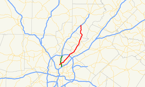
State Route 141 (SR 141) is a 28.0-mile-long (45.1 km) state highway that runs southwest-to-northeast in the northwest part of the U.S. state of Georgia. It connects the Buckhead area of Atlanta with Cumming. Its routing exists within portions of Fulton, DeKalb, Gwinnett, Forsyth counties.
Route description

SR 141 begins at an intersection with US 19/SR 9 (Roswell Road NE) in the Buckhead neighborhood of Atlanta, in Fulton County. It travels to the northeast to an intersection with SR 237 (Piedmont Road NE). Just after that intersection, it goes over, but does not have an interchange with SR 400 (T. Harvey Mathis Parkway). Immediately after is the southern terminus of SR 141 Connector (Lenox Road NE). The highway passes just northwest of the Buckhead Heights neighborhood, crosses into DeKalb County, and passes through Brookhaven. SR 141 passes Oglethorpe University and the Peachtree Golf Club, just before passing through Chamblee. In Doraville, it has an intersection with SR 13 Connector and an interchange with Interstate 285 (I-285). The road becomes a freeway on the northeast of the interchange, served by a pair of one-way frontage roads with "Texas U-turns"; it has a few exits along its length. It enters Gwinnett County near the middle of the freeway; near the end of the freeway is SR 140. It passes through Peachtree Corners. Then, it crosses over the Chattahoochee River back into Fulton County. It travels through Johns Creek and meets SR 120 (Abbotts Bridge Road). Northeast of there, it enters Forsyth County. The roadway curves to the northwest and then to the north. It has an interchange with US 19/SR 400 (Hospitality Highway), southwest of Cumming. Just after this interchange, it meets its northern terminus, an intersection with SR 9 (Atlanta Highway).[1]
All of SR 141 from its southern terminus in Buckhead to a point southwest of Duluth is part of the National Highway System, a system of roadways important to the nation's economy, defense, and mobility.[2]
Major intersections
| County | Location | mi[1] | km | Destinations | Notes |
|---|---|---|---|---|---|
| Fulton | Atlanta | 0.0 | 0.0 | Southern terminus | |
| 0.6 | 0.97 | ||||
| 1.3 | 2.1 | Southern terminus of SR 141 Connector | |||
| DeKalb | Doraville | 7.6 | 12.2 | I-285, exit 31; Start of the Freeway | |
| Gwinnett | Peachtree Corners | 11.2 | 18.0 | end of Freeway | |
| Fulton | Johns Creek | 19.5 | 31.4 | ||
| Forsyth | | 27.7 | 44.6 | ||
| | 28.0 | 45.1 | Northern terminus | ||
| 1.000 mi = 1.609 km; 1.000 km = 0.621 mi | |||||
Related routes
| |
|---|---|
| Location: | Buckhead, Atlanta |
| Length: | 0.9 mi[3] (1.4 km) |
State Route 141 Connector (SR 141 Connector) exists entirely within the Buckhead section of Atlanta, in eastern Fulton County. It is known as Lenox Road NE for its entire length.
It begins at an intersection with the SR 141 mainline (Peachtree Road NE) just northwest of the Buckhead Heights neighborhood of Atlanta. The highway heads northwest, curves to the west-southwest underneath, but does not have an interchange with, SR 400 (T. Harvey Mathis Parkway). It curves to the southwest to meet its northern terminus, an intersection with SR 237 (Piedmont Road NE), at the Buckhead Forest neighborhood of Atlanta.[3]
SR 141 Connector is not part of the National Highway System, a system of roadways important to the nation's economy, defense, and mobility.[2]
The entire route is in Atlanta, Fulton County.
| mi[1] | km | Destinations | Notes | ||
|---|---|---|---|---|---|
| 0.0 | 0.0 | Southern terminus | |||
| 0.9 | 1.4 | Northern terminus | |||
| 1.000 mi = 1.609 km; 1.000 km = 0.621 mi | |||||
Another State Route 141 Connector (SR 141 Connector) exists entirely within Gwinnett County in Peachtree Corners and consists of the access roads on both sides of Peachtree Industrial Boulevard between Holcomb Bridge Rd. and Jimmy Carter Boulevard (SR 140).
Peachtree Industrial Boulevard is a road in the U.S. state of Georgia that runs from just north of Chamblee, and ends in Buford. For approximately four-fifths of its length, Peachtree Industrial Boulevard is not coextensive with SR 141. The section between I-285 and SR 140 (Jimmy Carter Boulevard) and overlapping SR 141 in Norcross is a freeway. North of SR 140, Peachtree Industrial Boulevard splits from SR 141 and continues to the northeast as a 4+ lane highway with center median, passing through the cities of Peachtree Corners, Duluth, Suwanee, Sugar Hill, and Buford. This portion is maintained by Gwinnett County.[4][5] In the future, the county plans a grade-separation upgrade for the portion between the SR 141 split and Sugarloaf Parkway.[6]
Orphaned Segments
There are six road segments that previously carried State Road 141 or a derivative designation that no longer do.
- What is now Georgia SR 371 once was SR 141 between Georgia SR 9 and SR 20. It was changed to its present number in the early 1970s.
- The State Road 141 designation was previously used in DeKalb County between Tucker and US 78 in what is now Stone Mountain Park on what is now Hugh Howell Highway (SR 236) which was at the time named Rosser Road.[7]
- Prior to construction of Peachtree Parkway and the extension and re-routing of SR141 to Buckhead, SR 141 followed what is present day Medlock Bridge Road from its current intersection with Peachtree Parkway, into downtown Norcross and became North Peachtree Road, crossed the railroad tracks at Park Street, and then traveled on South Peachtree until its terminus at Buford Highway (SR13). When plans were drawn to re-route SR 141 to its present alignment, GDOT changed the designation of this roadway to SR141 Connector. This designation stayed in effect until 1981, when this segment was turned over to the county and converted to local roads.[8] What is now SR 141 between the Buckhead junction with Roswell Rd. (SR9) and Motors Industrial Way (Present day SR 13 Connector) was designated along with Motors Industrial Way as SR 13W before it was made part of the newly aligned SR 141
- With the construction of Interstate 85, Norcross Tucker road, which at the time was a contiguous road, was designated SR 141 Connector, and the small segment of South Peachtree Road between Buford Highway and Norcross Tucker Road was redesigned SR 141 Spur. The South Peachtree Road (SR141 Spur) was converted to a local road in 1981 along with truncation of SR141 Connector to Norcross Tucker Road between South Peachtree Rd in Norcross and Interstate 85.
- As Jimmy Carter Boulevard was constructed in the 1970s, Norcross Tucker Road was split into North Norcross Tucker Road and South Norcross Tucker Road, and a portion of the road was incorporated into Jimmy Carter Boulevard. In 1981, Jimmy Carter Boulevard was designated as SR 141 Connector between Peachtree Industrial Boulevard and Interstate 85.[9] It was converted to State Road 140 in 1984-1985 timeframe[10] and the SR141 Connector designation was used for what is present day SR141 Connector at the 141/Peachtree Industrial Boulevard interchange when the Jimmy Carter Boulevard/SR141 intersection was upgraded to a grade separated intersection.
- The 17.5 mile segment of State Road 369 East of SR 9 from North of Cumming to Gainesville was designated as SR 141 until 1970, when it was extended West to SR 20, and redesigned to its present-day number.[11][12]
See also
-
.svg.png) Georgia (U.S. state) portal
Georgia (U.S. state) portal -
 Atlanta portal
 -
 U.S. Roads portal
 - Peachtree Road
- Transportation in Atlanta
References
- 1 2 3 4 Google (June 28, 2013). "Route of SR 141" (Map). Google Maps. Google. Retrieved June 28, 2013.
- 1 2 "National Highway System: Georgia" (PDF). United States Department of Transportation. October 1, 2012. Retrieved June 28, 2013.
- 1 2 Google (June 28, 2013). "Route of SR 141 Connector" (Map). Google Maps. Google. Retrieved June 28, 2013.
- ↑ "Street Maintenance". City of Duluth. Retrieved December 29, 2013.
- ↑ "City of Suwanee City Services". City of Suwanee. Retrieved December 29, 2013.
- ↑ "Gwinnett County Comprehensive Transportation Plan" (PDF). Gwinnett County. Retrieved December 29, 2013.
- ↑ "Georgia DOT Map Archive, DeKalb County 1900's, 1948 Map". Retrieved 2016-06-22.
- ↑ "Georgia DOT Map Archive - Gwinnett County 1900's". Retrieved 2016-06-22.
- ↑ "Georgia DOT Map Archive - Gwinnett County 1900's". Retrieved 2016-06-22.
- ↑ "GDOT State Highway Map 1984-1985" (PDF). Retrieved 2016-06-22.
- ↑ "1970 State Highway Map GDOT" (PDF).
- ↑ "1971 State Highway Map GDOT" (PDF).