Geographic regions of Greece
 |
| This article is part of a series on the politics and government of Greece |
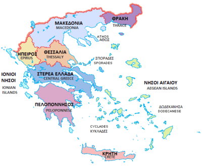
The traditional geographic regions of Greece (Greek: γεωγραφικά διαμερίσματα, literally "geographic departments") are the country's main historical-geographic regions, and were also official administrative regional subdivisions of Greece until the 1987 administrative reform.[1] Despite their replacement as first-level administrative units by the newly defined administrative regions (Greek: περιφέρειες), the nine traditional geographic divisions—six on the mainland and three island groups—are still widely referred to in unofficial contexts and in daily discourse.
As of 2011, the official administrative divisions of Greece consist of 13 regions (Greek: περιφέρειες)—nine on the mainland and four island groups—which are further subdivided into 74 regional units and 325 municipalities. Formerly, there were also 54 prefectures or prefectural-level administrations.
|
The regions shown on the map but not in the list are geographic regions, but they are not major. |
 |
See also
Notes
- ↑ Π.Δ. 51/87 “Καθορισμός των Περιφερειών της Χώρας για το σχεδιασμό κ.λ.π. της Περιφερειακής Ανάπτυξης” (Determination of the Regions of the Country for the planning etc. of regional development, ΦΕΚ A 26/06.03.1987
- ↑ In Macedonia there is one autonomous region, Mount Athos (Ayion Oros, or "Holy Mountain"), a monastic state under Greek sovereignty. It is located on the easternmost of the three large peninsulas jutting into the Aegean from the Macedonian mainland.
Greece articles | ||||||||
|---|---|---|---|---|---|---|---|---|
| History |
| | ||||||
| Geography |
| |||||||
| Politics | ||||||||
| Economy | ||||||||
| Society | ||||||||
| ||||||||