Friendsville, Pennsylvania
| Friendsville, Pennsylvania | |
|---|---|
| Borough | |
 Friendsville, Pennsylvania | |
| Coordinates: 41°55′05″N 76°02′49″W / 41.91806°N 76.04694°WCoordinates: 41°55′05″N 76°02′49″W / 41.91806°N 76.04694°W | |
| Country | United States |
| State | Pennsylvania |
| County | Susquehanna |
| Settled | 1819 |
| Incorporated | 1847 |
| Area | |
| • Total | 1.5 sq mi (3.8 km2) |
| Population (2010) | |
| • Total | 111 |
| • Density | 74/sq mi (28.9/km2) |
| Time zone | Eastern (EST) (UTC-5) |
| • Summer (DST) | EDT (UTC-4) |
| Zip code | 18818 |
| Area code(s) | 570 |
Friendsville is a borough in Susquehanna County, Pennsylvania, United States. The population was 111 at the 2010 census. The community was named for the colony of Quakers settling here.
Geography
Friendsville is located at 41°55′5″N 76°2′49″W / 41.91806°N 76.04694°W (41.917987, -76.046952).[1]
According to the United States Census Bureau, the borough has a total area of 1.5 square miles (3.9 km2), all of it land.
Demographics
| Historical population | |||
|---|---|---|---|
| Census | Pop. | %± | |
| 1850 | 185 | — | |
| 1860 | 202 | 9.2% | |
| 1870 | 223 | 10.4% | |
| 1880 | 176 | −21.1% | |
| 1890 | 139 | −21.0% | |
| 1900 | 110 | −20.9% | |
| 1910 | 103 | −6.4% | |
| 1920 | 74 | −28.2% | |
| 1930 | 74 | 0.0% | |
| 1940 | 76 | 2.7% | |
| 1950 | 65 | −14.5% | |
| 1960 | 60 | −7.7% | |
| 1970 | 77 | 28.3% | |
| 1980 | 72 | −6.5% | |
| 1990 | 102 | 41.7% | |
| 2000 | 91 | −10.8% | |
| 2010 | 111 | 22.0% | |
| Est. 2015 | 106 | [2] | −4.5% |
| Sources:[3][4][5] | |||
2010 census
As of the census[6] of 2010, there were 111 people, 44 households, and 29 families residing in the borough. The population density was 74 people per square mile (28.9/km²). There were 54 housing units at an average density of 36 per square mile (14.1/km²). The racial makeup of the borough was 91.9% White, 6.3% Black, and 1.8% Native American.
There were 44 households out of which 31.8% had children under the age of 18 living with them, 52.3% were married couples living together, 11.4% had a female householder with no husband present, and 34.1% were non-families. 22.7% of all households were made up of individuals and 11.4% had someone living alone who was 65 years of age or older. The average household size was 2.52 and the average family size was 2.97.
In the borough the population was spread out with 27.9% under the age of 18, 55% from 18 to 64, and 17.1% who were 65 years of age or older. The median age was 42.5 years.
The median income for a household in the borough was $35,625, and the median income for a family was $51,250. Males had a median income of $29,464 versus $37,917 for females. The per capita income for the borough was $15,996. There were 15.6% of families and 9.6% of the population living below the poverty line, including 7.9% of under 18 and none of those over 65.
2000 census
As of the census[4] of 2000, there were 91 people, 38 households, and 25 families residing in the borough. The population density was 62.0 people per square mile (23.9/km²). There were 45 housing units at an average density of 30.7 per square mile (11.8/km²). The racial makeup of the borough was 100.00% White.
There were 38 households out of which 26.3% had children under the age of 18 living with them, 55.3% were married couples living together, 7.9% had a female householder with no husband present, and 34.2% were non-families. 23.7% of all households were made up of individuals and 5.3% had someone living alone who was 65 years of age or older. The average household size was 2.39 and the average family size was 2.88.
In the borough the population was spread out with 23.1% under the age of 18, 6.6% from 18 to 24, 26.4% from 25 to 44, 31.9% from 45 to 64, and 12.1% who were 65 years of age or older. The median age was 42 years. For every 100 females there were 106.8 males. For every 100 females age 18 and over, there were 94.4 males.
The median income for a household in the borough was $53,125, and the median income for a family was $53,750. Males had a median income of $31,250 versus $24,375 for females. The per capita income for the borough was $18,502. There were 9.4% of families and 6.8% of the population living below the poverty line, including 9.4% of under eighteens and none of those over 64.
References
- ↑ "US Gazetteer files: 2010, 2000, and 1990". United States Census Bureau. 2011-02-12. Retrieved 2011-04-23.
- ↑ "Annual Estimates of the Resident Population for Incorporated Places: April 1, 2010 to July 1, 2015". Retrieved July 2, 2016.
- ↑ "Census of Population and Housing". U.S. Census Bureau. Retrieved 11 December 2013.
- 1 2 "American FactFinder". United States Census Bureau. Retrieved 2008-01-31.
- ↑ "Incorporated Places and Minor Civil Divisions Datasets: Subcounty Resident Population Estimates: April 1, 2010 to July 1, 2012". Population Estimates. U.S. Census Bureau. Retrieved 11 December 2013.
- ↑ "American FactFinder". United States Census Bureau. Retrieved 2011-05-14.
Municipalities and communities of Susquehanna County, Pennsylvania, United States | ||
|---|---|---|
| Boroughs | 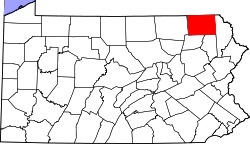 | |
| Townships | ||
| Unincorporated community | ||