Franklin, Alabama
| Franklin, Alabama | |
|---|---|
| Town | |
|
Franklin Volunteer Fire Department and Town Hall | |
 Location in Macon County and the state of Alabama | |
| Coordinates: 32°27′19″N 85°48′10″W / 32.45528°N 85.80278°W | |
| Country | United States |
| State | Alabama |
| County | Macon |
| Government | |
| • Type |
Mayor Bobby Perry 1976-1979 Mayor Rufus Carson 1979-2012 Mayor Alvin G Sears 2012-2016 Mayor Henry Peavy 2016-Present |
| Area | |
| • Total | 3.3 sq mi (8.7 km2) |
| • Land | 3.3 sq mi (8.7 km2) |
| • Water | 0 sq mi (0 km2) |
| Elevation | 220 ft (67 m) |
| Population (2010) | |
| • Total | 149 |
| • Density | 43/sq mi (17/km2) |
| Time zone | Central (CST) (UTC-6) |
| • Summer (DST) | CDT (UTC-5) |
| FIPS code | 01-28024 |
| GNIS feature ID | 0156379 |

Franklin is a town in Macon County, Alabama, United States. The 2010 census placed the population at 149, unchanged from 2000.
History and Educational Legacy
Franklin School was in operation as early as the 1890s teaching grades 1–11. By the mid-1930s it was downsized to grades 1-6. There were northern and southern classrooms adjoined by a common auditorium. The school's original water source was a spring near the buildings. A well was later dug in the front yard of the school, with a hand pump that provided the water. Heat was provided by a wood-burning potbelly stove. Each student brought a stick of wood every morning for use in the stove. The school closed in 1942, and its 75–80 students transferred to Tuskegee schools. After the close of the school the northern classroom was moved to its current location, converted to a community center. The rest of the school was torn down.[1]
During its use as a community center, Hank Williams Sr. often performed for dances. Upon Franklin's 1977 incorporation, the town began using the building as the town hall. A mile north of Town Hall lay the remnants of what is rumored to be the first school in Macon County.[1]
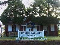
Located at the corner of Co. Rd. 27 and 36 and restored as a historic museum, Harris Barrett School was built in 1903 with handmade bricks made by Tuskegee Normal School (now Tuskegee University) students under the direction of Booker T. Washington. For many years, it was an education center for slave descendants in the area. Both Harris Barrett and Tuskegee Institute played a major role in education in the Franklin community. There was an experimental farm on the west side of Baldwin Farm Road. Booker T. Washington and George Washington Carver were both active in farming in Franklin, assisting farmers both black and white. Many farms in Franklin were cleared by the Creek Indians. Well known Native American leader Osceola was born on Red Creek, 10 miles from the Tallapoosa River.[1]
Franklin has been home to many churches for over 200 years, including, in the late 18th and early 19th centuries, a Methodist Missionary Church for the Creek Indians with two cemeteries, one for white burial and another for Indian burial. James McQueen, great-grandfather of Osceola, is buried in the Indian cemetery.[1]
Geography
Franklin is located at 32°27′19″N 85°48′10″W / 32.45528°N 85.80278°W (32.455388, -85.802884).[2]
According to the U.S. Census Bureau, the town has a total area of 3.34 square miles (8.7 km2), all land.
Demographics
| Historical population | |||
|---|---|---|---|
| Census | Pop. | %± | |
| 1970 | 173 | — | |
| 1980 | 133 | −23.1% | |
| 1990 | 152 | 14.3% | |
| 2000 | 149 | −2.0% | |
| 2010 | 149 | 0.0% | |
| Est. 2015 | 132 | [3] | −11.4% |
| U.S. Decennial Census[4] 2013 Estimate[5] | |||
As of the census[6] of 2000, there were 145 people, 59 households, and 44 families residing in the town. The population density was 43 people per square mile (17.2/km²). There were 73 housing units at an average density of 18.0 per square mile (8.9/km²). The racial makeup of the town was 56.38% Black or African American and 43.62% White. 0.67% of the population were Hispanic or Latino of any race.
There were 59 households, of which 28.1% had children under the age of 18 living with them, 51.6% were married couples living together, 15.6% had a female householder with no husband present, and 25.0% were non-families. 21.9% of all households were made up of individuals and 10.9% had someone living alone who was 65 years of age or older. The average household size was 2.33 and the average family size was 2.69.
In the town the population was spread out with 20.1% under the age of 18, 10.7% from 18 to 24, 18.1% from 25 to 44, 33.6% from 45 to 64, and 17.4% who were 65 years of age or older. The median age was 47 years. For every 100 females there were 96.1 males. For every 100 females age 18 and over, there were 88.9 males.
The median income for a household in the town was $45,923, and the median income for a family was $53,111. Males had a median income of $43,840 versus $40,744 for females. The per capita income for the town was $45,495. 4.9% of the population were living below the poverty line. 9.7% of those were over the age of 64.
References
- 1 2 3 4 Small Town Historic Markers, Alabama Tourism Department, retrieved 2011-02-02
- ↑ "US Gazetteer files: 2010, 2000, and 1990". United States Census Bureau. 2011-02-12. Retrieved 2011-04-23.
- ↑ "Annual Estimates of the Resident Population for Incorporated Places: April 1, 2010 to July 1, 2015". Retrieved July 2, 2016.
- ↑ "U.S. Decennial Census". Census.gov. Retrieved June 6, 2013.
- ↑ "Annual Estimates of the Resident Population: April 1, 2010 to July 1, 2013". Retrieved June 3, 2014.
- ↑ "American FactFinder". United States Census Bureau. Retrieved 2008-01-31.
Coordinates: 32°27′19″N 85°48′10″W / 32.455388°N 85.802884°W
Municipalities and communities of Macon County, Alabama, United States | ||
|---|---|---|
| City | 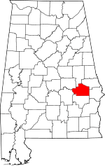 | |
| Towns | ||
| Unincorporated communities | ||
| Footnotes | ‡This populated place also has portions in an adjacent county or counties | |