Fort McKavett, Texas
| Fort McKavett | |
|---|---|
 Fort McKavett  Fort McKavett Location within the state of Texas | |
| Coordinates: 30°49′38″N 100°6′24″W / 30.82722°N 100.10667°WCoordinates: 30°49′38″N 100°6′24″W / 30.82722°N 100.10667°W | |
| Country | United States |
| State | Texas |
| County | Menard |
| Elevation | 2,169 ft (661 m) |
| Time zone | Central (CST) (UTC-6) |
| • Summer (DST) | CDT (UTC-5) |
| ZIP codes | 76841 |
| GNIS feature ID | 1357592 |
Fort McKavett is a ghost town in Menard County, Texas, United States. It lies at the intersections of Farm to Market Road 864 and Farm to Market Road 1674, 20 miles southwest of the county seat, Menard.[1] Its elevation is 2,169 feet (661 m).[2] Although it is unincorporated, it has a post office, with the ZIP code 76841.[3]
History
The settlement of Fort McKavett had its 1850s origins as a civilian population just north of Camp San Saba in Menard County (not the Camp San Saba in McCulloch County), with the name of Scabtown. Camp San Saba closed in 1859, and many residents fled to safer areas to be protected against Indian depredations. The United States Army reopened the outpost in 1869 as Fort McKavett. As the civilian population of Scabtown grew, the community was renamed after Fort McKavett, and the local economy began to thrive.[4] The Army closed the fort in 1883, but the earlier relocation of native American tribes made the civilians feel safe enough to remain. The population grew, and with it an economy that supported two hotels, three churches, a newspaper, and a mattress factory. The population peaked at 150 at the beginning of the 20th century, but declined in the latter half of the century.[5]
The writer Robert E. Howard, a Texas history enthusiast, visited Fort McKavett in 1933, and wrote: "McKavett is fascinating - a village of ruins and semiruins, people living in the old unruined barracks and officers's quarters, among the remnants of other buildings which had not stood the test of time.[6]
Notable people
Climate
The climate in this area is characterized by hot, dry summers and generally mild to cool winters. According to the Köppen climate classification system, Fort McKavett has a mid-latitude arid desert climate, BWk on climate maps.[8]
References
- ↑ Rand McNally. The Road Atlas '06. Chicago: Rand McNally, 2006, p. 100.
- ↑ U.S. Geological Survey Geographic Names Information System: Fort McKavett, Texas, Geographic Names Information System, 1979-11-30. Accessed 2007-12-29.
- ↑ Zip Code Lookup
- ↑ "Escape-Fort McKavett, Texas". Texas Escapes. Texas Escapes - Blueprints For Travel, LLC. Retrieved 25 February 2011.
- ↑ Smyrl, Vivian Elizabeth. "TSHA-Fort McKavett, Texas". Handbook of Texas Online. Texas State Historical Association. Retrieved 25 February 2011.
- ↑ Robert E. Howard's 1933 letters to H.P. Lovecraft and August Derleth, published by Glenn Lord in "The Howard Collector", Ace Books, 1979, P. 174, 176.
- ↑ Thiers BM, Halling RE (2003). "Harry D. Thiers, 1919–2000" (PDF). Mycologia. 95 (6): 1271–75. JSTOR 3761927. Retrieved 2008-02-12.
- ↑ Climate Summary for Fort McKavett, Texas
External links
- "Fort McKavett and Hill Country Frontier". Texas Beyond History. University of Texas at Austin.
Municipalities and communities of Menard County, Texas, United States | ||
|---|---|---|
| City | 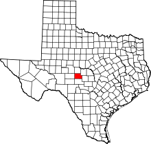 | |
| Unincorporated communities | ||
| Ghost town | ||