Flora, Louisiana
| Flora | |
|---|---|
| Unincorporated community | |
 Flora Location within the state of Louisiana | |
| Coordinates: 31°36′45″N 93°5′52″W / 31.61250°N 93.09778°WCoordinates: 31°36′45″N 93°5′52″W / 31.61250°N 93.09778°W | |
| Country | United States |
| State | Louisiana |
| Parish | Natchitoches |
| Time zone | Central (CST) (UTC-6) |
| • Summer (DST) | CDT (UTC-5) |
| GNIS feature ID | 547366[1] |
Flora is an unincorporated community in Natchitoches Parish, Louisiana, United States. It is located near the intersection of Louisiana Highway 120 and Louisiana Highway 478, south of Natchitoches.
The community is part of the Natchitoches Micropolitan Statistical Area.
References
Municipalities and communities of Natchitoches Parish, Louisiana, United States | ||
|---|---|---|
| City | 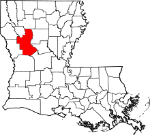 | |
| Town | ||
| Villages | ||
| CDPs | ||
| Other unincorporated communities |
| |
| Footnotes | ‡This populated place also has portions in an adjacent county or counties | |
This article is issued from Wikipedia - version of the 11/21/2014. The text is available under the Creative Commons Attribution/Share Alike but additional terms may apply for the media files.