Feodosia Municipality
| Feodosia City Municipality Феодосійська міськрада | |
|---|---|
| Municipality | |
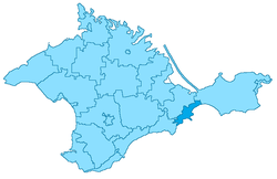 Location within Crimea | |
| Country |
Disputed: |
| Republic | Crimea |
| Capital | Feodosia |
| Subdivisions |
List
|
| Area | |
| • Total | 350 km2 (140 sq mi) |
| Population (2014) | |
| • Total | 100,962 |
| • Density | 290/km2 (750/sq mi) |
| Time zone | MSK (UTC+3) |
| Dialing code | +380-6562 ¹ |
| (1) exсept for the towns of Krasnokamenka, Kurortne and Shchebetovka - calling code +380-6566 | |
Feodosia City Municipality (Ukrainian: Феодосійська міськрада, Russian: Феодосийский горсовет, Crimean Tatar: Kefe şeer şurası), officially "the territory governed by the Feodosia city council", is one of the 25 regions of the Autonomous Republic of Crimea, a territory recognized by a majority of countries as part of Ukraine and incorporated by Russia as the Republic of Crimea. Population: 100,962 (2014 Census).[1]
It is a resort region, located in southeastern Crimea—one of the most popular recreational territories of the former Soviet Union. Besides its capital Feodosia, the region is famous for the resort town of Koktebel.
Administrative and municipal status
Within the framework of administrative divisions of Russia, Feodosia is, together with a number of urban and rural localities, incorporated separately as the town of republican significance of Feodosia—an administrative unit with the status equal to that of the districts.[2] As a municipal division, the town of republican significance of Feodosia is incorporated as Feodosia Urban Okrug.[3]
Within the framework of administrative divisions of Ukraine, Feodosia is incorporated as the town of republican significance of Feodosia.[4] Ukraine does not have municipal divisions.
Besides the city of Feodosia, the municipality includes five towns and 12 villages which are organised into seven town and village communities.
Former names which were officially changed in 1945-49 after the deportation of Crimean Tatars and are now used only by the Crimean Tatar community are mentioned in brackets.
- Beregovoye Village Community
- Beregovoye (Qoran Eli)
- Stepnoye
- Koktebel Town Community
- Koktebel
- Nanikove (Baraq Göl)
- Nasypnoye Villagу Community
- Nasypnoye (Nasipköy)
- Blyzhnye (Bay Buğa)
- Vynogradnoye (Kürey Başı)
- Pionerskoye (Gertsenberg)
- Podgornoye
- Solnechnoye (Paşa Töpe)
- Yuzhnoye (Sultan Sala)
- Ordzhonikidze Town Community
- Ordzhonikidze (Kaygador)
- Prymorskyi Town Community
- Prymorskyi (Hafuz)
- Shchebetovka Town Community
- Shchebetovka (Otuz)
- Krasnokamyanka (Qızıltaş)
- Kurortnoye (Aşağı Otuz)
References
Notes
- ↑ Russian Federal State Statistics Service (2014). "Таблица 1.3. Численность населения Крымского федерального округа, городских округов, муниципальных районов, городских и сельских поселений" [Table 1.3. Population of Crimean Federal District, Its Urban Okrugs, Municipal Districts, Urban and Rural Settlements]. Федеральное статистическое наблюдение «Перепись населения в Крымском федеральном округе». ("Population Census in Crimean Federal District" Federal Statistical Examination) (in Russian). Federal State Statistics Service. Retrieved January 4, 2016.
- ↑ Law of the Republic of Crimea #35-ZRK
- ↑ Law of the Republic of Crimea #15-ZRK
- ↑ Чисельність наявного населення України (in Ukrainian). State Service of Statistics. Retrieved 8 August 2014.
Sources
- Государственный Совет Республики Крым. Закон №18-ЗРК от 6 июня 2014 г. «Об административно-территориальном устройстве Республики Крым». Вступил в силу через 10 дней со дня официального опубликования. Опубликован: "Крымские известия", №118–119 (5529–5530), 11 июня 2014 г.. (State Council of the Republic of Crimea. Law #18-ZRK of June 6, 2014 On the Administrative-Territorial Structure of the Republic of Crimea. Effective as of the day which is 10 days after the day of the official publication.).
- Государственный Совет Республики Крым. Закон №15-ЗРК от 5 июня 2014 г. «Об установлении границ муниципальных образований и статусе муниципальных образований в Республике Крым», в ред. Закона №93-ЗРК/2015 от 5 мая 2015 г. «О внесении изменения в Закон Республики Крым от 5 июня 2014 года №15-ЗРК "Об установлении границ муниципальных образований и статусе муниципальных образований в Республике Крым"». Вступил в силу через десять дней со дня официального опубликования. Опубликован: "Крымские известия", №118–119 (5529–5530), 11 июня 2014 г. (State Council of the Republic of Crimea. Law #15-ZRK of June 5, 2014 On Establishing the Borders of the Municipal Formations and the Status of the Municipal Formations in the Republic of Crimea, as amended by the Law #93-ZRK/2015 of May 5, 2015 On Amending the Law #15-ZRK of the Republic of Crimea of June 5, 2014 "On Establishing the Borders of the Municipal Formations and the Status of the Municipal Formations in the Republic of Crimea". Effective as of the day which is ten days after the day of the official publication.).
| Cities | ||
|---|---|---|
| Urban-type settlements |
| |
| Villages |
| |
| Raions | |||||||
|---|---|---|---|---|---|---|---|
| Municipalities | |||||||
| Cities | |||||||
| |||||||
Coordinates: 45°02′56″N 35°22′45″E / 45.04889°N 35.37917°E