Farm to Market Road 3078
| ||||
|---|---|---|---|---|
 | ||||
| Route information | ||||
| Maintained by TxDOT | ||||
| Length: | 14.678 mi[1] (23.622 km) | |||
| Existed: | 1992 – present | |||
| History: | Formerly a route in Maverick and Zavala counties | |||
| Major junctions | ||||
| West end: |
| |||
| East end: |
| |||
| Location | ||||
| Counties: | Reeves, Jeff Davis | |||
| Highway system | ||||
| ||||

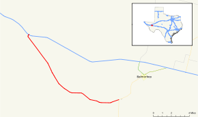
Farm to Market Road 3078 (FM 3078) is a 14.7-mile (23.7 km) road maintained by the Texas Department of Transportation (TxDOT) that connects Interstate 10 (I-10) to State Highway 17 (SH 17) in Toyahvale. The route is in Jeff Davis and Reeves counties and connects Toyahvale to points farther west along I-10 including Kent and Van Horn. FM 3078 is part of the state's Farm and Ranch to Market Road System.
Between 1966 and 1983 the numerical designation was assigned to a road in Maverick and Zavala counties. The current road was previously assigned as SH 27 and then U.S. Route 290 before the completion of I-10 locally.
The road was formerly part of a major route connecting El Paso to central and southern Texas and was accordingly constructed better than its current designation would suggest. The road is entirely rural in nature with no major intersections between its termini.
History
Maverick and Zavala counties
Ranch to Market Road 3078 was in 1966 originally the designation of a 7.0-mile (11.3 km) road in Maverick County extending northeastward from the former SH 76, a road that would become SH 57 that same year, and then US 57 since 1971. In 1978, RM 3078 was extended an additional 4.0 miles (6.4 km) and was re-designated as a farm to market road. In 1980, the route was extended an additional 17.7 miles (28.5 km) through Zavala County to FM 481 at the county line between Zavala and Uvalde counties. In 1983, the route was designated as an extension of FM 481.[1]
Jeff Davis and Reeves counties

The present route was originally part of SH 27. That highway had been proposed as early as 1919[2] and, after TxDOT's predecessor, the Texas Highway Department, gained authority to maintain state highways in 1924,[3] SH 17 had become part of the state highway system by 1933 and concurrent with US 290.[4] By 1939, the SH 27 designation along the present day FM 3078 had been cancelled.[5]
In the early 1980s, the I-10 bypass around Balmorhea and Toyahvale had been completed.[6] With the completion of the Interstate, US 290 through much of West Texas became largely concurrent with the Interstate separating only to serve as a sort of business route into towns bypassed by the Interstate. With the creation of Interstate business routes, US 290 became obsolete on the portion running along I-10 and its route designation over that portion was canceled in 1992.[7] The entire portion of US 290 through Toyahvale and Balmorhea, part of which was concurrent with SH 17, did not become a new Interstate business route. Instead, Business Route 10-F separated from I-10 at FM 2903 to enter Balmorhea and rejoin the Interstate along SH 17.[8] FM 3078 was designated in 1992 along the portion of US 290 between I-10 and SH 17 to allow that stretch of highway not concurrent with SH 17 to have a highway designation when the US 290 designation was canceled.
Route description
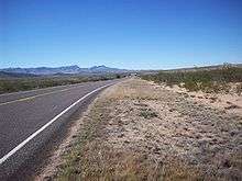
FM 3078 is unusually well built for a rural farm to market road due to its former status as a U.S. highway. The two-lane road has broad lanes and paved shoulders. The road has bridges over all water crossings and no sharp turns or curves allowing a 70 mile per hour speed limit. The road travels through ranch land just north of the foothills of the Davis Mountains. There are no major intersections along the length of the road, and the road passes through no cities or towns before reaching its eastern terminus at Toyahvale. Along SH 17 about 0.33 miles (0.53 km)[9] beyond the terminus at Toyahvale is a junction with Park Road 30 at Balmorhea State Park.
The western terminus at I-10 is in Reeves County. The road enters Jeff Davis County 5.0 miles (8.0 km) eastward. The route is in Jeff Davis County for 4.7 miles (7.6 km) before returning to Reeves County for the remainder of the route.[9]
Major intersections
| County | Location | mi[1] | km | Destinations | Notes | |||
|---|---|---|---|---|---|---|---|---|
| Reeves | | 0.0 | 0.0 | Western terminus | ||||
| Jeff Davis |
No major junctions | |||||||
| Reeves | Toyahvale | 14.7 | 23.7 | Eastern terminus | ||||
| 1.000 mi = 1.609 km; 1.000 km = 0.621 mi | ||||||||
See also
References
- 1 2 3 Transportation Planning and Programming Division (n.d.). "Farm to Market Road No. 3078". Highway Designation Files. Texas Department of Transportation. Retrieved December 7, 2009.
- ↑ Texas State Highway Department (October 1, 1919). Highway Map of Texas (Map). [1:1,584,000]. Austin: Texas State Highway Department – via Texas State Library and Archives Commission.
- ↑ Texas Department of Transportation (n.d.). "TxDOT History: 1917-1930". Texas Department of Transportation. Archived from the original on April 13, 2013.
- ↑ Texas State Highway Commission (1933). Official Map of the Highway System of Texas (Map). [1:2,172,342]. Austin: Texas State Highway Commission – via Texas State Library and Archives Commission.
- ↑ Transportation Planning and Programming Division (n.d.). "State Highway No. 27". Highway Designation Files. Texas Department of Transportation.
- ↑ AARoads, Texas @ AARoads - Interstate-10
- ↑ Transportation Planning and Programming Division (n.d.). "U.S. Highway No. 290". Highway Designation Files. Texas Department of Transportation.
- ↑ Transportation Planning and Programming Division (n.d.). "Business Interstate Highway No. 10-F". Highway Designation Files. Texas Department of Transportation.
- 1 2 Texas Department of Transportation. Statewide Planning Map (Map). Austin: Texas Department of Transportation.
External links
 Geographic data related to Farm to Market Road 3078 at OpenStreetMap