Færder National Park
| Færder National Park | |
|---|---|
 | |
| Location | Nøtterøy and Tjøme, Norway |
| Nearest city | Tønsberg |
| Coordinates | 59°07′N 10°31′E / 59.12°N 10.52°ECoordinates: 59°07′N 10°31′E / 59.12°N 10.52°E |
| Area |
340 km2 (130 sq mi), of which 15 km2 (5.8 sq mi) is land 325 km2 (125 sq mi) is water |
| Established | 23 August 2013 |
| Governing body | Norwegian Environment Agency |
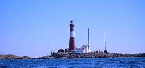
Færder National Park (Norwegian: Færder nasjonalpark) is a national park in Nøtterøy and Tjøme in Vestfold, Norway. It is mostly a marine park, and includes some islands and coastal areas. To the east, the national park borders to the Ytre Hvaler National Park. Færder covers an area of 340 km2 (130 sq mi), of which 325 km2 (125 sq mi) is sea and 15 km2 (6 sq mi) is land. The park was established on 23 August 2013. The park includes large parts of the archipelago of Bolærne, as well as the protected Færder Lighthouse and the ruins of Store Færder Lighthouse with its associated protected buildings.[1][2][3][4]
References
- ↑ "Forskrift om vern av Færder nasjonalpark, Nøtterøy og Tjøme kommuner, Vestfold" (PDF) (in Norwegian). www.regjeringen.no. 2013. Retrieved 19 March 2015.
- ↑ Lundbo, Sten; Askheim, Svein. "Færder nasjonalpark". In Godal, Anne Marit. Store norske leksikon (in Norwegian). Oslo: Norsk nettleksikon. Retrieved 19 March 2015.
- ↑ "Færder nasjonalpark er oppretta" (in Norwegian). Government.no. Retrieved 19 March 2015.
- ↑ "Færder er ny nasjonalpark" (in Norwegian). Miljødirektoratet. Retrieved 19 March 2015.

This article is issued from Wikipedia - version of the 4/15/2015. The text is available under the Creative Commons Attribution/Share Alike but additional terms may apply for the media files.