Emmett, Idaho
| Emmett, Idaho | |
|---|---|
| City | |
|
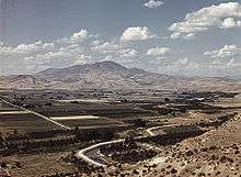
View of Emmett | |
 Location in Gem County and the state of Idaho | |
 Emmett, Idaho Location in the United States | |
| Coordinates: 43°52′22″N 116°29′42″W / 43.87278°N 116.49500°WCoordinates: 43°52′22″N 116°29′42″W / 43.87278°N 116.49500°W | |
| Country | United States |
| State | Idaho |
| County | Gem |
| Area[1] | |
| • Total | 2.82 sq mi (7.3 km2) |
| • Land | 2.80 sq mi (7.3 km2) |
| • Water | 0.02 sq mi (0.05 km2) |
| Elevation | 2,362 ft (720 m) |
| Population (2010)[2] | |
| • Total | 6,557 |
| • Estimate (2012[3]) | 6,516 |
| • Density | 2,341.8/sq mi (904.2/km2) |
| Time zone | Mountain (MST) (UTC-7) |
| • Summer (DST) | MDT (UTC-6) |
| ZIP code | 83617 |
| Area code(s) | 208 |
| FIPS code | 16-25570 |
| GNIS feature ID | 0397688 |
| Website | cityofemmett.org |

Emmett is a city in Gem County, Idaho, United States. The population was 6,557 at the 2010 census,up from 5,490 in 2000.[4] It is the county seat[5] and the only city in the county. Emmett is part of the Boise−Nampa, Idaho Metropolitan Statistical Area.
History

Rising some 5,906 feet (1,800 m) above sea level, Squaw Butte, named by Native Americans who used this area as their winter resort, stands at the north end of the valley. The Payette River was named after Francois Payette, a fur trader from Quebec who was put in charge of old Fort Boise in 1818 and traveled through the area. Permanent settlement began in the early 1860s, after gold discoveries in the Boise Basin brought people over the established stage and pack train routes. Two of these trails joined at the Payette River north of the present river bridge in Emmett.
Originally called "Emmettville," it was primarily a post office named after Emmett Cahalan, the son of Tom Cahalan, an early settler of the area. The post office was later moved but retained the name. A few years later the "ville" was dropped and the post office and town became simply Emmett. In 1883 James Wardwell had the town platted, and in 1900 the town was incorporated as Emmett. Later, in March 1902, the Idaho Northern railroad came to the valley.[6]
After the closing of the mines in 1906, the power lines were extended to Emmett. A series of irrigation projects made it possible for more rapid expansion of the town as the major service center for a farming and fruit-growing valley. In the early 1900s fruit packers adopted the label of "Gem of Plenty" because of the fertility of the valley. During the mining era the valley was known as the "garden" for the mining regions. [7]
Until 2001, the city was home to a Boise Cascade manufacturing facility.[8] The Black Canyon diversion dam on the Payette River, built in the early 1920s, is east of the city.[9]
While campaigning for a return to Congress in 1934, Robert M. McCracken died in an automobile accident near Emmett. His vehicle went through a guard rail and tumbled down Freezeout Hill.[10]
Geography
According to the United States Census Bureau, the city has a total area of 2.82 square miles (7.30 km2), of which, 2.80 square miles (7.25 km2) is land and 0.02 square miles (0.05 km2) is water.[1] It is located south of the Payette River, at an elevation of 2,362 feet (720 m) above sea level.
Demographics
| Historical population | |||
|---|---|---|---|
| Census | Pop. | %± | |
| 1910 | 1,351 | — | |
| 1920 | 2,204 | 63.1% | |
| 1930 | 2,763 | 25.4% | |
| 1940 | 3,203 | 15.9% | |
| 1950 | 3,067 | −4.2% | |
| 1960 | 3,769 | 22.9% | |
| 1970 | 3,945 | 4.7% | |
| 1980 | 4,605 | 16.7% | |
| 1990 | 4,601 | −0.1% | |
| 2000 | 5,490 | 19.3% | |
| 2010 | 6,557 | 19.4% | |
| Est. 2015 | 6,604 | [11] | 0.7% |
2010 census
As of the census[2] of 2010, there were 6,557 people, 2,616 households, and 1,635 families residing in the city. The population density was 2,341.8 inhabitants per square mile (904.2/km2). There were 2,916 housing units at an average density of 1,041.4 per square mile (402.1/km2). The racial makeup of the city was 91.1% White, 0.2% African American, 0.6% Native American, 0.7% Asian, 0.1% Pacific Islander, 4.6% from other races, and 2.6% from two or more races. Hispanic or Latino of any race were 12.7% of the population.
There were 2,616 households of which 33.6% had children under the age of 18 living with them, 44.5% were married couples living together, 13.0% had a female householder with no husband present, 5.0% had a male householder with no wife present, and 37.5% were non-families. 32.3% of all households were made up of individuals and 17.2% had someone living alone who was 65 years of age or older. The average household size was 2.46 and the average family size was 3.12.
The median age in the city was 36.3 years. 27.2% of residents were under the age of 18; 8.4% were between the ages of 18 and 24; 24.7% were from 25 to 44; 22.3% were from 45 to 64; and 17.4% were 65 years of age or older. The gender makeup of the city was 48.4% male and 51.6% female.
2000 census
As of the census[13] of 2000, there were 5,490 people, 2,095 households, and 1,412 families residing in the city. The population density was 3,022.5 people per square mile (1,164.7/km²). There were 2,264 housing units at an average density of 1,246.4 per square mile (480.3/km²). The racial makeup of the city was 90.60% White, 0.07% African American, 0.75% Native American, 0.44% Asian, 0.15% Pacific Islander, 5.79% from other races, and 2.20% from two or more races. Hispanic or Latino of any race were 11.57% of the population.
There were 2,095 households out of which 34.4% had children under the age of 18 living with them, 50.5% were married couples living together, 12.9% had a female householder with no husband present, and 32.6% were non-families. 28.3% of all households were made up of individuals and 14.9% had someone living alone who was 65 years of age or older. The average household size was 2.55 and the average family size was 3.13.
In the city the population was spread out with 28.4% under the age of 18, 9.1% from 18 to 24, 26.3% from 25 to 44, 18.4% from 45 to 64, and 17.8% who were 65 years of age or older. The median age was 35 years. For every 100 females there were 90.6 males. For every 100 females age 18 and over, there were 85.5 males.
The median income for a household in the city was $26,480, and the median income for a family was $34,663. Males had a median income of $30,598 versus $19,088 for females. The per capita income for the city was $13,027. About 16.3% of families and 17.8% of the population were below the poverty line, including 23.4% of those under age 18 and 16.5% of those age 65 or over.
Highways
 - SH-16 (south) - connects to Boise (southeast) via SH-44
 - SH-52 - to Payette (west) and Horseshoe Bend (east)[14]
Climate
Emmett experiences a semi-arid climate (Köppen BSk) with cold, moist winters and hot, dry summers.
| Climate data for Emmett (1971–2000) | |||||||||||||
|---|---|---|---|---|---|---|---|---|---|---|---|---|---|
| Month | Jan | Feb | Mar | Apr | May | Jun | Jul | Aug | Sep | Oct | Nov | Dec | Year |
| Average high °F (°C) | 36.6 (2.6) |
44.9 (7.2) |
55.0 (12.8) |
63.2 (17.3) |
72.2 (22.3) |
81.3 (27.4) |
89.9 (32.2) |
88.9 (31.6) |
78.7 (25.9) |
65.9 (18.8) |
48.5 (9.2) |
37.7 (3.2) |
63.6 (17.6) |
| Average low °F (°C) | 23.0 (−5) |
27.8 (−2.3) |
32.9 (0.5) |
37.9 (3.3) |
45.0 (7.2) |
52.2 (11.2) |
58.0 (14.4) |
56.8 (13.8) |
48.5 (9.2) |
39.1 (3.9) |
30.5 (−0.8) |
24.0 (−4.4) |
39.6 (4.2) |
| Average precipitation inches (mm) | 1.72 (43.7) |
1.60 (40.6) |
1.58 (40.1) |
1.21 (30.7) |
1.29 (32.8) |
0.82 (20.8) |
0.30 (7.6) |
0.33 (8.4) |
0.71 (18) |
0.87 (22.1) |
1.72 (43.7) |
1.66 (42.2) |
13.81 (350.7) |
| Source: NOAA (normals, 1971–2000) [15] | |||||||||||||
Notable people
- Carlos Bilbao, member of the Idaho House of Representatives.
- Ammon Bundy, leader of the occupation of the Malheur National Wildlife Refuge.
- Sarah Downs, 2013 Miss Idaho.
- Hattie Johnson, Olympic shooter.
- Aaron Paul, Emmy Award-winning actor born in Emmett.[16]
- Clayne L. Pope, professor of economics at Brigham Young University.
- Paul Graham Popham, U.S. Special Forces Vietnam, Bronze Star. General Manager McGraw Hill, Inc. AIDS activist.
- Steven Thayn, member of Idaho House of Representatives.
See also
References
- 1 2 "US Gazetteer files 2010". United States Census Bureau. Retrieved 2012-12-18.
- 1 2 "American FactFinder". United States Census Bureau. Retrieved 2012-12-18.
- ↑ "Population Estimates". United States Census Bureau. Retrieved 2013-06-03.
- ↑ "Quickfacts: Emmett, Idaho". United States Census Bureau, Population Division. 2010. Retrieved 2011-12-08.
- ↑ "Find a County". National Association of Counties. Retrieved 2011-06-07.
- ↑ , Gem County Historical Society, accessed 2011-07-20
- ↑ , United Country Musick & Sons Auctions / Real Estate Accessed 2011-7-11
- ↑ Boise Cascade Announces Closure of Plywood, Lumber Operations in Idaho, Boise Cascade, 2001-02-13. Accessed 2009-03-31.
- ↑ USBR - Black Canyon Dam Archived June 7, 2009, at the Wayback Machine.
- ↑ "Robert McCracken, Candidate for Congress, killed". Lewiston Morning Tribune. Associated Press. May 17, 1934. p. 1.
- ↑ "Annual Estimates of the Resident Population for Incorporated Places: April 1, 2010 to July 1, 2015". Retrieved July 2, 2016.
- ↑ "Census of Population and Housing". Census.gov. Retrieved June 4, 2015.
- ↑ "American FactFinder". United States Census Bureau. Retrieved 2008-01-31.
- ↑ Rand McNally. The Road Atlas '09. Chicago: Rand McNally, 2009, p. 31.
- ↑ "Climatography of the United States NO.81" (PDF). National Oceanic and Atmospheric Administration. Retrieved January 13, 2011.
- ↑ "Aaron Paul Biography".
External links
| Wikimedia Commons has media related to Emmett, Idaho. |
- Official website
- Chamber of Commerce - Emmett and Gem County
- Emmett School District #221
Municipalities and communities of Gem County, Idaho, United States | ||
|---|---|---|
| City | ||
| Unincorporated communities | ||