Doubrava (Aš)
| Doubrava | |
| Village | |
 | |
| Official name: Doubrava | |
| Country | Czech Republic |
|---|---|
| Region | Karlovy Vary |
| District | Cheb |
| Municipality | Aš |
| Elevation | 507 m (1,663 ft) |
| Coordinates | CZ 50°15′38″N 12°14′22″E / 50.26056°N 12.23944°ECoordinates: CZ 50°15′38″N 12°14′22″E / 50.26056°N 12.23944°E |
| Area | 3.83 km2 (1.5 sq mi) |
| Population | 94 (2001) |
| Density | 25/km2 (65/sq mi) |
| First mentioned | 1392 |
| Timezone | CET (UTC+1) |
| - summer (DST) | CEST (UTC+2) |
| Postal code | 35201 |
| Wikimedia Commons: Doubrava (Aš) | |
Doubrava (German: Grün) is a village in Karlovy Vary Region, Czech Republic. It is one of the nine districts of the town of Aš. In 2001 the village had a population of 94.
In the village there are a mineral spring, a bus stop, a market and a restaurant.
Geography
Doubrava lies 6 kilometres northeast from Aš, about 507 meters above sea level. It is surrounded by forests. Through Doubrava flows Bílý Halštrov river.
History
Doubrava is first mentioned in 1392, as a property of Conrad von Neuberg. At the turn of the 14th and 15th century Doubrava was bought by the Zedtwitz.
Mineral springs in Doubrava has very similar composition like those in neighboring German town of Bad Elster. But they are not used for medical purposes yet. Town of Aš plans change in future and revitalise this village.
| Year | 1850 | 1930 | 1947 | 1961 | 1970 | 2001 |
|---|---|---|---|---|---|---|
| Population | 637 | 808 | 289 | 180 | 140 | 94 |
Landmarks
- Chateau Doubrava from 17th century,
- Tomb of Zedtwitz,
- Wooden cemetery morgue.
Gallery
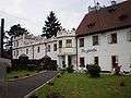 Zedtwitz chateau Doubrava.
%2C_pavilion_of_mineral_well_2009-04-24.jpg) Pavilion od mineral well.
Pavilion od mineral well.
References
- ↑ Progress of population of Doubrava between 1850 and 2001, according to: Obce Ašska v proměnách času, Kolektiv autorů, MÚ Aš (2005)