Dobson, Kentucky
| Dobson | |
|---|---|
| Unincorporated community | |
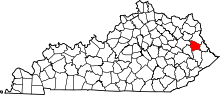
 Dobson  Dobson Location within the state of Kentucky | |
| Coordinates: 37°44′31″N 82°53′06″W / 37.74194°N 82.88500°WCoordinates: 37°44′31″N 82°53′06″W / 37.74194°N 82.88500°W | |
| Country | United States |
| State | Kentucky |
| County | Johnson |
| Elevation | 659 ft (201 m) |
| Time zone | Eastern (EST) (UTC-5) |
| • Summer (DST) | EDT (UTC-4) |
| GNIS feature ID | 507860 |
Dobson is an unincorporated community in Johnson County, Kentucky, United States. It is located at an elevation of 659 feet (201 m).[1] Dobson is located in the ZIP Code Tabulation Area for ZIP code 41240.
References
- ↑ U.S. Geological Survey Geographic Names Information System: Dobson, Kentucky Retrieved on 2010-1-5
This article is issued from Wikipedia - version of the 7/27/2016. The text is available under the Creative Commons Attribution/Share Alike but additional terms may apply for the media files.