Damaraland
| Republic of Damaraland | ||||||||||
| Republiek van Damaraland Republik Damaraland | ||||||||||
| Bantustan | ||||||||||
| ||||||||||
|
| ||||||||||
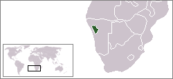 Location of Damaraland (green) within South West Africa (grey). | ||||||||||
| Capital | Khorixas | |||||||||
| Languages | Khoekhoe Herero English Afrikaans German | |||||||||
| Political structure | Bantustan | |||||||||
| History | ||||||||||
| • | Self-government | 1980 | ||||||||
| • | Re-integrated into Namibia | May 1989 | ||||||||
| Currency | Namibian dollar | |||||||||
| ||||||||||

Damaraland was a name given to the north-central part of what later became Namibia, inhabited by the Damaras. It was bounded roughly by Ovamboland in the north, the Namib Desert in the west, the Kalahari Desert in the east, and Windhoek in the south.
In the 1970s the name Damaraland was revived for a bantustan in South West Africa (present-day Namibia), intended by the apartheid government to be a self-governing homeland for the Damara people. A centrally administered local government was created in 1980. The bantustan Damaraland was situated on the western edge of the territory that had been known as Damaraland in the 19th century.
Damaraland, like other homelands in South West Africa, was abolished in May 1989 at the start of the transition to independence.
The name Damaraland predates South African control of Namibia, and was described as "the central portion of German South-West Africa" in the Encyclopædia Britannica Eleventh Edition.[1]
See also
References
- ↑
 "Damaraland". Encyclopædia Britannica. 7 (11th ed.). 1911. p. 783.
External links
| |||||||||||||||||||||||||||||||||||||||||||||||||||||||||||||||||||||||||||||||||||||||||||||||||||||||||||||||||||||||||||||||||||||||||||||||||||||||||||||||||||||||||