Dairyland (community), Wisconsin
| Dairyland, Wisconsin | |
|---|---|
| Unincorporated community | |
 Dairyland  Dairyland | |
| Coordinates: 46°12′58″N 92°09′20″W / 46.21611°N 92.15556°WCoordinates: 46°12′58″N 92°09′20″W / 46.21611°N 92.15556°W | |
| Country | United States |
| State | Wisconsin |
| County | Douglas |
| Town | Dairyland |
| Elevation | 1,119 ft (341 m) |
| Time zone | Central (CST) (UTC-6) |
| • Summer (DST) | CDT (UTC-5) |
| Area code(s) | 715 and 534 |
| GNIS feature ID | 1563661[1] |
Dairyland is an unincorporated community in the town of Dairyland, Douglas County, Wisconsin, United States.
Wisconsin Highway 35 and County Road T are two of the main routes in the community.
The community is located 25 miles southwest of Solon Springs; 36 miles south of the city of Superior, and 20 miles northeast of Danbury.
References
Municipalities and communities of Douglas County, Wisconsin, United States | ||
|---|---|---|
| City | 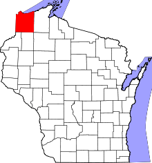 | |
| Villages | ||
| Towns | ||
| CDPs | ||
| Unincorporated communities |
| |
| Indian reservation | ||
| Footnotes | ‡This populated place also has portions in an adjacent county or counties | |
This article is issued from Wikipedia - version of the 7/28/2016. The text is available under the Creative Commons Attribution/Share Alike but additional terms may apply for the media files.