Cyclone Ingrid
| Category 5 severe tropical cyclone (Aus scale) | |
|---|---|
| Category 4 (Saffir–Simpson scale) | |
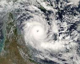 Tropical Cyclone Ingrid on 8 March 2005 | |
| Formed | 4 March 2005 |
| Dissipated | 16 March 2005 |
| Highest winds |
10-minute sustained: 230 km/h (145 mph) 1-minute sustained: 250 km/h (155 mph) Gusts: 325 km/h (200 mph) |
| Lowest pressure | 924 hPa (mbar); 27.29 inHg |
| Fatalities | 5+ direct |
| Damage | At least $14.4 million (2005 USD) |
| Areas affected | Northern Queensland, Northern Territory, Northern Western Australia |
| Part of the 2004-05 Australian region cyclone season | |
Cyclone Ingrid was a tropical cyclone which struck northern Australia during the 2004-05 Australian region cyclone season. Its minimum pressure was 924 mbar (hPa).[1]
Meteorological history

Originally a low pressure system north of the Gulf of Carpentaria, Ingrid moved eastward and developed into a Tropical Cyclone in the Coral Sea on 6 March 2005. A strong pressure gradient rapidly developed within the system as it headed west resulting in a category rating of 5 by 8 March. The eye, with very destructive wind gusts up to 220 km/h within a 20 km radius, reached the far northern coast of the Australian state of Queensland between 6 am and 9 am on 10 March 2005 AEST, and hit the Cape York Peninsula. However, it was downgraded to a Category 2 storm as it crossed the peninsula north of the towns of Coen and Lockhart River.
After passing the town of Weipa, Ingrid gained strength once again as it moved out across the Gulf of Carpentaria towards the Northern Territory. It struck the town of Nhulunbuy as a Category 5 storm. It crossed the Cobourg Peninsula in the early hours of 13 March, heading west. Ingrid struck the Tiwi Islands as a Category 4 storm, and moved west into the Timor Sea, being downgraded to a category 3 due to the passage over land. Winds were in excess of 200 km/h.
On 15 March Ingrid approached the north coast of the Kimberley region of Western Australia as a Category 4 storm, and made landfall near Kalumburu shortly afterwards. It quickly weakened as it moved inland, and soon completely dissipated.
(Note: The storm categories above are as defined by the Australian Bureau of Meteorology,[2] and differ from those used in the United States.)
Preparations
Queensland
In Far North Queensland, several hundred residents, including some aborigines, evacuated from areas deemed vulnerable to shelters by 9 March.[3] Tourists in resorts on Lizard Island and Cape Tribulation were evacuated the same day.[4] Local communities throughout the coastline were supplied with sandbags and relief materials. To reduce damage from trees, workers cut numerous trees down ahead of the storm. Three aborigine communities, with a total population of 1,500, and nearby Cooktown, home to 2,000 people, were placed on standby for evacuation. In Cairns, emergency officials stockpiled sandbags and concerns were raised about 20% of the 130,000 people that live in the city never experiencing a cyclone within the past five years.[5] In Lockhart River, an estimated 700 people evacuated to shelters prior to the storm.[6] On the western coast of Queensland, residents took precautions prior to a weakened Ingrid as a "code blue alert" was declared.[7]
Northern Territory
On 11 March, officials in the Northern Territory advised the 4,000 residents of Nhulunbuy to evacuate to higher ground.[8] On Melville Island, 1,500 aborigines evacuated to shelter throughout the island. One of the most important local events, the Australian rules football final, was canceled due to Ingrid. On Croker Island, 300 residents evacuated to cyclone shelters prior to the storm.[9]
Western Australia
In Kalumburu, residents in the most vulnerable areas were evacuated to shelters.[10]
Impact

Papua New Guinea
Rough seas produced by Cyclone Ingrid capsized a boat off the coast of Papua New Guinea, killing five of the 13 occupants.[11]
Queensland
Damages from the storm in Queensland amounted to A$5.3 million ($4.1 million USD).[12]
Northern Territory
The isolated communities along the coast of Northern Territory suffered considerable damage, and there was localised flooding in the coastal areas due to high tides.
On Croker Island, 30 homes sustained damage, some of which lost their roofs, numerous trees were downed, power was cut to most residences, cars were completely destroyed and numerous roads were damaged.[9] Nearly all trees on the island were leveled by 290 km/h (180 mph) wind gusts. Schools were reportedly destroyed in addition to several homes. Much of the infrastructure of the Tiwi Islands was affected, some suffering consequential damage due to trees falling on buildings and vehicles. Damages on the islands amounted to A$5 million ($3.9 million USD).[13] Throughout the Northern Territory, an additional A$10 million ($6.4 million USD) in damages resulted from Ingrid.[14]
Darwin experienced high winds and heavy rain, but was only affected by the southern edge of the cyclone.
Western Australia
The Great Northern Highway was closed between Kununurra and Halls Creek for a period of 36 hours due to flooding.
A resort area, known as "Faraway Bay", northeast of Kalumburu was completely destroyed by the storm. Numerous boats were found 100 m (330 ft) inland after being washed away by the storm surge. Numerous homes lost power and water supply, some sustained major roof damage and severe flooding isolated a few communities. Large areas of forested area were completely destroyed by Ingrid.[13]
See also
References
- ↑ "Tropical Cyclone Ingrid". Bureau of Meteorology. Retrieved 11 August 2011.
- ↑ Surviving Cyclones in Australia
- ↑ Staff Writer (10 March 2005). "Cyclone weakens over Queensland". BBC News. Retrieved 22 June 2009.
- ↑ Staff Writer (9 March 2005). "Resorts evacuated as cyclone nears coast". Travel Weekly. Retrieved 22 June 2009.
- ↑ AAP (8 March 2005). "Cyclone Ingrid gathers force". The Age. Retrieved 22 June 2009.
- ↑ AAP (10 March 2005). "Cyclone Ingrid hits Queensland coast". The Age. Retrieved 22 June 2009.
- ↑ Staff Writer (10 March 2009). "Cyclone Ingrid hits Qld coast". ABC News Online. Retrieved 22 June 2009.
- ↑ Roberta Mancuso (11 March 2005). "Qld: NT evacuations as Cyclone Ingrid nears". AAP General News. Retrieved 22 June 2009.
- 1 2 Lindsay Murdoch (14 March 2005). "Melville Island lashed by ferocious Ingrid". The Age. Retrieved 22 June 2005.
- ↑ Tim Clarke (15 March 2005). "WA: WA braces for Ingrid impact as Kimberley residents evacuate". AAP General News. Retrieved 22 June 2009.
- ↑ Staff Writer (11 March 2005). "Five Papuan New Guineans die when boat capsizes during cyclone". Radio New Zealand. Retrieved 22 June 2009.
- ↑ "Interim report on severe tropical cyclone Ingrid" (PDF). Coastal Services Unit, Environmental Sciences Division. April 2005. Retrieved 22 June 2009.
- 1 2 "EMA Disaster Database: Cyclone Ingrid". Australian Emergency Management Agency. 13 September 2006. Retrieved 22 June 2009.
- ↑ Syd Stirling (2 April 2005). "Disaster Relief Activated for Cyclone Ingrid Damage" (PDF). Northern Territory Government. Archived from the original (PDF) on 28 October 2009. Retrieved 22 June 2009.
External links
| Wikimedia Commons has media related to Cyclone Ingrid. |
- Australian Bureau of Meteorology: Tropical Cyclone Ingrid
- Darwin spared Ingrid's fury (Aust BC News, 14 March 2005. 10:58pm, AEDT)
- Ingrid batters top end (from ABC News Online - Saturday, 12 March 2005. 8:36pm AEDT)
- Cyclone Ingrid maintains intensity (from ABC News Online - Wednesday, 9 March 2005. 1:03am AEDT)
- Emergency services prepare for Cyclone Ingrid (from ABC News Online - Tuesday, 8 March 2005. 10:09pm AEDT)
- The wind velocities were subsequently reassessed based on meteorological and observed damage on the ground and findings delivered at a seminar in Darwin on 7 September 2005.
| 1960s | |
|---|---|
| 1970s | |
| 1980s | |
| 1990s | |
| 2000s | |
| 2010s | |
| |