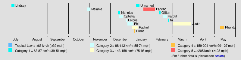
1996–97 Australian region cyclone season
| |
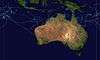
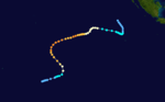
| Season summary map |
| First system formed |
July 9, 1996 |
| Last system dissipated |
May 16, 1997 |
| Strongest storm1 |
Pancho-Helinda – 910 hPa (mbar), 205 km/h (125 mph) (10-minute sustained) |
| Total fatalities |
Unknown |
| Total damage |
Unknown |
| 1Strongest storm is determined by lowest pressure |
Australian region tropical cyclone seasons
1994–95, 1995–96, 1996–97, 1997–98, 1998–99 |
| Related articles |
|
|
The 1996–97 Australian region cyclone season was an event in the ongoing cycle of tropical cyclone formation. It ran from 1 November 1996 to 30 April 1996. The regional tropical cyclone operational plan also defines a tropical cyclone year separately from a tropical cyclone season, and the "tropical cyclone year" ran from 1 July 1996 to 30 June 1997.
Tropical cyclones in this area were monitored by four Tropical Cyclone Warning Centres (TCWCs): the Australian Bureau of Meteorology in Perth, Darwin, and Brisbane; and TCWC Port Moresby in Papua New Guinea.
Season summary
Storms
Tropical Cyclone Lindsay
| Category 1 tropical cyclone (Australian scale) |
| Tropical storm (SSHWS) |
|
|
| Duration |
9 July – 13 July |
| Peak intensity |
75 km/h (45 mph) (10-min) 990 hPa (mbar) |
On 9 July, TCWC Perth reported that a tropical low had developed within the Near-equatorial trough of low pressure, located about 500 km (310 mi) to the northeast of the Cocos Islands.[1] During that day the system moved to the southwest around a weak mid-upper level anticyclone, before it came under the starting to move southwards during 10 July. At 1000 UTC that day, TCWC Perth reported that the low had developed into a category one tropical cyclone, and named it Lindsay as the system reached its peak 10-minute sustained windspeeds of 75 km/h (45 mph). At 1500 UTC, the JTWC reported that Lindsay was becoming better organized and issued a tropical cyclone formation alert on the system. Six hours later while Lindsay was at its 1-minute peak intensity of 65 km/h (40 mph), the JTWC designated the system Tropical Cyclone 01S and started to issue warnings on it. After the JTWC had initiated warnings on the system, it began to rapidly weaken as it came under the influence of strong upper level north-westerlies. During the next day, both the JTWC and TCWC Perth issued their final advisories on Lindsay as it weakened below cyclone intensity and became extratropical. Lindsay's remnants were tracked as they moved towards the southeast until they were absorbed into a broad trough of low pressure on 13 July.[2]
Tropical Cyclone Melanie-Bellamine
| Category 2 tropical cyclone (Australian scale) |
| Tropical storm (SSHWS) |
|
|
| Duration |
28 October – 1 November |
| Peak intensity |
95 km/h (60 mph) (10-min) 990 hPa (mbar) |
Melanie formed from a low near Cocos Island on 30 October 1996. It deepened to a category 2 storm overnight on 1 November and it moved westwards, with a subsequent name change to Bellamine. It dissipated on 11 November.
Tropical Cyclone Nicholas
| Category 1 tropical cyclone (Australian scale) |
| Tropical storm (SSHWS) |
|
|
| Duration |
12 December – 15 December |
| Peak intensity |
85 km/h (50 mph) (10-min) 985 hPa (mbar) |
A tropical depression formed on 12 December 1996 near Timor. The depression moved south before being classified as a cyclone on 14 December and was named Nicholas. The storm made landfall west of Derby, Australia as a tropical storm on the 15th and dissipated the next day.
Tropical Cyclone Ophelia
| Category 2 tropical cyclone (Australian scale) |
| Tropical storm (SSHWS) |
|
|
| Duration |
13 December – 19 December |
| Peak intensity |
100 km/h (65 mph) (10-min) 980 hPa (mbar) |
Ophelia formed between two tropical cyclones, Nicholas (near the north Kimberley coast) and Elvina near 80°E, to the east of Christmas Island on 13 December 1996. Its track was somewhat unusual in that it moved towards the southeast for most of its lifetime. The weak cyclone had no impact on Christmas Island or northwest Australia and dissipated on 19 December.
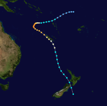
Tropical Cyclone Fergus
| Category 2 tropical cyclone (Australian scale) |
| Category 1 tropical cyclone (SSHWS) |
|
|
| Duration |
23 December – 25 December |
| Peak intensity |
110 km/h (70 mph) (10-min) 975 hPa (mbar) |
Fergus was a Category 2 storm that formed in the Pacific Ocean, lasting from 29 December to 31 December 1996 until becoming extratropical near New Zealand. The storm dropped heavy rainfall across an already saturated area, with totals of over 16.5 inches (425 mm) near Thames. The rainfall led to widespread flooding and forced many to evacuate. Severe road damage occurred, with some roads remaining closed for over a week. Gusty winds from Fergus downed trees and power lines, and caused property damage.[3]
Tropical Cyclone Phil
| Category 2 tropical cyclone (Australian scale) |
| Category 2 tropical cyclone (SSHWS) |
|
|
| Duration |
26 December – 3 January |
| Peak intensity |
110 km/h (70 mph) (10-min) 975 hPa (mbar) |
A weak cyclone, Phil crossed the northern part of Australia between 26 December and 27 December 1996. The storm then moved westward where it encountered vertical wind shear and dissipated on 31 December. It reformed on 9 January 1997 and finally dissipated on 12 January.
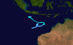
Severe Tropical Cyclone Rachel
| Category 3 severe tropical cyclone (Australian scale) |
| Category 1 tropical cyclone (SSHWS) |
|
|
| Duration |
2 January – 10 January |
| Peak intensity |
130 km/h (80 mph) (10-min) 965 hPa (mbar) |
The third and last cyclone to affect Western Australia, Cyclone Rachel formed on 3 January 1997. The storm reached Category 2 status as it moved southward. On 4 January the cyclone brushed Troughton Island and Kalumburu Community, Western Australia before making landfall in the north of the Kimberley region of Western Australia.
Rachel then swung back out to sea and hugged the coast before making a second landfall near Port Hedland. Moving inland the terran weakened the storm and Rachel dissipated on 8 January.
Severe Tropical Cyclone Drena
| Category 4 severe tropical cyclone (Australian scale) |
| Category 4 tropical cyclone (SSHWS) |
|
|
| Duration |
4 January – 6 January |
| Peak intensity |
170 km/h (105 mph) (10-min) 935 hPa (mbar) |
Cyclone Drena crossed from the South Pacific on 4 January with winds of 140 miles per hour. The storm again crossed out 2 days later.
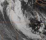
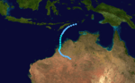
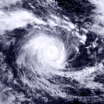
Severe Tropical Cyclone Pancho-Helinda
| Category 5 severe tropical cyclone (Australian scale) |
| Category 4 tropical cyclone (SSHWS) |
|
|
| Duration |
18 January – 22 January |
| Peak intensity |
205 km/h (125 mph) (10-min) 910 hPa (mbar) |
Pancho formed to the north of Cocos Islands during 20 January 1997. It moved south towards Cocos Islands, then moved southwest, intensifying rapidly to a Category 4 or Category 5 cyclone with an estimated central pressure of 925 hPa by the morning of 22 January. Pancho then was renamed Helinda by the Mauritiaun TCWC and weakened. By 29 January Pancho/Helinda was moving from the northwest towards Cocos Islands again, however again it changed direction to the southwest and reintensified to Category 4. It finally weakened to a tropical depression by 5 February.[4]
Tropical Cyclone Gillian
| Category 1 tropical cyclone (Australian scale) |
| Tropical storm (SSHWS) |
|
|
| Duration |
10 February – 12 February |
| Peak intensity |
75 km/h (45 mph) (10-min) 995 hPa (mbar) |
Tropical Cyclone Gillian existed from 10 February to 12 February.
Tropical Cyclone Harold
| Category 2 tropical cyclone (Australian scale) |
| Tropical storm (SSHWS) |
|
|
| Duration |
16 February – 21 February |
| Peak intensity |
100 km/h (65 mph) (10-min) 975 hPa (mbar) |
Tropical Cyclone Harold existed from 16 February to 21 February.
Tropical Cyclone Ita
| Category 1 tropical cyclone (Australian scale) |
| Tropical storm (SSHWS) |
|
|
| Duration |
23 February – 24 February |
| Peak intensity |
85 km/h (50 mph) (10-min) 996 hPa (mbar) |
Tropical Cyclone Ita existed from 23 February to 24 February.
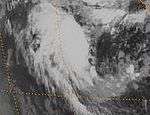
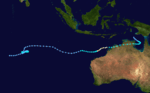
Tropical Cyclone Justin
| Category 3 severe tropical cyclone (Australian scale) |
| Category 2 tropical cyclone (SSHWS) |
|
|
| Duration |
3 March – 29 March |
| Peak intensity |
150 km/h (95 mph) (10-min) 955 hPa (mbar) |
Justin had a long 3½ week life in March 1997. Peaking as a Category 4 cyclone, and making landfall as a Category 2, it caused significant damage in the Cairns region which it approached on two occasions.It was the largest cyclone to hit Northern Queensland in 1997. Houses were undermined by huge waves, a marina and boats were severely damaged, roads and bridges suffered from flood and landslide damage and huge losses were inflicted on sugar cane, fruit and vegetable crops. The death toll in Queensland was seven including five on a yacht which sank. There were 26 who died in Papua New Guinea which was also severely affected. Total estimated costs in Australia were $190 million (1997 values).
Severe Tropical Cyclone Rhonda
| Category 4 severe tropical cyclone (Australian scale) |
| Category 3 tropical cyclone (SSHWS) |
|
|
| Duration |
10 May – 17 May |
| Peak intensity |
180 km/h (110 mph) (10-min) 935 hPa (mbar) |
This stormed formed in the southern Indian Ocean on 10 May 1997. It dissipated on 16 May.
Other storms
On October 15, TCWC Perth reported that a tropical low developed within a near equatorial trough of low pressure about x, to the southwest of X on the Indonesian island of Sumatra. Over the next few days, the low moved into the South-West Indian Ocean basin while developing further, before being named Antoinette by RSMC La Reunion during October 18.
Seasonal effects
See also
References
External links
|
|---|
|
| |
|
-
 Book Book
-
 Category Category
-
 Portal Portal
-
 WikiProject WikiProject
-
 Commons Commons
|