Cumberland River (Victoria)
| Cumberland | |
| River[1] | |
| Name origin: Duke of Cumberland; or the schooner Cumberland[2][3] | |
| Country | Australia |
|---|---|
| State | Victoria |
| Regions | South East Coastal Plain (IBRA), The Otways |
| Local government area | Surf Coast Shire, Colac Otway Shire |
| Part of | Corangamite catchment |
| Tributaries | |
| - left | Garvey Creek |
| Landmark | Great Ocean Road |
| Source | Otway Ranges |
| - location | south of Mount Cowley |
| - elevation | 532 m (1,745 ft) |
| - coordinates | 38°34′28″S 143°48′28″E / 38.57444°S 143.80778°E |
| Mouth | Bass Strait |
| - location | south of Lorne |
| - elevation | 0 m (0 ft) |
| - coordinates | 38°34′35″S 143°56′57″E / 38.57639°S 143.94917°ECoordinates: 38°34′35″S 143°56′57″E / 38.57639°S 143.94917°E |
| Length | 20 km (12 mi) |
| National park | Great Otway National Park |
| [1][4] | |
The Cumberland River is a perennial river of the Corangamite catchment, located in The Otways region of the Australian state of Victoria.
Location and features
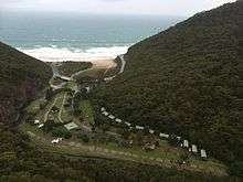
The Cumberland River rises south of Mount Cowley and south-east of the Benwerrin-Mount Sabine Road in the Otway Ranges in southwest Victoria and flows generally east before turning south just above popular short walk destination Jebbs Pool, between the high cliffs of Langdale Pike and Castle Rock, then along the cliff side of Cumberland River Holiday Park between The Brothers and Mount Defiance where the river reaches its mouth, crossing near the edge of a 200 metres (660 ft) sandy surf beach, and empties into Bass Strait, northeast of Wye River, Victoria and to the south of Lorne.[5] From its highest point, the river descends 532 metres (1,745 ft) over its 20-kilometre (12 mi) course.[6]
Etymology
The river was probably named by surveyor George Smythe in 1846, either for the Duke of Cumberland or for the schooner Cumberland in which Charles Grimes explored Port Phillip and King Island in 1802 - 03.[2][3]
See also

References
- 1 2 "Cumberland River: 3333". Vicnames. Government of Victoria. 2 May 1966. Retrieved 1 June 2014.
- 1 2 Blake, Les (1977), Place names of Victoria, Adelaide: Rigby, p. 294, ISBN 0-7270-0250-3
- 1 2 Bird, Eric (12 October 2006). "Place Names on the Coast of Victoria" (PDF) (PDF). Australian National Placename Survey (ANPS). Archived from the original (PDF) on 9 February 2011. Retrieved 10 February 2011.
- ↑ "Map of Cumberland River, VIC". Bonzle Digital Atlas of Australia. Retrieved 1 June 2014.
- ↑ VicmapTopo_25k_T6210-1-N via http://services.land.vic.gov.au/maps/imf/search/Topo30Front.jsp
- ↑ The River of Waterfalls, The Argus, 11 April 1914, p.5 via http://nla.gov.au/nla.news-article7246749?
External links
![]() Media related to Cumberland River (Victoria) at Wikimedia Commons
Media related to Cumberland River (Victoria) at Wikimedia Commons
- "Great Otway National Park". Parks Victoria. Government of Victoria. 2014.
- "Corangamite Catchment Management Authority". Government of Victoria. 2014. Archived from the original on 12 May 2014.
Rivers of the Corangamite catchment, Victoria, Australia | |
|---|---|
| |
|