Croscombe
| Croscombe | |
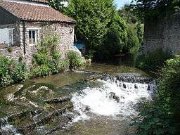 The course of the River Sheppey has been substantially 'managed' on its way through Croscombe, as this weir area demonstrates. The Sheppey was the main power source for many of the mills which operated in Croscombe in the 18th and 19th centuries. |
|
 Croscombe |
|
| Population | 603 (2011)[1] |
|---|---|
| OS grid reference | ST595445 |
| District | Mendip |
| Shire county | Somerset |
| Region | South West |
| Country | England |
| Sovereign state | United Kingdom |
| Post town | WELLS |
| Postcode district | BA5 |
| Dialling code | 01749 |
| Police | Avon and Somerset |
| Fire | Devon and Somerset |
| Ambulance | South Western |
| EU Parliament | South West England |
| UK Parliament | Wells |
Coordinates: 51°11′54″N 2°34′44″W / 51.1982°N 2.5789°W

Croscombe is a village and civil parish 2 miles (3 km) west of Shepton Mallet and 4 miles (6 km) from Wells, in the Mendip district of Somerset, England. It is situated on the A371 road in the valley of the River Sheppey.
Croscombe has a village hall, a shop, a public house, a Church, a chapel and a school.
History
North-east of the village and within the parish boundary is Maesbury Castle, an Iron Age hill fort.
It was first recorded in 706 when King Ine of Wessex referred to the village[2] as Correges Cumb. The parish of Croscombe was part of the Whitstone Hundred.[3] Croscombe emerged in the 16th and 17th centuries with a boom in the wool trade. During this period many houses, cottages and hostelries were built and the church was reconstructed.
During the Industrial Revolution, silk, mining, quarrying and milling replaced the wool trade. In 1848 the River Sheppey powered two mills for grinding corn, one for winding silk, and another used as a stocking manufactory.[4]
The Old Manor was built around 1460–89 as a rectorial manor house for Hugh Sugar, the Treasurer of Wells Cathedral. It was altered in the 16th and 18th centuries, and in the 20th century by the Landmark Trust.[5] It has been designated as a Grade I listed building.[6]
The village cross was put in place in the 19th century, replacing an older one which had been there since the 14th century. It is heavily weathered (the rock type is oolite - a soft limestone), especially on the front right where it serves as a seat for patrons of the adjacent The Cross.[7] The village's other public house is The George Inn.
Governance
The parish council has responsibility for local issues, including setting an annual precept (local rate) to cover the council’s operating costs and producing annual accounts for public scrutiny. The parish council evaluates local planning applications and works with the local police, district council officers, and neighbourhood watch groups on matters of crime, security, and traffic. The parish council's role also includes initiating projects for the maintenance and repair of parish facilities, as well as consulting with the district council on the maintenance, repair, and improvement of highways, drainage, footpaths, public transport, and street cleaning. Conservation matters (including trees and listed buildings) and environmental issues are also the responsibility of the council.
The village falls within the non-metropolitan district of Mendip, which was formed on 1 April 1974 under the Local Government Act 1972, having previously been part of Wells DistrictCouncil,[8] which is responsible for local planning and building control, local roads, council housing, environmental health, markets and fairs, refuse collection and recycling, cemeteries and crematoria, leisure services, parks and tourism.
Somerset County Council is responsible for running the largest and most expensive local services such as education, social services, libraries, main roads, public transport, policing and fire services, trading standards, waste disposal and strategic planning.
The village falls in the 'Croscombe and Pilton' electoral ward. The ward stretches from Croscombe in the north east to Pilton in the south. North Wootton is also included. The total parish population at the 2011 census was 2,284.[9]
It is also part of the Wells county constituency represented in the House of Commons of the Parliament of the United Kingdom. It elects one Member of Parliament (MP) by the first-past-the-post system of election and is part of the South West England constituency of the European Parliament which elects seven MEPs using the d'Hondt method of party-list proportional representation.
Religious sites


The large Church of St Mary the Virgin is of particular interest, having an unusual spire for Somerset, and Jacobean interior woodwork of national renown.[5] It is primarily from the 15th and 16th centuries with 19th-century restoration. It includes a peal of six bells, the earliest dated 1613, and an organ from 1837. It has been designated by English Heritage as a Grade I listed building.[10]
The Old Rectory (also known as Parsonage House) was built in the 17th century and rebuilt in the 18th. It is a Grade II listed building.[11] In 2014 it was announced by the Church Commissioners that the house would be purchased, for £900,000 as a residence for Peter Hancock the incoming Bishop of Bath and Wells as an alternative to living at the traditional Bishop's Palace in Wells, to provide him with more privacy.[12] This proposition was strongly opposed by the populace and eventually abandoned.The Rectory was resold.
References
- ↑ "Croscombe Parish". Neighbourhood Statistics. Office for National Statistics. Retrieved 1 January 2014.
- ↑ "Croscombe village website". Retrieved 17 March 2008.
- ↑ "Somerset Hundreds". GENUKI. Retrieved 22 October 2011.
- ↑ "Croscombe (St Mary)". British History Online. Retrieved 14 September 2007.
- 1 2 Scott, Shane (1995). The hidden places of Somerset. Aldermaston: Travel Publishing Ltd. p. 63. ISBN 1-902007-01-8.
- ↑ "The Old Manor". Images of England. English Heritage. Retrieved 19 May 2009.
- ↑ "Village Cross adjacent to The Cross". Images of England. Retrieved 17 March 2008.
- ↑ "Shepton Mallet RD". A vision of Britain Through Time. University of Portsmouth. Retrieved 4 January 2014.
- ↑ "Croscombe and Pilton ward 2011.Retrieved 7 March 2015".
- ↑ "Church of St Mary the Virgin". Images of England. Retrieved 17 March 2008.
- ↑ "Parsonage House". National Heritage List for England. English Heritage. Retrieved 31 January 2014.
- ↑ "Bishop of Bath and Wells to swap Wells palace for Georgian rectory in Croscombe". Western Daily Press. 24 January 2014. Retrieved 31 January 2014.
External links
![]() Media related to Croscombe at Wikimedia Commons
Media related to Croscombe at Wikimedia Commons