Selwood, Somerset
| Selwood | |
 Selwood Academy School |
|
 Selwood |
|
| Population | 798 (2011)[1] |
|---|---|
| OS grid reference | ST787486 |
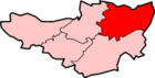
| District | Mendip |
| Shire county | Somerset |
| Region | South West |
| Country | England |
| Sovereign state | United Kingdom |
| Post town | FROME |
| Postcode district | BA11 0 |
| Dialling code | 01373 |
| Police | Avon and Somerset |
| Fire | Devon and Somerset |
| Ambulance | South Western |
| EU Parliament | South West England |
| UK Parliament | Somerton and Frome |
Coordinates: 51°14′12″N 2°18′21″W / 51.2366°N 2.3057°W
Selwood used to be a village but is now part of the suburbs of Frome. It is a civil parish in the Mendip district of Somerset, England. The parish includes the villages of East and West Woodlands, Rodden and the hamlets of Alder Row and Blatchbridge.
History
The name Selwood is first recorded in Old English around 894 as Seluudu which some etymologists consider to derive from Sealhwudu or Sallow wood.
Roddenbury Hillfort is a univallate Iron Age hill fort. It is a Scheduled Ancient Monument[2] and on the Heritage at Risk register.[3]
Selwood Forest is an area of woodland on the borders between Somerset, Dorset and Wiltshire in south west England. In Anglo-Saxon times it was far more substantial and covered a much greater area forming a natural barrier between the Anglo-Saxons of Wessex and the Britons of Dumnonia and the Severn Valley. It was also the site of Hales Castle.
The parish was part of the hundred of Frome.[4]
Governance
The parish council has responsibility for local issues, including setting an annual precept (local rate) to cover the council's operating costs and producing annual accounts for public scrutiny. The parish council evaluates local planning applications and works with the local police, district council officers, and neighbourhood watch groups on matters of crime, security, and traffic. The parish council's role also includes initiating projects for the maintenance and repair of parish facilities, as well as consulting with the district council on the maintenance, repair, and improvement of highways, drainage, footpaths, public transport, and street cleaning. Conservation matters (including trees and listed buildings) and environmental issues are also the responsibility of the council.
The village falls within the Non-metropolitan district of Mendip, which was formed on 1 April 1974 under the Local Government Act 1972, having previously been part of Frome Rural District,[5] which is responsible for local planning and building control, local roads, council housing, environmental health, markets and fairs, refuse collection and recycling, cemeteries and crematoria, leisure services, parks, and tourism.
Somerset County Council is responsible for running the largest and most expensive local services such as education, social services, libraries, main roads, public transport, policing and fire services, trading standards, waste disposal and strategic planning.
It is also part of the Somerton and Frome county constituency represented in the House of Commons of the Parliament of the United Kingdom. It elects one Member of Parliament (MP) by the first past the post system of election, and part of the South West England constituency of the European Parliament which elects seven MEPs using the d'Hondt method of party-list proportional representation.
Landmarks
Manor Farmhouse in West Woodlands provides a particularly good survival of 17th century interior features in a very fine state of preservation,[6] while St. Algars Farmhouse (named after Ælfgar of Selwood) dates from the 14th century.[7] In Rodden the Manor House dates from the late 16th century.[8]
Religious sites
The Church of All Saints in Rodden dates from 1640, and was rebuilt in the mid 19th century.[9]
The church in East Woodlands was completed in 1714 having been paid for by the Longleat estate, then patrons of the parish. It is now dedicated to St Katharine. It was extensively restored in the 1870s by Pearson,[10] the architect who also designed Truro Cathedral.
References
- ↑ "Selwood Parish". Neighbourhood Statistics. Office for National Statistics. Retrieved 1 January 2014.
- ↑ "Roddenbury Hillfort, Longleat Wood, Selwood". Somerset Historic Environment Record. Somerset County Council. Retrieved 15 January 2011.
- ↑ "Hillfort on Roddenbury Hill". Heritage at Risk. English Heritage. Retrieved 10 February 2011.
- ↑ "Somerset Hundreds". GENUKI. Retrieved 8 October 2011.
- ↑ "Frome RD". A vision of Britain Through Time. University of Portsmouth. Retrieved 4 January 2014.
- ↑ "Manor Farmhouse, West Woodlands". Images of England. English Heritage. Retrieved 28 January 2009.
- ↑ "St. Algars Farmhouse". Images of England. English Heritage. Retrieved 28 January 2009.
- ↑ "Manor Farmhouse". Images of England. English Heritage. Retrieved 28 January 2009.
- ↑ "Church of All Saints". Images of England. English Heritage. Retrieved 28 January 2009.
- ↑ "Church of St. Katherine". Images of England. English Heritage. Retrieved 28 January 2009.
External links
| Wikimedia Commons has media related to Selwood, Somerset. |