Crookstown
| Crookstown An Baile Gallda | |
|---|---|
| Town | |
 Crookstown Location in Ireland | |
| Coordinates: 53°01′11″N 6°48′10″W / 53.019722°N 6.802778°WCoordinates: 53°01′11″N 6°48′10″W / 53.019722°N 6.802778°W | |
| Country | Ireland |
| Province | Leinster |
| County | County Kildare |
| Elevation | 100 m (300 ft) |
| Time zone | WET (UTC+0) |
| • Summer (DST) | IST (WEST) (UTC-1) |
| Irish Grid Reference | S797969 |
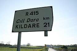
Crookstown (Irish: An Baile Gallda, meaning "town of the invader or foreigner") is a small town in the south of County Kildare, Ireland. It is on the former N9 road (now by-passed) where it meets the R415 regional road, about 75 km (47 mi) south of Dublin. It is a small town, with only a few hundred inhabitants but has a church, a primary school, a petrol station/rest area on the N9, restaurant and small hotel and also some craft shops. It is only a kilometre from the larger neighbouring village of Ballitore and the two villages are almost merged.
Public transport
The village is served by bus route 880 operated by Kildare Local Link on behalf of the National Transport Authority. There are several buses each day including Sunday linking the village to Castledermot, Carlow and Naas as well as villages such as Moone in the area.[1]
See also