Inveresk Roman Fort
| Inveresk Roman Fort | |
|---|---|
|
Inveresk Parish Kirk, site of the Roman Fort | |
 | |
| Structure | |
| — Stone? structure — | |
| Size and area | (2.7 ha) |
| Location | |
| Coordinates | 55°56′11″N 3°03′17″W / 55.9365°N 3.0546°W |
| Place name | Inveresk |
| County | East Lothian |
| Country | Scotland |
| Reference | |
| UK-OSNG reference | NT345722 |
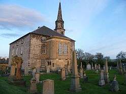
Inveresk Roman Fort is an archaeological site within the grounds of St Michael's Church, Inveresk, a village in East Lothian, Scotland. Several seasons of excavation since 1946, both major and minor, have established the outline of the fort and recovered some of the interior detail.[1][2]
The fort covered an area of 6.6 acres (2.7 ha), placing it at the larger end of the spectrum of fort sizes.[3] For this reason, the original excavator, Ian Richmond, believed that a cavalry regiment had been stationed here. Little is known of the interior buildings, so this hypothesis cannot yet be tested. In 2007 a Roman tombstone was found at nearby Carberry depicting a Roman Governor's guard cavalry trooper named "Crescens" who was perhaps residing at the fort when he died.[4][5]
All of the datable artefacts point to Antonine occupation.[6] Consequently, the fort is thought to have been established in the immediate aftermath of the invasion of Scotland launched by the emperor Antoninus Pius in AD 139/140. Two clear phases of occupation were identified archaeologically, perhaps occasioned by a change of garrison during the Antonine period. The fort will have been abandoned, along with the other Scottish sites, around AD 160, when Hadrian's Wall was recommissioned.
A substantial civil settlement (vicus) lay outside the east rampart of the fort, and included a curving structure thought to be an amphitheatre.[7]
The fort's Roman name remains unknown, although it has been suggested that Ptolemy's Κούρια (Curia or Coria), located in the lands of the Votadini,[8] should be identified with Inveresk, "the name being transferred from a native meeting-place which it controlled (in this case perhaps Arthur's Seat, 4 miles to the west)".[9] It may also have been called "Evidensca" according to the Ravenna Cosmography.[10][11]
Notes
- ↑ Richmond, Ian A. (1980). "A Roman fort at Inveresk, Midlothian" (PDF). Proceedings of the Society of Antiquaries of Scotland. 110: 286–304.
- ↑ Leslie, A. (2002). "The Roman fort at Inveresk". In Bishop, M. C. (ed.). Roman Inveresk: Past, Present and Future. Duns: The Armatura Press. pp. 17–28.
- ↑ Duncan B. Campbell, Roman Auxiliary Forts 27 BC-AD 378 (Oxford: Osprey, 2009), pp. 28-32, on the sizes of auxiliary forts.
- ↑ Tomlin, R.S.O. (2008). "Roman Britain in 2007. III. Inscriptions". Britannia. 39: 369–390. doi:10.3815/006811308785916908. Inscription no. 5, pp. 372-4 and fig. 5.
- ↑ "Roman tombstone found at Inveresk". BBC News. 29 October 2007.
- ↑ e.g. J.P. Gillam's report on "The Coarse Pottery", in Richmond, op. cit., pp. 300-302, concluding that "taken as a whole, the group [of pottery] is early Antonine; ... there are no Flavian pieces"; cf. Grace Simpson, "The Decorated Samian Pottery", in Richmond, op. cit., pp. 302-303, dating the three available sherds to "c AD 138-165".
- ↑ T. Neighbour, "Excavations on the 'amphitheatre' and other areas east of Inveresk fort", in: M.C. Bishop (ed.), Roman Inveresk: Past, Present and Future (Duns: The Armatura Press, 2002), pp. 41-51.
- ↑ Ptol., Geog. II, 3, 7; also found in the Ravenna Cosmography (107.41) as CORITIOTAR, which is thought to be a corruption of Coria Votad(inorum)
- ↑ A.L.F. Rivet & Colin Smith, The Place-names of Roman Britain (London: B.T. Batsford Ltd., 1979), p. 320, s.v. CORIA of the Votadini
- ↑ http://www.romanmap.com/htm/ravcosm/rc159-189.htm
- ↑ http://www.romanmap.com/htm/nomina/Eiudens.htm
References
- M.C. Bishop (ed.), Roman Inveresk: Past, Present and Future (Duns: The Armatura Press, 2002)