Cordova, Cebu
| Cordova | |
|---|---|
| Municipality | |
|
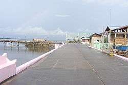
View along Day-As boardwalk | |
 Map of Cebu with Cordova highlighted | |
.svg.png) Cordova Location within the Philippines | |
| Coordinates: 10°15′N 123°57′E / 10.25°N 123.95°ECoordinates: 10°15′N 123°57′E / 10.25°N 123.95°E | |
| Country | Philippines |
| Region | Central Visayas (Region VII) |
| Province | Cebu |
| District | 6th district of Cebu |
| Founded | 1960 |
| Barangay | 13 (see § Barangays) |
| Government [1] | |
| • Type | Sangguniang Bayan |
| • Mayor | Teche Cho (LP) |
| • Vice mayor | Adelino Sitoy |
| • Town Council |
Members
|
| • Representative | Jonas Cortes |
| Areanscb[2] | |
| • Total | 17.15 km2 (6.62 sq mi) |
| • Land | 7.90 km2 (3.05 sq mi) |
| Highest elevation | 10 m (30 ft) |
| Population (2015 census)[3] | |
| • Total | 59,712 |
| • Density | 7,600/km2 (20,000/sq mi) |
| • Voter (2016)[4] | 34,273 |
| Demonym(s) | Cordovanhon |
| Time zone | PST (UTC+8) |
| ZIP code | 6017 |
| IDD : area code | +63 (0)32 |
| Income class | 3rd class |
| PSGC | nscb |
| Website |
cordova |
Cordova (also spelled Cordoba) is a 3rd municipal income class municipality in the province of Cebu, Philippines.[5] Most of Cordova lies on separate islands off the southern coast of Mactan Island. It is connected to the main island of Mactan by two bridges with a third to be opened by 2020.[6][7]
According to the 2015 census, it has a population of 59,712.[3] In the 2016 election, it had 34,273 registered voters.[4]
History
Cordova is not the original name of the territory it represents, and neither is it named for the city of Cordoba, Spain. On 22 May 1863, Governor General Rafael Echague created a new town comprising the barrios of Gabi, Day‑as and Pilipul (now called Pilipog), all of which are located on the southeastern tip of Mactan Island. He chose the name Cordoba which means "stark nakedness and bare".
Cordova became a municipality in 1864, and from 1913 up to the present, a total of 15 mayors governed the district.
Geography
Geographically, Cordova consists of a main island, bordering on and separated from Mactan Island by a narrow stream, as well as the islets of Gilutongan (also spelled Hilutungan), Nalusuan, Shell, Tongo and Lava. The two islets of Gilutongan and Nalusuan are part of the Olango Island Group in the middle of the Cebu Strait. Its land area is 789.6 hectares (1,951 acres), of which 740.85 hectares (1,830.7 acres) constitutes the main island and 48.75 hectares (120.5 acres) are outlying islets.[2]
The surface of the town consists entirely of karstic limestone rock geologically associated with the Plio-Pleistocene Carcar Formation, dated to 2½–3 million years ago. The topography of Cordova is flat land, the highest point being only 10 metres (33 ft) above sea level.[2]
Climate
| Corbova Average annual temperature in Corbova is 27·6°C Humidity 75–85% | ||||||||||||||||||||||||||||||||||||||||||||||||||||||||||||
|---|---|---|---|---|---|---|---|---|---|---|---|---|---|---|---|---|---|---|---|---|---|---|---|---|---|---|---|---|---|---|---|---|---|---|---|---|---|---|---|---|---|---|---|---|---|---|---|---|---|---|---|---|---|---|---|---|---|---|---|---|
| Climate chart (explanation) | ||||||||||||||||||||||||||||||||||||||||||||||||||||||||||||
| ||||||||||||||||||||||||||||||||||||||||||||||||||||||||||||
| ||||||||||||||||||||||||||||||||||||||||||||||||||||||||||||
The climate of Cordova is of Coronas type III, meaning the seasons are not very pronounced and are classified as hot and humid.
Its temperature ranges from 18 to 35 °C (65 to 95 °F), with a mean high temperature of 31 °C (88 °F) and a mean low of 23 °C (74 °F).[2]
Barangays
Cordova comprises 13 barangays:[5]
| PSGC | Barangay | Population | ±% p.a. | ||
|---|---|---|---|---|---|
| 2015[3] | 2010[8] | ||||
| 072220001 | Alegria | 5.9% | 3,540 | 2,874 | +4.05% |
| 072220002 | Bangbang | 8.9% | 5,287 | 4,325 | +3.90% |
| 072220003 | Buagsong | 6.6% | 3,936 | 3,350 | +3.12% |
| 072220004 | Catarman | 7.7% | 4,596 | 3,741 | +4.00% |
| 072220005 | Cogon | 4.5% | 2,715 | 2,585 | +0.94% |
| 072220006 | Dapitan | 5.3% | 3,149 | 2,993 | +0.97% |
| 072220007 | Day‑as | 7.1% | 4,241 | 3,617 | +3.08% |
| 072220008 | Gabi | 7.9% | 4,713 | 3,478 | +5.96% |
| 072220009 | Gilutongan[9] | 2.7% | 1,640 | 1,442 | +2.48% |
| 072220010 | Ibabao | 14.0% | 8,355 | 6,949 | +3.57% |
| 072220011 | Pilipog | 7.2% | 4,273 | 3,642 | +3.09% |
| 072220012 | Poblacion | 16.1% | 9,625 | 8,603 | +2.16% |
| 072220013 | San Miguel | 6.1% | 3,642 | 2,754 | +5.47% |
| Total | 59,712 | 50,353 | +3.30% | ||
Demographics
| Population census of Cordova | |||||||||||||||||||||||||||||||
|---|---|---|---|---|---|---|---|---|---|---|---|---|---|---|---|---|---|---|---|---|---|---|---|---|---|---|---|---|---|---|---|
|
| ||||||||||||||||||||||||||||||
| Source: Philippine Statistics Office[3][8][10] | |||||||||||||||||||||||||||||||
In the 2016 election, it had 34,273 registered voters, meaning that 57% of the population are aged 18 and over.[4]
Tourism
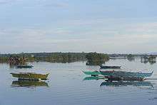
Cordova has six hotels and resorts, while some tourist areas include:
- Gilutongan Marine Sanctuary
- Nalusuan Marine Sanctuary
- Day‑as Boardwalk and Marine Park
- Kamampay Public Beach
A special attraction is the mangrove forest and swamp area. The best access to this area is the Day-as Boardwalk and Marine Park. The total mangrove plantation is estimated to cover more or less one hundred hectares (250 acres). Most of the mangrove forest is located in the barangays of Pilipog, Bangbang, San Miguel, Day‑as and Catarman.
Education
The children in Cordova are served by 14 day-care centers, eleven public elementary schools, two private elementary schools, one public high school, a private high school and the public college. Educational achievement is relatively high, with 75% of adults (i.e. 21 years old and above) having finished elementary and high school and 23% have attended university or received a degree. Around 2% of the population report not having received formal schooling.
See also
Notes
References
- ↑ "Municipality". Quezon City, Philippines: Department of the Interior and Local Government. Retrieved 31 May 2013.
- 1 2 3 4 "Physical Profile". www.cordova.gov.ph. Municipality of Cordova. 2016. Retrieved 25 February 2016.
- 1 2 3 4 "Region VII (CENTRAL VISAYAS)". Census of Population (2015): Total Population by Province, City, Municipality and Barangay (Report). PSA. Retrieved 20 June 2016.
- 1 2 3 "2016 National and Local Elections Statistics". Commission on Elections. 2016.
- 1 2
- ↑ Cebu Daily News 2016.
- ↑ Philippine Star 2016.
- 1 2 "Region VII (CENTRAL VISAYAS)". Census of Population and Housing (2010): Total Population by Province, City, Municipality and Barangay (Report). NSO. Retrieved 29 June 2016.
- ↑ Sotto et al. 2001.
- ↑ "Region VII (CENTRAL VISAYAS)". Census of Population (1995, 2000 and 2007): Total Population by Province, City and Municipality (Report). NSO. Archived from the original on 24 June 2011.
Sources
- Cebu Daily News, Jessie D. Campos (27 January 2016). "Cordova, Metro Pacific ink deal for 3rd Mactan bridge". Archived from the original on 2016-01-20.
- Gonzales, Glenda R. (December 2004). "Metro Cebu: A Metropolitan Area in Need of Coordinative Body" (PDF). DISCUSSION PAPER. 2004-49. Philippine Institute for Development Studies. Archived (PDF) from the original on 2016-03-10. Retrieved 16 February 2016.
- Philippine Star, Marieta Reyes (2 May 2016). "Cebu-Cordova bridge to boost Central Visayas economy". Archived from the original on 2 May 2016.
- Sotto, Filipina; Gatus, Joey; Ross, Michael; Portigo, Ma Fe; Freire, Francis (2001). "Coastal Environmental Profile of Olango Island, Cebu, Philippines" (PDF). ISBN 971-9229012.
External links
| Wikivoyage has a travel guide for Cordova. |
 |
Lapu–Lapu | | ||
| Mactan Channel | |
Cebu Strait | ||
| ||||
| | ||||
| Cebu Strait |
Cebu City (capital) | |
| Municipalities |
|
| Component cities | |
| Highly urbanized cities | (Administratively independent from the province but grouped under Cebu by the Philippine Statistics Authority. Mandaue is grouped under the 6th legislative district of Cebu but still independent from the province.) |