Cooperstown Township, Brown County, Illinois
| Cooperstown Township | |
|---|---|
| Township | |
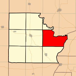 Location in Brown County | |
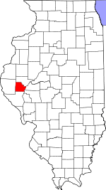 Brown County's location in Illinois | |
| Coordinates: 39°57′48″N 90°36′55″W / 39.96333°N 90.61528°WCoordinates: 39°57′48″N 90°36′55″W / 39.96333°N 90.61528°W | |
| Country | United States |
| State | Illinois |
| County | Brown |
| Established | November 8, 1853 |
| Area | |
| • Total | 41.45 sq mi (107.4 km2) |
| • Land | 40.67 sq mi (105.3 km2) |
| • Water | 0.78 sq mi (2.0 km2) 1.88% |
| Elevation | 627 ft (191 m) |
| Population (2010) | |
| • Total | 311 |
| • Density | 7.6/sq mi (2.9/km2) |
| Time zone | CST (UTC-6) |
| • Summer (DST) | CDT (UTC-5) |
| ZIP codes | 62353, 62378 |
| GNIS feature ID | 0428841 |
Cooperstown Township is one of nine townships in Brown County, Illinois, USA. As of the 2010 census, its population was 311 and it contained 162 housing units.[1]
Geography
According to the 2010 census, the township has a total area of 41.45 square miles (107.4 km2), of which 40.67 square miles (105.3 km2) (or 98.12%) is land and 0.78 square miles (2.0 km2) (or 1.88%) is water.[1]
Unincorporated towns
Cemeteries
The township contains these eleven cemeteries: Cooperstown, Cross Roads, De Witt, Elias Clark, Huffman, Hulett, Logan Creek, Logsdon Number 1, Logsdon Number 2, Perry and Tebo Burial Ground.
Major highways
Lakes
- Big Lake
School districts
- Brown County Community Unit School District 1
Political districts
- Illinois' 18th congressional district
- State House District 93
- State Senate District 47
References
- "Cooperstown Township, Brown County, Illinois". Geographic Names Information System. United States Geological Survey. Retrieved 2010-01-04.
- United States Census Bureau 2007 TIGER/Line Shapefiles
- United States National Atlas
- 1 2 "Population, Housing Units, Area, and Density: 2010 - County -- County Subdivision and Place -- 2010 Census Summary File 1". United States Census. Retrieved 2013-05-28.
External links

Municipalities and communities of Brown County, Illinois, United States | ||
|---|---|---|
| Cities | ||
| Villages | ||
| Townships | ||
| Unincorporated communities | ||
| Ghost towns | ||
This article is issued from Wikipedia - version of the 11/30/2016. The text is available under the Creative Commons Attribution/Share Alike but additional terms may apply for the media files.