Colorado State Highway 86
| ||||
|---|---|---|---|---|
 | ||||
| Route information | ||||
| Maintained by CDOT | ||||
| Length: | 61.47 mi[1] (98.93 km) | |||
| Major junctions | ||||
| West end: |
| |||
|
| ||||
| East end: |
| |||
| Location | ||||
| Counties: | Douglas, Elbert | |||
| Highway system | ||||
|
Colorado State Highways
| ||||

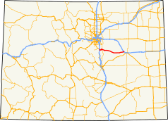
State Highway 86 is a state highway that runs from the US 85 interchange in Castle Rock just before I-25 to I-70 near Limon. It gives service through eastern Castle Rock to Franktown and then to Elizabeth then from Kiowa to I-70 (Exit 352).
Route description
The route begins at U.S. Highway 85 in Castle Rock, where it begins eastward. The route then interchanges with Interstate 25 before exiting town and entering Franktown where it meets State Highway 83. It then crosses the county line into Elbert, where it meets many county roads in various towns before meeting its east end at Interstate 70.[1]
History
The route was established in 1920s, when it began at U.S. Highway 85 at Castle Rock. The route then moved eastward along CR 118 to U.S. Highway 40. In the 1960s, the eastward routing was changed so it follows its current routing. By 1954, the route was paved to Kiowa from US 85 by 1954 and to its entirety by 1972. Following the construction of Interstate 25, the terminus became a business loop of I-25; however, the business loop was deleted in the 1990s, leaving SH 86's terminus at a local road. However, SH 86's terminus was rerouted to US 85 in 2006.[2]
Major intersections
| County | Location | mi[3] | km | Destinations | Notes |
|---|---|---|---|---|---|
| Douglas | Castle Rock | 0 | 0.0 | Western terminus; I-25/US 87 exit 184 | |
| Franktown | 8 | 13 | |||
| Elbert | | 61.5 | 99.0 | Eastern terminus; I-70/US 40, exit 352 | |
| 1.000 mi = 1.609 km; 1.000 km = 0.621 mi | |||||
References
- 1 2 "Segment list for SH 86". Retrieved 2007-05-12.
- ↑ Salek, Matthew E. "Colorado Routes 80-99". Retrieved 2010-05-26.
- ↑ "Highway Data Explorer". Colorado Department of Transportation. Retrieved November 20, 2014.