Clearing House, California
For other uses of this term, see Clearing house
| Clearing House | |
|---|---|
| Unincorporated community | |
 Clearing House  Clearing House Location in California | |
| Coordinates: 37°39′54″N 119°52′03″W / 37.66500°N 119.86750°WCoordinates: 37°39′54″N 119°52′03″W / 37.66500°N 119.86750°W | |
| Country | United States |
| State | California |
| County | Mariposa County |
| Elevation[1] | 1,555 ft (474 m) |
Clearing House (formerly, Clearinghouse) is an unincorporated community in Mariposa County, California.[1] It is located on the north bank of the Merced River 5 miles (8 km) west of El Portal,[2] at an elevation of 1555 feet (474 m).[1]
The Clearinghouse post office operated from 1913 to 1933.[2] The place name comes from the Clearinghouse Mine, so named as it was an exchange place for gold bullion and certificates during the Panic of 1907.[2] Clearing House has been noted for its unusual place name.[3]
References
- 1 2 3 U.S. Geological Survey Geographic Names Information System: Clearing House, California
- 1 2 3 Durham, David L. (1998). California's Geographic Names: A Gazetteer of Historic and Modern Names of the State. Clovis, Calif.: Word Dancer Press. p. 759. ISBN 1-884995-14-4.
- ↑ Thompson, George E. (1 July 2009). You Live Where?: Interesting and Unusual Facts about where We Live. iUniverse. p. 10. ISBN 978-1-4401-3421-0.
Municipalities and communities of Mariposa County, California, United States | ||
|---|---|---|
| CDPs | 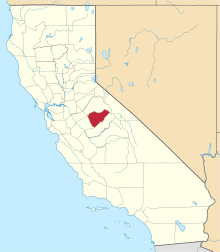 | |
| Unincorporated communities | ||
| Former settlements | ||
This article is issued from Wikipedia - version of the 9/27/2016. The text is available under the Creative Commons Attribution/Share Alike but additional terms may apply for the media files.