Civray, Cher
| Civray | ||
|---|---|---|
|
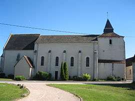
The church in Civray | ||
| ||
 Civray | ||
|
Location within Centre-Val de Loire region  Civray | ||
| Coordinates: 46°58′05″N 2°10′30″E / 46.9681°N 2.175°ECoordinates: 46°58′05″N 2°10′30″E / 46.9681°N 2.175°E | ||
| Country | France | |
| Region | Centre-Val de Loire | |
| Department | Cher | |
| Arrondissement | Bourges | |
| Canton | Chârost | |
| Intercommunality | Fercher - Pays florentais | |
| Government | ||
| • Mayor (2008–2014) | Serge Jeanzac | |
| Area1 | 40.87 km2 (15.78 sq mi) | |
| Population (2008)2 | 994 | |
| • Density | 24/km2 (63/sq mi) | |
| Time zone | CET (UTC+1) | |
| • Summer (DST) | CEST (UTC+2) | |
| INSEE/Postal code | 18066 / 18290 | |
| Elevation |
125–162 m (410–531 ft) (avg. 155 m or 509 ft) | |
|
1 French Land Register data, which excludes lakes, ponds, glaciers > 1 km² (0.386 sq mi or 247 acres) and river estuaries. 2 Population without double counting: residents of multiple communes (e.g., students and military personnel) only counted once. | ||
.svg.png)
Civray is a commune in the Cher department in the Centre region of France.
Geography
A farming area comprising the village and several hamlets situated in the valley of the river Pontet some 15 miles (24 km) southwest of Bourges at the junction of the N151 with the D88, D184 and D84 roads.
Population
| Historical population | ||
|---|---|---|
| Year | Pop. | ±% |
| 1962 | 832 | — |
| 1968 | 893 | +7.3% |
| 1975 | 840 | −5.9% |
| 1982 | 813 | −3.2% |
| 1990 | 1,023 | +25.8% |
| 1999 | 1,004 | −1.9% |
| 2008 | 994 | −1.0% |
Sights
- The church of St. Pierre, dating from the twelfth century.
- Traces of a medieval castle.
See also
References
External links
| Wikimedia Commons has media related to Civray (Cher). |
- Civray on the Quid website (French)
- INSEE
This article is issued from Wikipedia - version of the 7/10/2016. The text is available under the Creative Commons Attribution/Share Alike but additional terms may apply for the media files.