City of Collingwood
| City of Collingwood Victoria | |||||||||||||
|---|---|---|---|---|---|---|---|---|---|---|---|---|---|
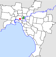 Location in Melbourne | |||||||||||||
| Population | 14,000 (1992)[1] | ||||||||||||
| • Density | 3,130/km2 (8,090/sq mi) | ||||||||||||
| Established | 1855 | ||||||||||||
| Area | 4.48 km2 (1.7 sq mi) | ||||||||||||
| Council seat | Collingwood | ||||||||||||
| Region | Melbourne | ||||||||||||
| County | Bourke | ||||||||||||
 | |||||||||||||
The City of Collingwood was a local government area located about 3 kilometres (2 mi) east-northeast of Melbourne, the state capital of Victoria, Australia. The city covered an area of 4.48 square kilometres (1.73 sq mi), and existed from 1855 until 1994.
History
Collingwood was first incorporated as a district on 24 April 1855, having split from the City of Melbourne on the same day as the neighbouring City of Richmond. It was split into two boroughs — Collingwood and East Collingwood — in 1863, which became towns on 23 May 1873 and 21 April 1873 respectively. They recombined into the City of Collingwood on 14 January 1876.[2]
On 22 June 1994, the City of Collingwood was abolished, and, along with the Cities of Fitzroy and Richmond and parts of Fairfield and Alphington, from the City of Northcote, was merged into the newly created City of Yarra.[3]
Council meetings were held at the Collingwood Town Hall, on Hoddle Street, Abbotsford.
Mayors
Wards
The City of Collingwood was divided into three wards on 31 May 1887, each electing three councillors:
- Abbotsford Ward
- Clifton Hill Ward
- Collingwood Ward
Suburbs
Population
| Year | Population |
|---|---|
| 1857 | 10,786 |
| 1881 | 23,829 |
| 1921 | 34,239 |
| 1954 | 27,155 |
| 1958 | 26,000* |
| 1961 | 25,413 |
| 1966 | 22,447 |
| 1971 | 21,022 |
| 1976 | 16,645 |
| 1981 | 15,089 |
| 1986 | 13,340 |
| 1991 | 13,388 |
* Estimate in the 1958 Victorian Year Book.
References
- ↑ Australian Bureau of Statistics, Victoria Office (1994). Victorian Year Book. p. 49. ISSN 0067-1223.
- ↑ Victorian Municipal Directory. Brunswick: Arnall & Jackson. 1992. pp. 351–352. Also consulted p.231 of the 1915 edition of same. Accessed at State Library of Victoria, La Trobe Reading Room.
- ↑ Australian Bureau of Statistics (1 August 1995). Victorian local government amalgamations 1994-1995: Changes to the Australian Standard Geographical Classification (PDF). Commonwealth of Australia. p. 12. ISBN 0-642-23117-6. Retrieved 2007-12-16.
Coordinates: 37°48′11″S 144°59′17″E / 37.803°S 144.988°E