City Park, Saskatoon
| City Park | |
|---|---|
| Neighbourhood | |
|
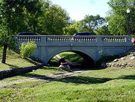
Spadina Crescent Bridge | |
 City Park location map | |
| Coordinates: 52°8′8″N 106°39′12″W / 52.13556°N 106.65333°WCoordinates: 52°8′8″N 106°39′12″W / 52.13556°N 106.65333°W | |
| Country |
|
| Province |
|
| City | Saskatoon |
| Suburban Development Area | Core Neighbourhoods |
| Neighbourhood | City Park |
| Construction | 1946-1960 |
| Government | |
| • Type | Municipal (Ward 1) |
| • Administrative body | Saskatoon City Council |
| • Councillor | Darren Hill |
| Area | |
| • Total | 1.39 km2 (0.54 sq mi) |
| Population (2009) | |
| • Total | 4,405 |
| • Density | 3,200/km2 (8,200/sq mi) |
| • Average Income | $42,236 |
| Time zone | CST (UTC-6) |
| Website | City Park Community Association |
City Park is a mixed-use neighbourhood located near the center of Saskatoon, Saskatchewan, Canada. It comprises a mix of single-family detached homes, apartment buildings and other semi-detached dwellings. It also contains a number of commercial zones with businesses. As of 2009, the area was home to 4,405 residents. The neighbourhood is considered a middle-income area, with an average family income of $42,236, an average dwelling value of $245,254 and a home ownership rate of 28.6%.[1] According to MLS data, the average sale price of a home as of 2013 was $305,157.[2]
History
City Park was originally known as Central Park and first had a golf course. In 1903, the annual exhibition was moved from the Louise Grounds in Nutana to City Park, and a horse racing track and grandstand were constructed. By 1910, the exhibition had moved to its permanent home in the city's south end.[3] The outline of the old racetrack can still be seen in what is now Kinsmen Park.
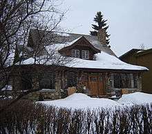
City Park was one of the first areas annexed by the city after its incorporation in 1906.[4] The Alexander Residence, built in 1912 on Spadina Crescent, was named for Dr. Harold E. and Edith Alexander, who owned the house from 1916 to 1946. It is one of the city's most notable examples of pre-World War I Arts and Crafts architecture.[5] It was designated a municipal heritage property on May 12, 2001.[6]
Government and politics
City Park exists within the federal electoral district of Saskatoon—Wanuskewin. Provincially, the area overlaps two separate constituencies:
- Saskatoon Centre - south of Queen Street. It is currently represented by David Forbes of the Saskatchewan New Democratic Party, first elected in 2001 and re-elected in 2003, 2007 and 2011.
- Saskatoon Meewasin - north of Queen Street. It is currently represented by Roger Parent of the Saskatchewan Party, first elected in 2011.
In Saskatoon's non-partisan municipal politics, City Park lies within Ward 1.
Institutions
Education
- City Park Collegiate - public secondary school and part of the Saskatoon Public School Division. Originally opened in 1929,[7] it was re-established in 1986 as an alternative high school for students who have difficulty in the regular school setting.[8]
Health
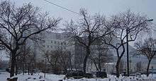
- Saskatoon City Hospital - originally opened in 1909 as western Canada's first municipal hospital. The original building was on 6th Avenue North; by 1927 a larger facility was built at the present site on Queen Street. It was expanded in 1930 and again in 1950. In the 1990s, part of the hospital was demolished and replaced the current building, completed in 1993. The hospital offers full acute care services, surgical facilities, and other specialized services. Unlike Saskatoon's other two hospitals, Royal University Hospital and St. Paul's Hospital, the emergency department of City Hospital is not open 24 hours a day.[9]
Parks and recreation
- Wilson Park - 6.4 acres (2.6 ha)
- Mendel Site Park - 8.3 acres (3.4 ha)
- Meewasin Park - 9.3 acres (3.8 ha)
- Kinsmen Park - 29.0 acres (11.7 ha)
The Mendel Art Gallery is Saskatoon's major public art gallery, containing works of art from local, national and international artists. Attached to the gallery is Saskatoon's civic conservatory, containing seasonal flower displays as well as tropical and arid plants.
The City Park Community Association organizes social and leisure programs, such as adult fitness, children/youth sports and preschool playgrounds. The association also maintains the outdoor rink at the former First Nations University of Canada campus.[10]
Public services
City Park is a part of the central division of the Saskatoon Police Services patrol system.[11] Saskatoon Fire & Protective Services' central division covers the neighbourhood.[12] Transit services to City Park are provided by Saskatoon Transit on routes 12 (River Heights/City Centre)[13] and 14 (North Industrial/City Centre).[14]
Commercial
City Park contains several business districts. On the west side and south sides of the neighbourhood are commercial zones immediately adjacent to the Central Business District. Several professional businesses line Queen Street, which runs past Saskatoon City Hospital. There is a small collection of businesses near the center of City Park, at 7th Avenue North and Princess Street. Finally, there are businesses along the north edge of the neighbourhood, parallel to the Canadian Pacific Railway tracks. There are 66 home-based businesses in City Park.
Location
City Park is located within the Core Neighbourhoods Suburban Development Area. It is bounded by the South Saskatchewan River to the east, railway tracks to the west, 33rd Street to the north, and 25th Street to the south. Most Streets are laid out in a grid plan, with avenues running north-south and streets running east-west. Some roads in the south and west parts of City Park are angled to align with their continuations in the Central Business District. Spadina Crescent roughly follows the course of the river on the east edge of the neighbourhood.
References
- ↑ "City Park" (PDF). Neighbourhood Profiles. City of Saskatoon - City Planning Branch. 2010. Retrieved 2011-01-15.
- ↑ "City Park". Saskatoon Realty. Retrieved 2013-10-26.
- ↑ "History of the Ex". Saskatoon Prairieland Park Corporation. Retrieved 2011-07-05.
- ↑ Populace Spring 2006, 8 (1), City of Saskatoon - City Planning Branch, Spring 2006, p. 5
- ↑ "1020 Spadina Crescent East". Canadian Register of Historic Places. Parks Canada. Retrieved 2012-07-01.
- ↑ "Alexander Residence". Heritage Properties. City of Saskatoon. Retrieved 2012-07-01.
- ↑ Kerr, Don; Hanson, Stan (1982). "7". Saskatoon: The First Half-Century. Afterword by Alan F.J. Artibise. NeWest Press. p. 241. ISBN 0920316379.
- ↑ "About Our School". Saskatoon Public School Division. Retrieved 2011-02-15.
- ↑ "Saskatoon City Hospital". Saskatoon Health Region. Retrieved 2011-02-15.
- ↑ "City Park Community Association". City of Saskatoon - Community Development Branch. Retrieved 2012-07-01.
- ↑ "East Division". Saskatoon Police Service. Retrieved 2011-02-11.
- ↑ "Divisions - East". City of Saskatoon - Fire and Protective Services. Archived from the original on 2011-07-06. Retrieved 2011-01-21.
- ↑ "Routes & Schedules - Route 12" (PDF). City of Saskatoon - Transit Services. Retrieved 2011-02-11.
- ↑ "Routes & Schedules - Route 14" (PDF). City of Saskatoon - Transit Services. Retrieved 2011-02-11.
External links
| Wikimedia Commons has media related to City Park, Saskatoon. |
 |
Kelsey-Woodlawn | Park | North Park | |
| Central Industrial | |
South Saskatchewan River University of Saskatchewan MA | ||
| ||||
| | ||||
| Central Business District | Central Business District | South Saskatchewan River University of Saskatchewan MA |