Caswell Hill, Saskatoon
| Caswell Hill | |
|---|---|
| Saskatoon Neighbourhood | |
|
Caswell Hill Homes | |
| Coordinates: 52°08′25″N 106°40′32″W / 52.14028°N 106.67556°WCoordinates: 52°08′25″N 106°40′32″W / 52.14028°N 106.67556°W | |
| Country | Canada |
| Province | Saskatchewan |
| City | Saskatoon |
| Suburban Development Area | Core Neighbourhoods SDA |
| Government | |
| • Type | Mayor-Council (Ward 1) |
| • Administrative body | Saskatoon City Council |
| Population (2005)[1] | |
| • Total | 3,505 |
| • Average Income | $40,217 |
| Time zone | CST (UTC-6) |


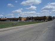
Caswell Hill is a district in the Canadian city of Saskatoon. It derives its name from an early homesteader Robert Caswell one of the Temperance Colonists of 1883. It is an area of beautiful character homes first built c 1905, tiny war-time houses, and newer houses. Caswell is a thriving and diverse community nestled between two economic areas, the downtown core, and the stores lining 33rd Street West. According to MLS data, the average sale price of a home as of 2013 was $248,594.[2]
Layout
Streets are laid out east and west, avenues are laid out running north and south. Streets increment in number as travel heads northward. Avenues increment alphabetically as travel proceeds west. The whole of the Caswell Hill community is also laid out in a grid pattern.[3]
Historic sites
Saskatoon Railway Station (Canadian Pacific) is one of many Saskatoon buildings listed in the Canadian Register of Historic Places. It is a Château style station which was built in 1907. Its current address is 305 Idylwyld Drive North, Idylwyld Drive used to be called Avenue A.[4]


Education
- Ashworth Holmes School opened for classes in 1909. It was constructed on Ashworth Holmes Hill (Present day site of Mayfair Pool)
- Caswell School, public elementary school
- Bedford Road Collegiate, public secondary school


Shopping
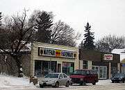

Small shops, cafes, and amenities line both sides of 33rd Street West.
Area parks
- Ashworth – Holmes Park (12.68 acres) derived its name from J. H. HOlmes and John Ashworth. This realtors of the early 1900s purchased most of the land now named the Caswell Hill Subdivision. (Their purchase was bordered by Idylwyld to Avenue H and 22nd to 29th Streets) They subdivided the land and sold it, but donated 10 acres (40,000 m2) to the City which became this park area.
Swimming facilities
- Mayfair Swimming Pool – 1025 Ave F North – pool with mini waterslide
Transportation
City transit
Caswell Hill is serviced by City Transit Bus Routes and since 1913, has housed the city's original streetcar building at Avenue C and 24th Street. The city transit headquarters afterwards adopted these buildings for bus warehouse garages and offices between Avenue C and D at 24th Street. A seven million CA$ consultant plan has been approved by the Saskatoon planning and operations committee to relocate the transit bus barns. The Caswell neighborhood will be revitalised by renovating the 13-acre (53,000 m2) area with a community for artists and musicians enhanced with a music festival.[5]
22nd Street (Highway 14) is a major thoroughfare through Saskatoon. Highway 7 has its junction at (Highway 14. Highway 14 connects with Asquith, Biggar Wilkie, Unity, and Macklin en route to Alberta.
Idylwyld Drive has had many titles: Avenue A, (Highway 11 and most currently Louis Riel Trail. It is a main thoroughfare through the city connecting Regina, Saskatoon and Prince Albert, Saskatchewan. It also connects west Saskatoon with the bedroom communities of Warman and Martensville
Life
Caswell Community Association provides leisure activities for various age groups and operates out of Caswell School[6]
References
- ↑ Neighborhood Profiles Caswell Hill URL accessed February 4, 2007
- ↑ "Caswell Hill". Saskatoon Realty. Retrieved 2013-10-26.
- ↑ Selling an Idea or a Product Archived September 29, 2007, at the Wayback Machine. URL accessed January 27, 2007
- ↑ Historic Places – The Register URL accessed February 24, 2007
- ↑ Beaudry, Morgan (March 19–25, 2010). "Caswell Hill Overhaul Approved". VerbNews.com. p. 2.
- ↑ [CaswellHill.ca] URL accessed February 2, 2007
External links
| Wikimedia Commons has media related to Caswell Hill. |
- Local Area Planning
- Willingdon Place
- City of Saskatoon Archives – A View From Above – HST-019-05 ...
- Narratives of Saskatoon Picture of Saskatoon in 1890
- City of Saskatoon City of Saskatoon · Departments · Community Services · City Planning · ZAM Maps
- Populace Spring 2006
 |
Mayfair | | ||
| Hudson Bay Park / Westmount | |
Central Industrial / Central Business District | ||
| ||||
| | ||||
| Riversdale |