Chicamocha Canyon
| Chicamocha Canyon | |
|---|---|
| Cañón del Chicamocha | |
|
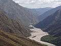
View of the Chicamocha River in the Chicamocha Canyon | |
 Chicamocha Canyon | |
| Floor elevation | approx. 2,600 feet (800 m) |
| Geography | |
| Coordinates | 6°45′N 73°02′W / 6.750°N 73.033°WCoordinates: 6°45′N 73°02′W / 6.750°N 73.033°W |

The Chicamocha Canyon (CHEE-kah-MOW-cha) is a steep sided canyon carved by the Chicamocha River. This river flows through the departments of Boyacá and Santander, where it reaches its maximum depth near the outskirts of Bucaramanga.
The canyon is the result of the erosion caused by water. It created deep cliffs on both sides. The Chicamocha Canyon begins near the town of Soatá in the Department of Boyacá and flows mainly through the Department of Santander, extending all the way to the municipality of Lebrija. This geographic feature was caused by the movement of tectonic plates that extend from the Chicamocha canyon to other regions such as Bucaramanga.
The canyon extends over 108,000 acres and 2000 meters in depth. The canyon was formed about 46 million years ago. On this territory many million years ago, there was a lake that hosted many marine animals whose remains have been found. The canyon is currently administered by Chicamocha National Park.
In 2009, the canyon was nominated as one of the 7 natural wonders contest.[1]
Etymology
The name Chicamocha in the Chibcha language of the Muisca means "silver-plated son, under the moon on the mountain range".[2]
Gallery
-

Fauna
-
-


See also
- Chicamocha National Park
- Department of Santander
- Geology of Colombia
- Tourism in Colombia
- List of canyons
References
- ↑ http://www.eltiempo.com/archivo/documento/CMS-5603329 Selection of Chicamocha Canyon
- ↑ (Spanish) Meaning of Chicamocha
Treasures of Colombia | |||||||||||||||||||||||||||||||||||||||||||||||||||||
|---|---|---|---|---|---|---|---|---|---|---|---|---|---|---|---|---|---|---|---|---|---|---|---|---|---|---|---|---|---|---|---|---|---|---|---|---|---|---|---|---|---|---|---|---|---|---|---|---|---|---|---|---|---|
Archaeological sites · Colombia magia salvaje · National monuments · National parks · World Heritage sites | |||||||||||||||||||||||||||||||||||||||||||||||||||||
| |||||||||||||||||||||||||||||||||||||||||||||||||||||
| |||||||||||||||||||||||||||||||||||||||||||||||||||||
| |||||||||||||||||||||||||||||||||||||||||||||||||||||
Source: Wills, Fernando et al. 2001. Nuestro patrimonio - 100 tesoros de Colombia - Our heritage - 100 treasures of Colombia, 1-311. El Tiempo. | |||||||||||||||||||||||||||||||||||||||||||||||||||||