El Peñón de Guatapé
| El Peñol de Guatapé | |
|---|---|
 Peñol de Guatapé | |
| Highest point | |
| Elevation | 2,135 m (7,005 ft) |
| Coordinates | 6°13′25″N 75°10′42″W / 6.22361°N 75.17833°WCoordinates: 6°13′25″N 75°10′42″W / 6.22361°N 75.17833°W |
| Geography | |
| Parent range | Andes |
| Geology | |
| Mountain type | Granite dome |
| Climbing | |
| First ascent | Prehistoric |
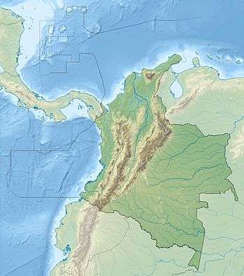

La Piedra Del Peñol (Spanish for "The Rock of Guatapé"),[1] also known as El Peñol Stone or simply La Piedra (Spanish for "The Stone"),[2] is a monolithic formation located at the town and municipality of Guatapé, 1 km inside the city limits (86 km northeast of Medellín or 2 hours by bus) in Antioquia, Colombia.
History
The Tahamies Indians, former inhabitants of this region, worshiped the rock and called it in their language "mojarrá" or "mujará" (rock or stone). This rock is located in the rural area called "La Piedra", just 5 minutes from the town of Guatapé, and can be reached by road.
On the northern face of the stone there are painted large white letters "G" and an incomplete "U" (only the single vertical stroke was completed). Guatapé and El Peñol had long disputed ownership of the rock, and the residents of Guatapé decided to settle the matter by painting the town's name on the rock in huge white letters. It did not take long for the residents of El Peñol to notice the work, and a large mob was assembled to stop it. Only the "G" and part of the "U" were completed.
The rock was first climbed officially on July 1954. In 2006, Luis Villegas, Pedro Nel Ramirez, and Ramón Díaz climbed the rock in a five-day endeavor, using sticks that were fixed against the rock's wall.[3]
A new species of plant was found on the top of the rock, subsequently named Pitcairnia heterophylla by a German scientist.
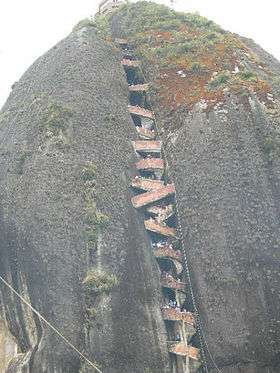
A viewing spot was built on top of the rock, where it is possible to acquire handicrafts, postcards, and other local goods. It is possible to see the 500 km shore-perimeter dam. There are 740 steps to the uppermost step atop the building at the summit, a fact reinforced by yellow numbers also seen in the climb up the stairs.
In the 1940s, the Colombian government declared it a "National Monument".[4]
Composition
The stone rises from the bottom of the hydroelectric dam of Peñol-Guatapé. This monolith was spotted as a border landmark between country farms and the two cities.
At its highest part, on the rear (southeast side), it has an elevation of 2,135 metres (7,005 ft) over sea level. with an average temperature of 18 °C (64 °F). The "Peñol" has 22 cubic megametres (7.8×10²⁰ cu ft) of rock mass and it is 385 metres (1,263 ft) long, with an approximate weight of 66 million tonnes (65,000,000 long tons; 73,000,000 short tons). It has some rock breaks, one of which was used for the construction of the 650 stairs[5] that can be used to go to the top.
The Stone of Peñol is composed of quartz, feldspar and mica.
References
- ↑ Official Guatapé Site http://www.guatape-antioquia.gov.co
- ↑ Jens Porup; Kevin Raub; Robert Reid (6 June 2009). Colombia 5. Lonely Planet. p. 216. ISBN 978-1-74104-827-8. Retrieved 18 December 2012.
- ↑ Author, Alvaro Idarraga (2006). "El Zócalo", Guatapé: Museo Histórico de Guatapé.
- ↑ Guatapé's Major Office
- ↑ La Guía Verde Colombia: Actualizada Práctica Completa Para todos los viajeros. MICHELIN. 1 January 2011. p. 258. ISBN 978-2-06-716548-9. Retrieved 18 December 2012.
See also
External links
Capital: Medellín | |||||||||||||||||||||||||||||||||||
| Regions and municipalities |
| ||||||||||||||||||||||||||||||||||
| Related topics | |||||||||||||||||||||||||||||||||||
Treasures of Colombia | |||||||||||||||||||||||||||||||||||||||||||||||||||||
|---|---|---|---|---|---|---|---|---|---|---|---|---|---|---|---|---|---|---|---|---|---|---|---|---|---|---|---|---|---|---|---|---|---|---|---|---|---|---|---|---|---|---|---|---|---|---|---|---|---|---|---|---|---|
Archaeological sites · Colombia magia salvaje · National monuments · National parks · World Heritage sites | |||||||||||||||||||||||||||||||||||||||||||||||||||||
| |||||||||||||||||||||||||||||||||||||||||||||||||||||
| |||||||||||||||||||||||||||||||||||||||||||||||||||||
| |||||||||||||||||||||||||||||||||||||||||||||||||||||
Source: Wills, Fernando et al. 2001. Nuestro patrimonio - 100 tesoros de Colombia - Our heritage - 100 treasures of Colombia, 1-311. El Tiempo. | |||||||||||||||||||||||||||||||||||||||||||||||||||||