Chełmno
| Chełmno | |||
|---|---|---|---|
|
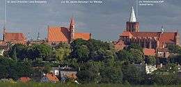
Church of St. James and St. Nicholas - a medieval gothic church in Chełmno. | |||
| |||
 Chełmno | |||
| Coordinates: 53°20′57″N 18°25′23″E / 53.34917°N 18.42306°E | |||
| Country |
| ||
| Voivodeship | Kuyavian-Pomeranian | ||
| County | Chełmno County | ||
| Gmina | Chełmno (urban gmina) | ||
| Area | |||
| • Total | 13.56 km2 (5.24 sq mi) | ||
| Elevation | 75 m (246 ft) | ||
| Population (2006) | |||
| • Total | 20,388 | ||
| • Density | 1,500/km2 (3,900/sq mi) | ||
| Postal code | 86-200 | ||
| Website | http://www.chelmno.pl/ | ||

Chełmno [ˈxɛu̯mnɔ] (older English: Culm; German: ![]() Kulm ) is a town in northern Poland near the Vistula river with 20,000 inhabitants and the historical capital of Chełmno Land. Situated in the Kuyavian-Pomeranian Voivodeship since 1999, Chełmno was previously in Toruń Voivodeship (1975–1998).
Kulm ) is a town in northern Poland near the Vistula river with 20,000 inhabitants and the historical capital of Chełmno Land. Situated in the Kuyavian-Pomeranian Voivodeship since 1999, Chełmno was previously in Toruń Voivodeship (1975–1998).
Name
The city's name Chełmno comes from the old Polish word for hill: "chelm".[1][2] After the arrival of the Teutonic Knights, the city was founded in 1232 using the Latin name Colmen. During the Middle Ages, the German name Culm was used in official documents regarding the town, as the city was a member of the Hanseatic League and part of the State of the Teutonic Order.[3] Chełmno came under Prussian jurisdiction in 1772 and the German name Culm became again official. It was officially renamed Kulm in 1872. During the Nazi occupation in World War II, the town was again renamed from Chełmno to Kulm.
History
The first written mention of Chełmno is known from a document allegedly issued in 1065 by Duke Boleslaus of Poland for the Benedictine monastery in Mogilno. In 1226 Duke Konrad I of Masovia invited the Teutonic Knights to Chełmno Land. In 1233 Kulm was granted city rights known as "Kulm law" (renewed in 1251), the model system for over 200 Polish towns. The town grew prosperous as a member of the mercantile Hanseatic League. Kulm and Chelmno Land were part of the Teutonic Knights' state until 1466, when after the Thirteen Years' War Chełmno was incorporated into Poland and made the capital of Chełmno Voivodeship.
In 1772, following the First Partition of Poland-Lithuania, the city was taken over by the Kingdom of Prussia. Between 1807 and 1815 Chełmno was part of the Duchy of Warsaw, being reannexed by Prussia at the end of the Napoleonic Wars.
Kulm had been a garrison town. In 1776 Frederic the Great founded here a cadet school which was to serve in Germanising Polish areas and nobility[4] In 1890 the garrison included 561 military staff.[5] On 1 October 1890 the cadet school was moved to Köslin in Farther Pomerania.[6]
Chełmno was given to Poland in 1920 following World War I.
When World War II broke out in 1939, Nazi German authorities murdered 5,000 Polish civilians upon taking control of the territory.[7] The atrocities took place in Klamry, Małe Czyste, Podwiesk, Plutowo, Dąbrowa Chełmińska, and Wielkie Łunawy, while many other Poles were executed in forests.[7] The rest of the Polish population was expelled to the General Government in line with the German policy of Lebensraum. Polish Secret State resistance groups such as Polska Żyje ("Poland Lives"), Rota, Grunwald, and Szare Szeregi were also active in the area. The area was administered as part of Reichsgau Danzig-West Prussia and served as the seat of the district/county (kreis) of Kulm.
On 25 January 1945 German forces set fire to several buildings in the city, including a hospital, a railway terminal, and a brewery, while retreating (see scorched earth).
Demographics
Since its founding, the city had a mixed population of Germans and Poles, with the latter making ⅔ of its population in the second half of the 19th century.[8]
| Year | Inhabitants | Notes |
|---|---|---|
| 1843 | 5,000[9] | |
| 1890 | 9,762 | incl. 3,450 Protestants and 470 Jews.[5] |
| 1900 | 11,079 | together with the garrison, incl. 3,530 Protestants and 339 Jews.[6] |
| 1921 | 11,700 | incl. 1,060 Germans.[10] |
| 1969 | 18,000 [11] | |
| 2006 | 20,388 | |
Main sights
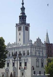
Chełmno has a well-preserved medieval center, with five Gothic churches and a beautiful Renaissance town hall in the middle of the market square.
The Old Town is one of Poland's official national Historic Monuments (Pomnik historii), as designated April 20, 2005, and tracked by the National Heritage Board of Poland.
- Gothic churches:
- Church of St Mary, former main parochial church of town, built 1280-1320 (with St. Valentine relic)
- Church of Saints Jacob and Nicholas, former Franciscan church, from the 14th century, rebuilt in the 19th century
- Church of Saints Peter and Paul, former Dominican church, from the 13th and 14th centuries, rebuilt in the 18th and 19th centuries
- Church of Saints John the Baptist and Johns the Evangelist, former Benedictine and Cistercian nuns' church, with monastery, built 1290-1330
- Church of Holy Ghost, from 1280–90
- Town hall, whose oldest part comes from the end of the 13th century, rebuilt in manneristic style (under Italian influence) in 1567-1572
- City walls which surround whole city, preserved almost as a whole, with watch towers and Grudziądzka Gate
Chełmno gives its name to the protected area called Chełmno Landscape Park, which stretches along the right bank of the Vistula.
Notable residents
- Friedrich-Carl Cranz (1886–1941), general
- Hans Dominik (1870–1910), colonial officer
- Roderich von Erckert (1821-1900), ethnographer
- Friedrich Fülleborn (1866–1933), physician and tropical disease specialist
- Grzegorz Gerwazy Gorczycki (1665–1734), composer and priest
- Heinz Guderian (1888–1954), blitzkrieg and tank theorist
- Hermann Löns (1866–1914), writer
- Ernst Wilhelm Lotz (1890–1914), writer
- Michael Otto (born 1943), entrepreneur
- Franciszek Raszeja (1896–1942), doctor
- Leon Raszeja (1901–1939), lawyer
- Maksymilian Raszeja (1889–1939), theologian
- Albrecht von Roon (1803-1879), Prussian soldier and politician, Prime Minister of Prussia
- Ludwik Rydygier (1850–1920), doctor
- Georg Salzberger (1882–1975), Jewish rabbi
- Walter Schilling (1895–1943), Wehrmacht general
- Kurt Schumacher (1895–1952), politician
- Max Sperling (1905–1984), Wehrmacht officer
- Max Stirner (1806–1856), philosopher
- Wojciech Stanisław Leski (1702–1758), Bishop of Chelmno
References
- ↑ Acta Universitatis Nicolai Copernici: Nauki humanistyczo-społeczne, Issues 22-28 Uniwersytet Mikołaja Kopernika, 1967, page 6
- ↑ Słownik etymologiczny nazw geograficznych Polski Maria Malec Wydawn. Naukowe PWN, 2002, page 56
- ↑ Heinrich Gottfried Philipp Gengler: Regesten und Urkunden zur Verfassungs- und Rechtsgeschichte der deutschen Städte im Mittelalter, Erlangen 1863, pp. 679-680.
- ↑ Polacy i Niemcy wobec siebie Stanisław Salmonowicz, Ośrodek Badań Naukowych im. W. Kętrzyńskiego, 1993
- 1 2 Brockhaus Konversations-Lexikon. 14th edition, vol. 4, Berlin and Vienna 1892, p. 624-625 (in German).
- 1 2 Meyers Konversations-Lexikon. 6th edition, vol. 11, Leipzig and Vienna 1908, p. 785-786 (in German).
- 1 2 Institute of National Remembrance data, based on Leszczynski, Kazimierz "Eksterminacja ludności w Polsce w czasie okupacji niemieckiej 1939-1945", Warsaw, 1962
- ↑ Blitzkrieg w Polsce wrzesien 1939 Richard Hargreaves, page 29, Bellona Warsaw 2009
- ↑ Universal-Lexikon der Gegenwart und Vergangenheit (H. A. Pierer, ed.). 2nd edition, vol. 17, Altenburg 1843, p. 51 (in German).
- ↑ Der Große Brockhaus. 15th edition, vol. 4, Leipzig 1929, p. 297-298 (in German).
- ↑ Meyers Enzyklopädisches Lexikon. 9th edition, vol. 6, Mannheim/Vienna/Zürich 1972, p. 122 (in German).
| Wikimedia Commons has media related to Chełmno. |
Coordinates: 53°20′57″N 18°25′23″E / 53.34917°N 18.42306°E
| Seat |
|  |
|---|---|---|
| Rural gminas | ||
External links
- "Shoah (Film) Interview with Gustav Laabs" - Interview