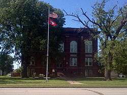
Charleston, Arkansas
| Charleston, Arkansas | |
|---|---|
| City | |
|
| |
 Location in Franklin County and the state of Arkansas | |
| Coordinates: 35°17′55″N 94°2′27″W / 35.29861°N 94.04083°WCoordinates: 35°17′55″N 94°2′27″W / 35.29861°N 94.04083°W | |
| Country | United States |
| State | Arkansas |
| County | Franklin |
| Area | |
| • Total | 4.4 sq mi (11.4 km2) |
| • Land | 4.3 sq mi (11.1 km2) |
| • Water | 0.1 sq mi (0.3 km2) |
| Elevation | 518 ft (158 m) |
| Population (2010) | |
| • Total | 2,522 |
| • Density | 590/sq mi (227.7/km2) |
| Time zone | Central (CST) (UTC-6) |
| • Summer (DST) | CDT (UTC-5) |
| ZIP code | 72933 |
| Area code(s) | 479 |
| FIPS code | 05-13300 |
| GNIS feature ID | 0076590 |
Charleston is a city in Franklin County, Arkansas, United States, and (along with Ozark) one of the two county seats of Franklin County.[1] It is part of the Fort Smith, Arkansas-Oklahoma Metropolitan Statistical Area. The population was 2,522 at the 2010 census,[2] down from 2,965 at the 2000 census.
Geography
Charleston is in southwestern Franklin County, along Arkansas Highway 22, which leads east 9 miles (14 km) to Ratcliff and west 24 miles (39 km) to Fort Smith.
According to the United States Census Bureau, Charleston has a total area of 4.4 square miles (11.4 km2), of which 4.3 square miles (11.1 km2) is land and 0.1 square miles (0.3 km2), or 2.53%, is water.[2]
Demographics
| Historical population | |||
|---|---|---|---|
| Census | Pop. | %± | |
| 1880 | 393 | — | |
| 1890 | 370 | −5.9% | |
| 1910 | 576 | — | |
| 1920 | 734 | 27.4% | |
| 1930 | 851 | 15.9% | |
| 1940 | 958 | 12.6% | |
| 1950 | 968 | 1.0% | |
| 1960 | 1,036 | 7.0% | |
| 1970 | 1,497 | 44.5% | |
| 1980 | 1,748 | 16.8% | |
| 1990 | 2,128 | 21.7% | |
| 2000 | 2,965 | 39.3% | |
| 2010 | 2,522 | −14.9% | |
| Est. 2015 | 2,483 | [3] | −1.5% |
2014 Estimate[5] | |||
As of the census[6] of 2000, there were 2,965 people, 1,201 households, and 815 families residing in the city. The population density was 706.4 people per square mile (272.6/km²). There were 1,315 housing units at an average density of 313.3 per square mile (120.9/km²). The racial makeup of the city was 95.58% White, 0.07% Black or African American, 0.64% Native American, 0.34% Asian, 1.48% from other races, and 1.89% from two or more races. 2.06% of the population were Hispanic or Latino of any race.
There were 1,201 households out of which 31.7% had children under the age of 18 living with them, 52.3% were married couples living together, 11.9% had a female householder with no husband present, and 32.1% were non-families. 29.2% of all households were made up of individuals and 14.7% had someone living alone who was 65 years of age or older. The average household size was 2.40 and the average family size was 2.96.
In the city the population was spread out with 25.7% under the age of 18, 7.9% from 18 to 24, 26.7% from 25 to 44, 20.4% from 45 to 64, and 19.3% who were 65 years of age or older. The median age was 38 years. For every 100 females there were 92.3 males. For every 100 females age 18 and over, there were 89.7 males.
The median income for a household in the city was $30,824, and the median income for a family was $39,598. Males had a median income of $27,917 versus $18,512 for females. The per capita income for the city was $14,912. About 8.6% of families and 14.4% of the population were below the poverty line, including 17.1% of those under age 18 and 16.6% of those age 65 or over.
Notable natives
- Dale Bumpers, governor of Arkansas and U.S. senator from Arkansas
- Eddy Carmona, American football punter and placekicker for the Oakland Raiders
- Steve Cox, former American football punter and placekicker and Super Bowl winner with the Washington Redskins in Super Bowl XXII
Education
Public education
The Charleston School District provides public education from kindergarten through grade 12 from its three facilities, Charleston High School (grades 9–12), Charleston Elementary School (grades K–4), and Charleston Middle School (grades 5–8).
The Public School District of Charleston, Arkansas was the first school district to integrate in the former Confederate States of America. The high school was destroyed in middle 2010 to make way for a larger middle school. There is currently a small monument to the integration in front of Charleston Middle School.
References
- ↑ "Find a County". National Association of Counties. Archived from the original on 2011-05-31. Retrieved 2011-06-07.
- 1 2 "Geographic Identifiers: 2010 Census Summary File 1 (G001): Charleston city, Arkansas (revised 05-17-2012)". American Factfinder. U.S. Census Bureau. Retrieved April 19, 2016.
- ↑ "Annual Estimates of the Resident Population for Incorporated Places: April 1, 2010 to July 1, 2015". Retrieved July 2, 2016.
- ↑ "Census of Population and Housing". Census.gov. Archived from the original on May 11, 2015. Retrieved June 4, 2015.
- ↑ "Annual Estimates of the Resident Population for Incorporated Places: April 1, 2010 to July 1, 2014". Retrieved June 4, 2015.
- ↑ "American FactFinder". United States Census Bureau. Archived from the original on 2013-09-11. Retrieved 2008-01-31.
Municipalities and communities of Franklin County, Arkansas, United States | ||
|---|---|---|
| Cities | 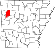 | |
| Town | ||
| Unincorporated communities | ||
| Ghost town | ||