Chandrapur district
| Chandrapur district चंद्रपूर जिल्हा | |
|---|---|
| District of Maharashtra | |
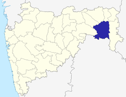 Location of Chandrapur district in Maharashtra | |
| Country | India |
| State | Maharashtra |
| Administrative division | Nagpur Division |
| Headquarters | Chandrapur |
| Tehsils | 1. Chandrapur, 2. Bhadravati, 3. Warora, 4. Chimur, 5. Nagbhid, 6. Bramhapuri, 7. Sindewahi, 8. Mul, 9. Saoli, 10. Gondpimpri, 11. Rajura, 12. Korpana, 13. Pomburna, 14. Ballarpur, 15. Jivati |
| Government | |
| • Lok Sabha constituencies | 1. Chandrapur (shared with Yavatmal district), 2. Gadchiroli-Chimur (shared with Gadchiroli district) |
| • Assembly seats | 6 |
| Area | |
| • Total | 10,690 km2 (4,130 sq mi) |
| Population (2001) | |
| • Total | 2,071,101 |
| • Density | 190/km2 (500/sq mi) |
| • Urban | 32.11% |
| Demographics | |
| • Literacy | 59.41% |
| Average annual precipitation | 1398 mm |
| Website | Official website |
Chandrapur District is a district in Nagpur Division of the Indian state of Maharashtra. The district was formerly known as Chanda District. In 1964, it was renamed as Chandrapur. It was the largest district in India until it was split into the separate district of Gadchiroli. It had a population of 2,071,101 of which 32.11% were urban as of 2001.[1]
It is famous for its Super Thermal Power Plant, one of the biggest in Asia, and its vast reserves of coal in Wardha Valley Coalfield. Chandrapur also has large reservoirs of limestone. The abundance of lime and coal supplies many cement factories like L&T (now UltraTech Cement), Gujarat Ambuja (Maratha Cement Works), Manikgarh, Murli Cement and ACC Cement in the district.
Tadoba National Park near Chandrapur is one of India's 28 Project tiger reserves.
The city of Chandrapur, the administrative headquarters, has ancient temples of Anchaleshwar (Lord Shiva) and Mahakali (Goddess Mahakali).
Divisions
Chandrapur district comprises 15 talukas, namely Chandrapur, Ballarpur, Rajura, Bhadravati, Warora, Chimur, Nagbhid, Bramhapuri, Sindewahi, Mul, Sawali, Gondpipri, Korpana, Pombhurna and Jiwati.
The district has six Vidhan Sabha (legislative assembly) constituencies: Rajura, Chandrapur, Ballarpur, Warora, Brahmapuri and Chimur. Rajura, Chandrapur, Ballarpur and Warora are part of Chandrapur Lok Sabha constituency. Brahmapuri and Chimur are part of Gadchiroli-Chimur Lok Sabha constituency.[2]
Demography
According to the 2011 census Chandrapur district had a population of 2,194,262,[3] roughly equal to the nation of Latvia[4] or the US state of New Mexico.[5] This gives it a ranking of 207th in India (out of a total of 640).[3] The district has a population density of 192 inhabitants per square kilometre (500/sq mi) .[3] Its population growth rate over the decade 2001–2011 was 5.95%.[3] Chandrapur has a sex ratio of 959 females for every 1000 males,[3] and a literacy rate of 81.35%.[3]
Geography
Chandrapur district is located in the eastern edge of Maharashtra in Nagpur division and forms the eastern part of 'Vidarbha' region. It is located between 19.30’ N and 20.45’ N latitude and 78.46’E longitude.
Economy
In 2006 the Ministry of Panchayati Raj named Chandrapur one of the country's 250 most backward districts (out of a total of 640).[6] It is one of the twelve districts in Maharashtra currently receiving funds from the Backward Regions Grant Fund Programme (BRGF).[6]
References
- ↑ "Archived copy". Archived from the original on 27 July 2007. Retrieved 2009-08-27.
- ↑ "District wise List of Assembly and Parliamentary Constituencies". Chief Electoral Officer, Maharashtra website. Archived from the original on 18 March 2010. Retrieved 5 September 2010.
- 1 2 3 4 5 6 "District Census 2011". Census2011.co.in. 2011. Retrieved 2011-09-30.
- ↑ US Directorate of Intelligence. "Country Comparison:Population". Retrieved 2011-10-01.
Latvia 2,204,708 July 2011 est.
- ↑ "2010 Resident Population Data". U.S. Census Bureau. Archived from the original on 19 October 2013. Retrieved 2011-09-30.
New Mexico – 2,059,179
- 1 2 Ministry of Panchayati Raj (8 September 2009). "A Note on the Backward Regions Grant Fund Programme" (PDF). National Institute of Rural Development. Archived from the original (PDF) on 5 April 2012. Retrieved 27 September 2011.
External links

| Topics | |||||||||||||||||||||||
|---|---|---|---|---|---|---|---|---|---|---|---|---|---|---|---|---|---|---|---|---|---|---|---|
| Regions | |||||||||||||||||||||||
| Divisions and Districts |
| ||||||||||||||||||||||
| Million-plus cities in Maharashtra | |||||||||||||||||||||||
| Other cities with municipal corporations | |||||||||||||||||||||||
Portal: Maharashtra | |||||||||||||||||||||||
| Rivers |
|    | |||||||||||||||||||||||||
|---|---|---|---|---|---|---|---|---|---|---|---|---|---|---|---|---|---|---|---|---|---|---|---|---|---|---|---|
| Dams, barrages | |||||||||||||||||||||||||||
| Geographical features / regions | |||||||||||||||||||||||||||
| Riparian districts |
| ||||||||||||||||||||||||||
| Cities | |||||||||||||||||||||||||||
| Languages / people | |||||||||||||||||||||||||||
| Coalfields | |||||||||||||||||||||||||||
| Oil / gas fields | |||||||||||||||||||||||||||
| Industries |
| ||||||||||||||||||||||||||
| Transport | |||||||||||||||||||||||||||
| Related topics | |||||||||||||||||||||||||||
| Other basins | |||||||||||||||||||||||||||
Coordinates: 19°57′N 79°18′E / 19.950°N 79.300°E