Chūō, Yamanashi
| Chūō 中央市 | |||
|---|---|---|---|
| City | |||
|
Koikawa Post Office in Chūō, Yamanashi | |||
| |||
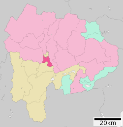 Location of Chūō in Yamanashi Prefecture | |||
 Chūō
| |||
| Coordinates: 35°35′58.6″N 138°38′2.1″E / 35.599611°N 138.633917°ECoordinates: 35°35′58.6″N 138°38′2.1″E / 35.599611°N 138.633917°E | |||
| Country | Japan | ||
| Region | Chūbu | ||
| Prefecture | Yamanashi Prefecture | ||
| Area | |||
| • Total | 31.69 km2 (12.24 sq mi) | ||
| Population (November 1, 2012) | |||
| • Total | 30,499 | ||
| • Density | 962/km2 (2,490/sq mi) | ||
| Time zone | Japan Standard Time (UTC+9) | ||
| Phone number | 055-274-1111 | ||
| Address | Usuiahara 301-1, Chūō City, Yamanashi 409-3892 | ||
| Website |
www | ||


Chūō (中央市 Chūō-shi) is a city located in central Yamanashi Prefecture, Japan.
As of November 2015, the city had an estimated population of 30,499 and a population density of 962 persons per km². The total area was 31.69 square kilometres (12.24 sq mi).
Geography
Chūō is located near the geographic center of the Kōfu Plateau of central Yamanashi Prefecture, hence its name which means centre in Japanese. the Fuefuki River flows through the city.
Surrounding municipalities
Yamanashi Prefecture
History
The modern city of Chūō was established on February 20, 2006, from the merger of the towns of Tamaho and Tatomi (both from Nakakoma District), and the village of Toyotomi (from Higashiyatsushiro District).
Economy
The economy of Chūō is dominated by agriculture, with rice, corn and tomatoes as the major cash crops.
Education
- University of Yamanashi – Medical School campus
- Chūō has six elementary schools and three middle schools, but no high school.
Transportation
Railway
Highway
External links
![]() Media related to Chūō, Yamanashi at Wikimedia Commons
Media related to Chūō, Yamanashi at Wikimedia Commons
- Official website (Japanese)
- Central Japan Railway's information about the Chūō Shinkansen
- Linear Chūō Express (Japanese)
| Special city | ||
|---|---|---|
| Cities | ||
| Kitatsuru District | ||
| Minamikoma District | ||
| Minamitsuru District | ||
| Nakakoma District | ||
| Nishiyatsushiro District | ||