Cedar Springs, Georgia
| Cedar Springs, Georgia | |
|---|---|
| Census-designated place | |
 Cedar Springs | |
| Coordinates: 31°11′01″N 85°02′17″W / 31.18361°N 85.03806°WCoordinates: 31°11′01″N 85°02′17″W / 31.18361°N 85.03806°W | |
| Country | United States |
| State | Georgia |
| County | Early |
| Area[1] | |
| • Total | 2.978 sq mi (7.71 km2) |
| • Land | 2.978 sq mi (7.71 km2) |
| • Water | 0 sq mi (0 km2) |
| Elevation | 151 ft (46 m) |
| Population (2010) | |
| • Total | 74 |
| • Density | 25/sq mi (9.6/km2) |
| Time zone | Eastern (EST) (UTC-5) |
| • Summer (DST) | EDT (UTC-4) |
| ZIP code | 39832 |
| Area code(s) | 229 |
| GNIS feature ID | 312495[2] |
Cedar Springs is a census-designated place and unincorporated community in Early County, Georgia, United States. Its population was 74 as of the 2010 census.[1] Cedar Springs has a post office with ZIP code 31629.[3] Georgia State Route 273 passes through the community.
References
- 1 2 "2010 Census Gazetteer Files - Places: Georgia". U.S. Census Bureau. Retrieved January 2, 2015.
- ↑ "Cedar Springs". Geographic Names Information System. United States Geological Survey.
- ↑ United States Postal Service. "USPS - Look Up a ZIP Code". Retrieved January 2, 2015.
Municipalities and communities of Early County, Georgia, United States | ||
|---|---|---|
| Cities | 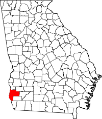 | |
| CDP | ||
| Unincorporated community | ||
| Footnotes | ‡This populated place also has portions in an adjacent county or counties | |
This article is issued from Wikipedia - version of the 5/20/2016. The text is available under the Creative Commons Attribution/Share Alike but additional terms may apply for the media files.