Early County, Georgia
| Early County, Georgia | |
|---|---|
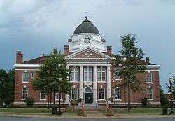 Early County Courthouse in Blakely | |
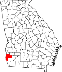 Location in the U.S. state of Georgia | |
 Georgia's location in the U.S. | |
| Founded | 1818 |
| Named for | Peter Early |
| Seat | Blakely |
| Largest city | Blakely |
| Area | |
| • Total | 516 sq mi (1,336 km2) |
| • Land | 513 sq mi (1,329 km2) |
| • Water | 3.8 sq mi (10 km2), 0.7% |
| Population | |
| • (2010) | 11,008 |
| • Density | 21/sq mi (8/km²) |
| Congressional district | 2nd |
| Time zone | Eastern: UTC-5/-4 |
| Website |
earlycounty |
Early County is a county located in the southwest of the U.S. state of Georgia. As of the 2010 census, the population was 11,008.[1] The county seat is Blakely, home of the Early County Courthouse.[2] Created by European Americans on December 15, 1818, it was named for Peter Early.[3] The county is bordered on the west by the Chattahoochee River.
History
Prehistoric and nineteenth-century history has been preserved in some of Early County's attractions. It is the site of the Kolomoki Mounds, a park preserving major earthworks built by indigenous peoples of the Woodland culture more than 1700 years ago, from 350 CE to 600 CE. This is one of the largest mound complexes in the United States and the largest in Georgia; it includes burial and ceremonial mounds. The siting of the mounds expresses the ancient people's cosmology, as mounds are aligned with the sun at the spring equinox and summer solstice.
The county area was territory of the historic Creek Indian peoples of the Southeast, particularly along the Chattahoochee River, before European-American settlers encroached and pushed them out during Indian Removal of the first half of the nineteenth century.
The Cohelee Creek Bridge in the county is the southernmost covered bridge still standing. One of the last wooden flagpoles from the American Civil War era is located at the historic courthouse in downtown Blakely.
Geography
According to the U.S. Census Bureau, the county has a total area of 516 square miles (1,340 km2), of which 513 square miles (1,330 km2) is land and 3.8 square miles (9.8 km2) (0.7%) is water.[4]
The northeastern and eastern portions of Early County, east of Blakely, and extending south to a line east of Jakin, are located in the Spring Creek sub-basin of the ACF River Basin (Apalachicola-Chattahoochee-Flint River Basin). The western portion of the county is located in the Lower Chattahoochee River sub-basin of the same ACF River Basin.[5]
Major highways
Adjacent counties
- Clay County (north)
- Calhoun County (northeast)
- Baker County (east)
- Miller County (southeast)
- Seminole County (south or east)
- Houston County, Alabama (southwest/CST Border)
- Henry County, Alabama (west/CST Border)
Demographics
| Historical population | |||
|---|---|---|---|
| Census | Pop. | %± | |
| 1820 | 768 | — | |
| 1830 | 2,051 | 167.1% | |
| 1840 | 5,444 | 165.4% | |
| 1850 | 7,246 | 33.1% | |
| 1860 | 6,149 | −15.1% | |
| 1870 | 6,998 | 13.8% | |
| 1880 | 7,611 | 8.8% | |
| 1890 | 9,792 | 28.7% | |
| 1900 | 14,828 | 51.4% | |
| 1910 | 18,122 | 22.2% | |
| 1920 | 18,983 | 4.8% | |
| 1930 | 18,273 | −3.7% | |
| 1940 | 18,679 | 2.2% | |
| 1950 | 17,413 | −6.8% | |
| 1960 | 13,151 | −24.5% | |
| 1970 | 12,682 | −3.6% | |
| 1980 | 13,158 | 3.8% | |
| 1990 | 11,854 | −9.9% | |
| 2000 | 12,354 | 4.2% | |
| 2010 | 11,008 | −10.9% | |
| Est. 2015 | 10,575 | [6] | −3.9% |
| U.S. Decennial Census[7] 1790-1960[8] 1900-1990[9] 1990-2000[10] 2010-2013[1] | |||
2000 census
As of the census[11] of 2000, there were 12,354 people, 4,695 households, and 3,295 families residing in the county. The population density was 24 people per square mile (9/km²). There were 5,338 housing units at an average density of 10 per square mile (4/km²). The racial makeup of the county was 50.3% White, 48.1% Black or African American, 0.2% Native American, 0.2% Asian, 0.1% Pacific Islander, 0.4% from other races, and 0.8% from two or more races. 1.2% of the population were Hispanic or Latino of any race.
There were 4,695 households out of which 32.00% had children under the age of 18 living with them, 45.00% were married couples living together, 20.80% had a female householder with no husband present, and 29.80% were non-families. 26.90% of all households were made up of individuals and 12.70% had someone living alone who was 65 years of age or older. The average household size was 2.58 and the average family size was 3.13.
In the county the population was spread out with 28.70% under the age of 18, 7.80% from 18 to 24, 25.90% from 25 to 44, 21.90% from 45 to 64, and 15.70% who were 65 years of age or older. The median age was 36 years. For every 100 females there were 87.10 males. For every 100 females age 18 and over, there were 80.60 males.
The median income for a household in the county was $25,629, and the median income for a family was $31,215. Males had a median income of $36,458 versus $27,277 for females. The mean income for the county was $147,364. The per capita income for the county was $14,936. About 22.20% of families and 25.70% of the population were below the poverty line, including 37.20% of those under age 18 and 20.10% of those age 65 or over.
2010 census
As of the 2010 United States Census, there were 11,008 people, 4,228 households, and 2,924 families residing in the county.[12] The population density was 21.5 inhabitants per square mile (8.3/km2). There were 4,975 housing units at an average density of 9.7 per square mile (3.7/km2).[13] The racial makeup of the county was 49.6% black or African American, 48.4% white, 0.4% American Indian, 0.3% Asian, 0.5% from other races, and 0.8% from two or more races. Those of Hispanic or Latino origin made up 1.6% of the population.[12] In terms of ancestry, 8.2% were American, 6.1% were Irish, and 5.5% were German.[14]
Of the 4,228 households, 34.9% had children under the age of 18 living with them, 42.5% were married couples living together, 21.3% had a female householder with no husband present, 30.8% were non-families, and 27.3% of all households were made up of individuals. The average household size was 2.56 and the average family size was 3.12. The median age was 39.3 years.[12]
The median income for a household in the county was $26,928 and the median income for a family was $40,238. Males had a median income of $36,250 versus $28,401 for females. The per capita income for the county was $16,330. About 22.9% of families and 28.9% of the population were below the poverty line, including 46.4% of those under age 18 and 15.2% of those age 65 or over.[15]
Education
Communities
- Arlington (shared with Calhoun County)
- Blakely
- Damascus
- Jakin
- Georgia Pacific Cedar Springs Operations
Unincorporated communities
- Bancroft
- Cedar Springs
- Cederville
- Colomokee
- Crossroads
- Cuba
- Douglass Crossroads
- Douglasville
- Ferrell Crossroads
- Freeman
- Hentown
- Hilton
- Howards Mill
- Jones Crossroads
- Killarney
- Liberty
- Lucile
- Luke
- McLendon
- New Hope
- Nicholasville
- Pleasant Hill
- Rock Hill
- Rowena
- Saffold
- Sowhatchee
- Springfield
- Urquhart
See also
References
- 1 2 "State & County QuickFacts". United States Census Bureau. Retrieved June 22, 2014.
- ↑ "Find a County". National Association of Counties. Retrieved 2011-06-07.
- ↑
- ↑ "US Gazetteer files: 2010, 2000, and 1990". United States Census Bureau. 2011-02-12. Retrieved 2011-04-23.
- ↑ "Georgia Soil and Water Conservation Commission Interactive Mapping Experience". Georgia Soil and Water Conservation Commission. Retrieved 2015-11-24.
- ↑ "County Totals Dataset: Population, Population Change and Estimated Components of Population Change: April 1, 2010 to July 1, 2015". Retrieved July 2, 2016.
- ↑ "U.S. Decennial Census". United States Census Bureau. Retrieved June 22, 2014.
- ↑ "Historical Census Browser". University of Virginia Library. Retrieved June 22, 2014.
- ↑ "Population of Counties by Decennial Census: 1900 to 1990". United States Census Bureau. Retrieved June 22, 2014.
- ↑ "Census 2000 PHC-T-4. Ranking Tables for Counties: 1990 and 2000" (PDF). United States Census Bureau. Retrieved June 22, 2014.
- ↑ "American FactFinder". United States Census Bureau. Retrieved 2011-05-14.
- 1 2 3 "DP-1 Profile of General Population and Housing Characteristics: 2010 Demographic Profile Data". United States Census Bureau. Retrieved 2015-12-29.
- ↑ "Population, Housing Units, Area, and Density: 2010 - County". United States Census Bureau. Retrieved 2015-12-29.
- ↑ "DP02 SELECTED SOCIAL CHARACTERISTICS IN THE UNITED STATES – 2006-2010 American Community Survey 5-Year Estimates". United States Census Bureau. Retrieved 2015-12-29.
- ↑ "DP03 SELECTED ECONOMIC CHARACTERISTICS – 2006-2010 American Community Survey 5-Year Estimates". United States Census Bureau. Retrieved 2015-12-29.
External links
- Early County 2055 - a non-profit corporation established by native son Charles Barton Rice and Catherine B. Rice to support the revitalization, economic development and preservation of Blakely and Early County, Georgia.
- Blakely - Early County Chamber of Commerce - Chamber of Commerce for Blakely and surrounding communities of Jakin, Arlington and Damascus.
- Southwest Georgia Academy(SGA)-a private school is located in Damascus and its adjoining Counties by Georgia Independent School Association (GISA)
- Early County News, a local newspaper founded by the Fleming Family in 1859
- Early County historical marker
Further reading
- Jerald T. Milanich, The Archaeology of Precolumbian Florida (Gainesville: University Press of Florida, 1994).
- Jerald T. Milanich, et al., McKeithen Weeden Island: The Culture of Northern Florida, A.D. 200-900 (New York: Academic Press, 1984).
- Thomas J. Pluckhahn, Kolomoki: Settlement, Ceremony, and Status in the Deep South, A.D. 350 to 750 (Tuscaloosa: University of Alabama Press, 2003).
- William H. Sears, Excavations at Kolomoki: Final Report (Athens: University of Georgia Press, 1956).
- Christopher Trowell, "A Kolomoki Chronicle: The History of a Plantation, a State Park, and the Archaeological Search for Kolomoki's Prehistory," Early Georgia 26, no. 1 (1998).
- Mark Williams and Daniel T. Elliott, eds., A World Engraved: Archaeology of the Swift Creek Culture (Tuscaloosa: University of Alabama Press, 1998).
 |
Clay County | Calhoun County | | |
| Henry County, Alabama | |
Baker County | ||
| ||||
| | ||||
| Houston County, Alabama | Seminole County | Miller County |
Municipalities and communities of Early County, Georgia, United States | ||
|---|---|---|
| Cities | | |
| CDP | ||
| Unincorporated community | ||
| Footnotes | ‡This populated place also has portions in an adjacent county or counties | |
Coordinates: 31°20′N 84°55′W / 31.33°N 84.91°W