Carrickalinga
| Carrickalinga South Australia | |||||||||||||
|---|---|---|---|---|---|---|---|---|---|---|---|---|---|
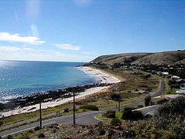 North Carrickalinga Beach | |||||||||||||
 Carrickalinga | |||||||||||||
| Coordinates | 35°26′0″S 138°19′0″E / 35.43333°S 138.31667°ECoordinates: 35°26′0″S 138°19′0″E / 35.43333°S 138.31667°E | ||||||||||||
| Population | 281 (2011 census)[1] | ||||||||||||
| Established | 1958[2] | ||||||||||||
| Postcode(s) | 5204[3] | ||||||||||||
| Location | 61 km (38 mi) South of Adelaide | ||||||||||||
| LGA(s) | District Council of Yankalilla | ||||||||||||
| State electorate(s) | Finniss[4] | ||||||||||||
| Federal Division(s) | Mayo[5] | ||||||||||||
| |||||||||||||
| Footnotes |
Location[3] Adjoining localities[2] | ||||||||||||
Carrickalinga is a small coastal town in South Australia about 60 km south of Adelaide on the Fleurieu Peninsula overlooking Gulf St Vincent. The town has no shops, with the nearest being in Normanville, one kilometre away.
Location
Carrickalinga is in the vicinity of several emerging wineries.
Description
The beaches are wide with white sand that stretches down to the pristine water. Haycock Point, a much-photographed volcanic outcrop, separates North Carrickalinga and South Carrickalinga beaches.
Tjilbruke's trail follows the coastline through Carrickalinga.
History
Carrickalinga first appeared in 1958 as the name of a private subdivision developed by a George Lewis of Waterloo Corner in the cadastral unit of the Hundred of Myponga. The name was “used in preference to Gold Coast“ and is reported as being a “corruption of karikalingga, a former Aboriginal camp on Section 1018, meaning 'place for redgum firewood'.” Boundaries were established in respect to the Geographical Names Act in 1988 with a portion being added in 1994 and then “redefined” in 1999.[2]
George Lewis remembered in the naming of Lewis Road, whilst the Town Clerk of the District Council of Yankalilla, Tom Lyddon, has Lyddon Place named after him. The original sales agent, Cliff Hawkins, placed a flagpole on the hill adjoining Solitude Drive, which remains in place today.
Governance
Carrickalinga is located within the federal division of Mayo, the state electoral district of Finniss and the local government area of the District Council of Yankalilla.[5][4][2]
References
- ↑ Australian Bureau of Statistics (31 October 2012). "Carrickalinga". 2011 Census QuickStats. Retrieved 27 April 2016.
- 1 2 3 4 "Search result for "Carrickalinga (Locality Bounded)" (Record no. SA0012659) with the following layers selected - "Suburbs and Localities" and "Local Government Areas"". Department of Planning, Transport and Infrastructure. Retrieved 27 April 2016.
- 1 2 "Postcode for Carrickalinga, South Australia". postcodes-australia.com. Retrieved 27 April 2016.
- 1 2 "District of Finniss Background Profile". ELECTORAL COMMISSION SA. Retrieved 2 August 2015.
- 1 2 "Federal electoral division of Mayo, boundary gazetted 16 December 2011" (PDF). Australian Electoral Commission. Retrieved 2 August 2015.