Carentan Airfield
| Carentan Airfield Advanced Landing Ground (ALG) A-10 | |||||||
|---|---|---|---|---|---|---|---|
| Basse-Normandie Region, France | |||||||
|
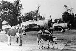
P-47 Thunderbolts, including (2N-U, serial number 42-25904) nicknamed "Lethal Liz II", of the 50th Fighter Group, with cows at Carentan Airfield (A-10), France, Summer 1944 | |||||||
 Carentan Airfield | |||||||
| Coordinates | 49°18′18″N 001°10′46″W / 49.30500°N 1.17944°W | ||||||
| Type | Military Airfield | ||||||
| Site information | |||||||
| Controlled by |
| ||||||
| Site history | |||||||
| Built by | IX Engineering Command | ||||||
| In use | June–November 1944 | ||||||
| Materials | Prefabricated Hessian Surfacing (PHS) | ||||||
| Battles/wars |
| ||||||
| Garrison information | |||||||
| Garrison |
| ||||||
| Occupants |
| ||||||
| Airfield information | |||||||
| |||||||
| One runway, 4 alert pads, 50 hardstands[1] | |||||||

Carentan Airfield is an abandoned World War II military airfield, which is located near the commune of Carentan in the Basse-Normandie region of northern France.
Located just outside Carentan, the United States Army Air Force established a temporary airfield 15 June 1944, nine days after the first Allied landings in France on D-Day and only three days after the capture of Carentan. The airfield was one of the first established in the liberated area of Normandy, being constructed by the IX Engineering Command, 826th Engineer Aviation Battalion.
History
Known as Advanced Landing Ground "A-10", the airfield consisted of a single 5000' (1500m) Prefabricated Hessian Surfacing runway aligned 08/26.
In addition, tents were erected for billeting and also for support facilities; an access road was built to the existing road infrastructure; a dump was created for supplies, ammunition, and gasoline drums, along with a drinkable water; and a minimal electrical grid for communications and station lighting was installed.[2]
The fighter planes flew support missions during the Allied invasion of Normandy, patrolling roads in front of the beachhead; strafing German military vehicles and dropping bombs on gun emplacements, anti-aircraft artillery and concentrations of German troops when spotted.
After the Americans moved east into Central France with the advancing Allied Armies, the airfield was left un-garrissoned and used for resupply and casualty evacuation. It was closed on 4 November 1944.[3]
Major units assigned
- 50th Fighter Group 20 June - 23 August 1944
- 10th (TS), 81st (2N), 313th (W3) Fighter Squadrons (P-47)[4]
- 392d Fighter Squadron (H5) 25 June - 16 August 1944 (P-38)[4]
Current use
After its closure by the Americans, the airfield was returned to farmland. Today, the Normandy Tank Museum utilities part of the original site of the old A10 Airfield of Carentan, first aerodrome re-opened since 1944. It presents tanks and planes in the museum and on the operational runway to preserve this exceptional heritage dedicated to the conquest of freedom.
There is a monument to the A-10 Airfield at the junction of D 974, ex N13 toward Carentan, with D 89, turn left towards Saint Pellerin. The monument is 400 meters left, rue de Banville.[5]
See also
References
![]() This article incorporates public domain material from the Air Force Historical Research Agency website http://www.afhra.af.mil/.
This article incorporates public domain material from the Air Force Historical Research Agency website http://www.afhra.af.mil/.
- ↑ Carentan Airfield
- ↑ IX Engineer Command ETO Airfields, Airfield Layout
- ↑ Johnson, David C. (1988), U.S. Army Air Forces Continental Airfields (ETO), D-Day to V-E Day; Research Division, USAF Historical Research Center, Maxwell AFB, Alabama.
- 1 2 Maurer, Maurer. Air Force Combat Units of World War II. Maxwell AFB, Alabama: Office of Air Force History, 1983. ISBN 0-89201-092-4.
- ↑ Carentan Airfield monument
External links
| Wikimedia Commons has media related to Carentan Airfield. |
- Normandy Tank Museum
- A-10 Memorial
- A-10 Carentan (In French)
.svg.png)