Ismailia Air Base
| Ismailia Air Base RAF Ismailia | |||||||
|---|---|---|---|---|---|---|---|
| Near: Ismailia, Egypt | |||||||
|
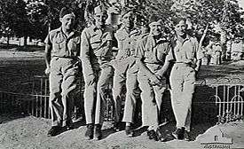
Members of No. 458 Squadron RAAF at RAF Ismailia, 1942 | |||||||
 Ismailia Air Base Air Base Location in Egypt | |||||||
| Coordinates | 30°35′53.75″N 032°14′12.86″E / 30.5982639°N 32.2369056°ECoordinates: 30°35′53.75″N 032°14′12.86″E / 30.5982639°N 32.2369056°E | ||||||
| Site information | |||||||
| Owner | Egyptian Armed Forces | ||||||
| Operator |
| ||||||
| Controlled by |
Royal Air Force (1935-1956) Ninth Air Force (1942) Egyptian Air Force (1956-Present) | ||||||
| Site history | |||||||
| Battles/wars | |||||||
| Airfield information | |||||||
| |||||||
Ismailia Air Base Air Base is an Egyptian Air Force (Arabic: القوات الجوية المصرية, El Qūwāt El Gawīyä El Maṣrīyä) base, located approximately 4 km west-northwest of Ismailia; (Al Isma`iliyah); 116 km northeast of Cairo.
History
During World War II, the airfield, then known as RAF Ismailia or Ismailia Airfield, was used as a military airfield by the British Royal Air Force and the United States Army Air Force during the North African Campaign against Axis forces. Ismailia was a pre-World War II station, originally opened about 1916.
Today, the airfield is an active Egyptian Air Force base. Its World War II configuration is still evident in aerial photography.
Major units assigned
- Royal Air Force
- No. 208 Squadron RAF 1920-1922
- No. 113 Squadron RAF Aug-Sep 1917
- No. 211 Squadron RAF Jan 1939-Nov 1940
- No. 40 Wing RAF 1919-Apr 1920
- No. 33 Squadron RAF 1938 - ?
- United States Army Air Forces (Ninth Air Force)
- 12th Bombardment Group October 1942-Undetermined (B-25 Mitchell)
- 436th Troop Carrier Group, 13 August - 18 October 1942. C-47 Skytrain
- 434th Bombardment Group, 14 August – 29 September 1942, B-25 Mitchell
- "Gladiator Ace" (2010), B. Cull, Haynes Publishing, p.20 -21.
See also
-
 Media related to RAF Ismailia at Wikimedia Commons
 - List of World War II North Africa Airfields
References
- ↑
 This article incorporates public domain material from the Air Force Historical Research Agency website http://www.afhra.af.mil/.
- Maurer, Maurer. Air Force Combat Units of World War II. Maxwell AFB, Alabama: Office of Air Force History, 1983. ISBN 0-89201-092-4.
- Maurer, Maurer, ed. (1982) [1969]. Combat Squadrons of the Air Force, World War II (PDF) (reprint ed.). Washington, DC: Office of Air Force History. ISBN 0-405-12194-6. LCCN 70605402. OCLC 72556.
External links
.svg.png)
This article is issued from Wikipedia - version of the 11/1/2016. The text is available under the Creative Commons Attribution/Share Alike but additional terms may apply for the media files.