Canhas
| Canhas | ||
| Civil Parish | ||
 The parish church and principal focus of community life, the Church of Nossa Senhora da Piedade | ||
|
||
| Official name: Freguesia dos Canhas | ||
| Country | ||
|---|---|---|
| Autonomous Region | ||
| Island | Madeira | |
| Municipality | Ponta do Sol | |
| Center | Canhas | |
| - elevation | 985 m (3,232 ft) | |
| - coordinates | 32°43′36″N 17°6′34″W / 32.72667°N 17.10944°WCoordinates: 32°43′36″N 17°6′34″W / 32.72667°N 17.10944°W | |
| Lowest point | ||
| - elevation | 0 m (0 ft) | |
| Area | 16.66 km2 (6 sq mi) | |
| Population | 3,769 (2011) | |
| Density | 226/km2 (585/sq mi) | |
| Settlement | fl.1550 | |
| - Parish | 10 July 1578 | |
| LAU | Junta Freguesia | |
| - location | Lombo da Piedade, Sítio das Murteiras | |
| President Junta | António Luís Romão da Vera Cruz (PPD-PSD) | |
| Timezone | WET (UTC0) | |
| - summer (DST) | WEST (UTC+1) | |
| Postal Zone | 9360-00 | |
| Area Code & Prefix | (+351) 291 XXX XXX | |
| Demonym | Canheiro | |
| Patron Saint | Nossa Senhora das Dores | |
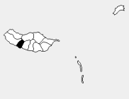 Location of the parish seat of Canhas in the municipality of Ponta do Sol, island of Madeira
| ||
| Wikimedia Commons: Canhas | ||

Canhas is a civil parish in the municipality of Ponta do Sol in the Portuguese archipelago of Madeira. Extending into the interior from the coast, the parish has an area of 16.66 km².[1] It has a population of 3,769 (2011).[2]
Economy
A once essentially agricultural parish, Canhas has gradually been converted into an important economic centre, while retaining its rural feel. Even though agriculture is still a prime industry, civil construction and related industries have conquered a prominent position in the parish.
References
- ↑ Eurostat Archived September 6, 2014, at the Wayback Machine.
- ↑ Instituto Nacional de Estatística
This article is issued from Wikipedia - version of the 11/18/2016. The text is available under the Creative Commons Attribution/Share Alike but additional terms may apply for the media files.