Canal Flats
| Canal Flats | |
|---|---|
| Village | |
| Village of Canal Flats[1] | |
|
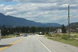
Looking north at Canal Flats on BC93 / BC95 | |
 Canal Flats Location of Canal Flats in British Columbia | |
| Coordinates: 50°09′N 115°50′W / 50.150°N 115.833°W | |
| Country |
|
| Province |
|
| Regional district | East Kootenay |
| Government | |
| • Governing body | Canal Flats Village Council |
| Area | |
| • Total | 10.86 km2 (4.19 sq mi) |
| Population (2011) | |
| • Total | 715 |
| Time zone | MST (UTC-7) |
| Highways | Highway 95 |
| Waterways | Columbia Lake, Columbia River, Kootenay River |
| Website |
www |
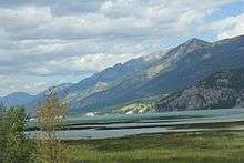
Canal Flats is a village located at the southern end of Columbia Lake, the source of the Columbia River in British Columbia, Canada. In 2006, it had a population of 700.[2]
Location
Canal Flats is on Highway 95, in the Kootenay River Valley, part of the Rocky Mountain Trench, between Skookumchuck and Fairmont Hot Springs. The population was 700 in 2006. Timber is the main industry in the village with a sawmill located in the village. Canal Flats is the gateway to several backcountry provincial parks, including Whiteswan and Top of the World, and is an entrance to the Kootenay River Road.
Canal Flats sits 1 kilometre from the southern end of the 16-kilometre long Columbia Lake, the source of the Columbia River that flows north to Kinbasket Lake before turning south to finally empty into the Pacific Ocean at Astoria, Oregon, a journey of 1,225 miles (1,960 km). Columbia Lake lies squeezed between two walls of rock; the Purcell Mountains to the west and the Rocky Mountains to the east. The Kootenay River Valley area was a major transportation corridor in pre-Contact native America and the early years of western exploration.
A low, 1.2-mile (2-km) wide berm of land called Canal Flats separates the headwaters of the Columbia, which flows north at its beginning, from the south-flowing Kootenay River. The Kootenay meanders down into the US before flowing back north into Canada to join the Columbia River at Castlegar, BC.
Canal Flats was originally named McGillivray's Portage by David Thompson, who passed through the area in 1808. Not far from the Canal Flats Provincial Park are the remains of a canal, completed in 1889, which connected Columbia Lake with the nearby Kootenay River, hence the name Canal Flats given to the post office in 1913.
Baillie-Grohman Canal
The canal was part of a scheme by English/Austrian entrepreneur William Adolf Baillie Grohman in the 1880s to breach Canal Flats and divert water from the upper Kootenay River into the Columbia system, thereby sufficiently lowering the level of Kootenay Lake to reclaim the 48,000-acre (190 km2) rich alluvial plain in the Creston area and open up a north-south navigational system from Golden to Montana. The scheme was abandoned under pressure from the Canadian Pacific Railways, concerned about its Columbia River crossings, and from settlers around Golden who feared that their farmlands would be flooded.[3]
Baillie-Grohman had to settle for building a canal and lock system between the two rivers, completed in 1889. Only two ships ever passed through the canal; in 1895 the sternwheeler Gwendoline successfully navigated the canal from the Kootenay River to the Columbia River, followed in 1902 by the North Star.[3]
The canal builder owned the first store and post office in the community as well as the first steam sawmill in the valley, the start of the lumber industry that has put Canal Flats on the map.
Canal Days Party
On the first weekend in June, Canal Flats holds their annual Canal Days Party. Events include a talent show, parades, pancake breakfast, beer garden, raffles, and naming the Canal Flats Citizen of the Year.
See also
| Wikimedia Commons has media related to Baillie-Grohman Canal. |
References
- ↑ "British Columbia Regional Districts, Municipalities, Corporate Name, Date of Incorporation and Postal Address" (XLS). British Columbia Ministry of Communities, Sport and Cultural Development. Archived from the original on July 13, 2014. Retrieved November 2, 2014.
- ↑ http://www12.statcan.gc.ca/census-recensement/2006/dp-pd/prof/92-591/details/page.cfm?Lang=E&Geo1=CSD&Code1=5901043&Geo2=PR&Code2=59&Data=Count&SearchText=Canal&SearchType=Begins&SearchPR=01&B1=All&Custom=
- 1 2 Downs, Art, Paddlewheels on the Frontier -- The Story of British Columbia and Yukon Sternwheel Steamers, at 101-113, Superior Publishing, Seattle, WA 1972
External links
| Subdivisions | 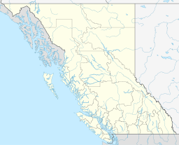 | |
|---|---|---|
| Communities | ||
| Metro areas and agglomerations | ||
| Villages |
| |
| ||