California State Route 273
| ||||
|---|---|---|---|---|
|
Map of Shasta County in northern California with SR 273 highlighted in red | ||||
| Route information | ||||
| Defined by Streets and Highways Code § 573 | ||||
| Maintained by Caltrans | ||||
| Length: | 16.23 mi[1] (26.12 km) | |||
| Major junctions | ||||
| South end: |
| |||
| North end: |
| |||
| Location | ||||
| Counties: | Shasta | |||
| Highway system | ||||
| ||||

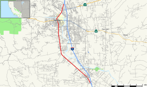
State Route 273 is a state highway in Shasta County, California, United States. The route takes a more direct approach to the cities of Anderson and Redding, passing through their downtown districts. Interstate 5 is a bypass of this route, as it connects both ends. This route was part of former U.S. Route 99.
In 2007 an effort was begun to have this segment signed as "Historic Route 99". Supporters hope to have black-and-white historical Route 99 signs up by October. They will be placed from North Market Street in Redding down to where Interstate 5 meets Highway 273 south of Anderson.
Route description
.jpg)
SR 273 begins just south of Anderson at an interchange with Interstate 5. The roadway then parallels I-5 northeast into central Anderson. Upon exiting a suburban area, the route enters farmland, while paralleling the Sacramento River. The roadway then enters suburban Redding, where it turns away from the Sacramento River and zigzags along local roads through downtown, where it meets State Route 299. Upon exiting downtown, SR 273 crosses the Sacramento River and meets its northern terminus at Interstate 5 in the suburbs of Redding.[2]
Major intersections
Except where prefixed with a letter, postmiles were measured on the road as it was in 1964, based on the alignment of U.S. Route 99 as it existed at that time, and do not necessarily reflect current mileage. R reflects a realignment in the route since then, M indicates a second realignment, L refers an overlap due to a correction or change, and T indicates postmiles classified as temporary (for a full list of prefixes, see the list of postmile definitions).[3] Segments that remain unconstructed or have been relinquished to local control may be omitted. The entire route is in Shasta County.
| Location | Postmile [3][4][5] | Destinations | Notes | ||
|---|---|---|---|---|---|
| Anderson | 3.81 | Interchange; southbound exit and northbound entrance; south end of SR 273; I-5 north exit 667A | |||
| Redding | R16.45– R16.51 | ||||
| R16.66– R16.80 | |||||
| R16.73– 16.83 | South end of SR 299 overlap | ||||
| 18.62 | North end of SR 299 overlap | ||||
| 20.03 | Interchange; northbound exit and southbound entrance; north end of SR 273; I-5 south exit 681B | ||||
1.000 mi = 1.609 km; 1.000 km = 0.621 mi
| |||||
References
- ↑ January 1, 2006 California Log of Bridges on State Highways
- ↑ Microsoft; Nokia (2010-07-21). "SR 273" (Map). Bing Maps. Microsoft. Retrieved 2010-07-21.
- 1 2 California Department of Transportation. "State Truck Route List". Sacramento: California Department of Transportation. Archived from the original (XLS file) on June 30, 2015. Retrieved June 30, 2015.
- ↑ California Department of Transportation, Log of Bridges on State Highways, April 2008
- ↑ California Department of Transportation, All Traffic Volumes on CSHS, 2007
External links
| Wikimedia Commons has media related to California State Route 273. |