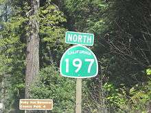
California State Route 197
| ||||
|---|---|---|---|---|
| North Bank Road | ||||
|
Map of Del Norte County in northwestern California with SR 197 highlighted in red | ||||
| Route information | ||||
| Defined by Streets and Highways Code § 497 | ||||
| Maintained by Caltrans | ||||
| Length: | 6.725 mi[1] (10.823 km) | |||
| Major junctions | ||||
| South end: |
| |||
| North end: |
| |||
| Location | ||||
| Counties: | Del Norte | |||
| Highway system | ||||
| ||||

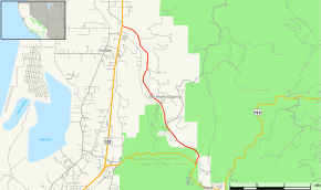
State Route 197 (SR 197) is a state highway in the U.S. state of California in Del Norte County near Crescent City. It is a bypass connecting U.S. Highways 199 and 101. It runs along the north bank of the Smith River.
Route description
SR 197 begins with an intersection at U.S. Route 199 in Jedediah Smith Redwoods State Park. Moving northward, the road quickly exits the park, roughly paralleling the Smith River located to the west side of the road. The road then follows the river northward and then northwestward with several local roads meeting SR 197 along the evergreen forest area. The road meets its northern terminus at U.S. Route 101 just south of the Oregon border.[2]
Major intersections
Except where prefixed with a letter, postmiles were measured on the road as it was in 1964, based on the alignment that existed at the time, and do not necessarily reflect current mileage. R reflects a realignment in the route since then, M indicates a second realignment, L refers an overlap due to a correction or change, and T indicates postmiles classified as temporary (for a full list of prefixes, see the list of postmile definitions).[1] Segments that remain unconstructed or have been relinquished to local control may be omitted. The entire route is in Del Norte County.
| Location | Postmile [1][3][4] | Destinations | Notes | ||
|---|---|---|---|---|---|
| | R0.00 | South end of SR 197 | |||
| | 7.08 | North end of SR 197 | |||
| 1.000 mi = 1.609 km; 1.000 km = 0.621 mi | |||||
References
- 1 2 3 California Department of Transportation. "State Truck Route List". Sacramento: California Department of Transportation. Archived from the original (XLS file) on June 30, 2015. Retrieved June 30, 2015.
- ↑ Microsoft; Nokia (2011-01-19). "SR 197" (Map). Bing Maps. Microsoft. Retrieved 2011-01-19.
- ↑ California Department of Transportation, Log of Bridges on State Highways, July 2007
- ↑ California Department of Transportation, All Traffic Volumes on CSHS, 2005 and 2006