California State Route 156
| ||||
|---|---|---|---|---|
|
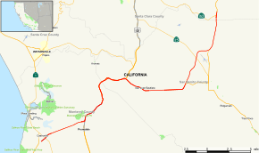
Map of western California with SR 156 highlighted in red | ||||
| Route information | ||||
| Defined by Streets and Highways Code § 456 | ||||
| Maintained by Caltrans | ||||
| Length: | 25 mi[1] (40 km) | |||
| Major junctions | ||||
| West end: |
| |||
|
| ||||
| East end: |
| |||
| Highway system | ||||
| ||||

State Route 156 is a state highway in California, USA, running from State Route 1 in Castroville to State Route 152 near Hollister. It serves as part of the primary route from the Monterey Peninsula to either the San Francisco Bay Area or the California Central Valley.
This route is eligible for the State Scenic Highway System.[2]
Route description

The western terminus is at State Route 1 in Castroville. The eastern terminus is at State Route 152 near Hollister. It overlaps U.S. Route 101 for 8 miles (13 km) between Prunedale, and San Juan Bautista. Route 156 passes through Monterey, San Benito, and Santa Clara Counties. Along with US 101, it is the quickest route from the San Francisco Bay Area to the Monterey Peninsula. In addition, SR 156's connection with SR 152 allows direct access to the California Central Valley.
For its westernmost two miles (3 km), Route 156 is a freeway through Castroville, terminating at a Y-interchange with the Route 1 freeway. There is no direct access from Route 156 West to Route 1 North or Route 1 South to Route 156 East. Motorists who want to go from Route 1 South to Route 156 East can do so by using Route 183 South through Castroville. Traffic heading west on Route 156 can access Route 1 North by exiting at the Route 183 interchange and heading north.
History
The original portion of the route was defined in 1909 and ran from U.S. Route 101 to Hollister. In 1933, the remainder of the route (between Castroville and US 101 and between Hollister and Route 152) was added. It was signed as Route 156 by 1963, but was not part of the original 1934 state signage of routes.
Route 156 was originally routed through Hollister on 4th street and turned left on San Benito Street where it shared a route with Route 25 for 1 mile (as of 2009, SR 25 was rerouted onto a bypass.) before splitting with SR 25, and meeting its current alignment at the current SR 156/ San Benito Road intersection. In 1998, Route 156 was rerouted onto a new bypass of Hollister. A stub of the original route can be seen southeast of this intersection.
Route 156 east originally came to an intersection with US 101. This intersection became dangerous because U.S. 101 traffic didn't stop. This intersection was replaced with an interchange since then. A stub of the intersection can still be seen between the southbound on ramp and the bridge crossing U.S. 101.
Future
Highway 156 experiences heavy truck traffic as it serves as a primary route for moving people and goods between the Monterey Peninsula and the rest of the state. It directly links with Highway 152, one of a small number of passable routes across the Coast Ranges between Monterey Bay and the Central Valley.
Monterey County
The westernmost segment from Highway 1 to Highway 101 in Prunedale is a heavily traveled 2-lane section that has experienced numerous fatal crashes in recent years. Environmental studies are underway to upgrade this 5-mile (8 km) section to either a 4-lane highway or fully controlled access expressway. The Transportation Agency for Monterey County and Caltrans have narrowed the list of upgrade alternatives to one freeway and one expressway option. Alternative 11 — the expressway option — will add a second carriageway to the existing road. Interchanges will be constructed at Castroville Boulevard and Cathedral Oaks Road, while Oak Hills Drive will be an at-grade intersection. Alternative 12 — the freeway option — will build a new freeway to the south of the existing roadway with an interchange at Castroville Boulevard. Under this alternative, there will be no interchange with Cathedral Oaks Road or Oak Hills Drive. The existing Route 156 would be converted to a frontage road providing access to Cathedral Oaks Road and Oak Hills Drive. The environmental studies are expected to be complete in 2009, with the project slated for completion in 2015.[3]
San Benito County
San Benito County and Caltrans are conducting environmental studies for widening Highway 156 from two to four lanes between Highway 101 near San Juan Bautista and the Santa Clara County line. Interchanges are proposed with Highway 25 northwest of Hollister, Business Route 156 both north and southwest of Hollister, and Highway 101. The entire segment may be upgraded to freeway status to eliminate delays caused by numerous traffic lights currently present in the Hollister area.
Major intersections
Except where prefixed with a letter, postmiles were measured on the road as it was in 1964, based on the alignment that existed at the time, and do not necessarily reflect current mileage. R reflects a realignment in the route since then, M indicates a second realignment, L refers an overlap due to a correction or change, and T indicates postmiles classified as temporary (for a full list of prefixes, see the list of postmile definitions).[4] Segments that remain unconstructed or have been relinquished to local control may be omitted. The numbers reset at county lines; the start and end postmiles in each county are given in the county column.
| County | Location | Postmile [4][5][6] | Exit [7] | Destinations | Notes |
|---|---|---|---|---|---|
| Monterey MON R0.17-101.32[N 1] | | R0.17 | Westbound exit and eastbound entrance; west end of SR 156 | ||
| Castroville | R1.11 | ||||
| | East end of freeway | ||||
| Prunedale | | Prunedale Road | Interchange westbound; at-grade intersection eastbound | ||
| T5.19 95.44[N 1] | Interchange; west end of US 101 overlap | ||||
| | 96.14[N 1] | 337 | San Miguel Canyon Road (CR G12) | Interchange | |
| | 98.37[N 1] | 339 | Crazy Horse Canyon Road, Echo Valley Road | Interchange | |
| | 100.39[N 1] | Dunbarton Road to San Juan Road (CR G11) – Aromas, Watsonville | Closed | ||
| San Benito SBT 0.00[N 1]-R18.43 | | 0.00[N 1] | 342 | San Juan Road (CR G11) – Aromas, Watsonville | Interchange |
| | | West end of freeway on US 101 | |||
| | | East end of freeway on US 101 | |||
| | 3.00[N 1] 0.00 | Interchange; east end of US 101 overlap | |||
| San Juan Bautista | 3.02 | West end of CR G1 overlap; former US 101 | |||
| | | East end of CR G1 overlap; former SR 156 east | |||
| | R11.37 | ||||
| | R13.22 | San Felipe Road (SR 156 Bus. west) – Hollister | Former SR 156 west | ||
| Santa Clara SCL 0.00-R0.60 | | R0.60 | Interchange; eastbound exit and westbound entrance; east end of SR 156 | ||
1.000 mi = 1.609 km; 1.000 km = 0.621 mi
| |||||
References
- ↑ January 1, 2006 California Log of Bridges on State Highways
- ↑ CA Codes (shc:260-284)
- ↑ TAMC Highway 156 Upgrades
- 1 2 California Department of Transportation. "State Truck Route List". Sacramento: California Department of Transportation. Archived from the original (XLS file) on June 30, 2015. Retrieved June 30, 2015.
- ↑ California Department of Transportation, Log of Bridges on State Highways, July 2007
- ↑ California Department of Transportation, All Traffic Volumes on CSHS, 2005 and 2006
- ↑ California Department of Transportation, California Numbered Exit Uniform System, U.S. Route 101 Freeway Interchanges, Retrieved on 2009-02-14.