California State Route 129
| ||||
|---|---|---|---|---|
 | ||||
| Route information | ||||
| Defined by Streets and Highways Code § 429 | ||||
| Maintained by Caltrans | ||||
| Length: | 14.095 mi[1] (22.684 km) | |||
| Existed: | 1964 – present | |||
| Major junctions | ||||
| West end: |
| |||
| East end: |
| |||
| Highway system | ||||
| ||||

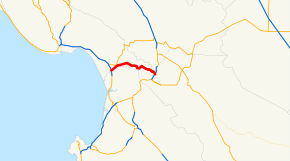
State Route 129 (SR 129) is a state highway in the U.S. state of California in Santa Cruz County. The highway connects State Route 1 in Watsonville east to U.S. Route 101.
Route description
The route begins at State Route 1 with an interchange. The road then heads northeast into the town of Watsonville along Riverside Road, where it intersects County Route G12. Heading eastward out of town, SR 129 roughly parallels the Pajaro River along the Santa Cruz-San Benito County line before entering San Benito County near Chittenden. Crossing the Pajaro River, the road runs southeast along Chittenden road to end at U.S. Route 101.[2]
Major intersections
Except where prefixed with a letter, postmiles were measured on the road as it was in 1964, based on the alignment that existed at the time, and do not necessarily reflect current mileage. R reflects a realignment in the route since then, M indicates a second realignment, L refers an overlap due to a correction or change, and T indicates postmiles classified as temporary (for a full list of prefixes, see the list of postmile definitions).[1] Segments that remain unconstructed or have been relinquished to local control may be omitted. The numbers reset at county lines; the start and end postmiles in each county are given in the county column.
| County | Location | Postmile [1][3][4] | Destinations | Notes | |
|---|---|---|---|---|---|
| Santa Cruz SCR L0.00-10.00 | | L0.00 | Interchange; west end of SR 129 | ||
| Watsonville | | ||||
| | 3.35 | Carlton Road | |||
| | 7.20 | Rogge Lane – Aromas | |||
| San Benito SBT 0.00-R2.64 | | R2.64 | Interchange; east end of SR 129 | ||
| | R2.64 | Chittenden Road | Continuation beyond US 101 | ||
| 1.000 mi = 1.609 km; 1.000 km = 0.621 mi | |||||
References
- 1 2 3 California Department of Transportation. "State Truck Route List". Sacramento: California Department of Transportation. Archived from the original (XLS file) on June 30, 2015. Retrieved June 30, 2015.
- ↑ Microsoft; Nokia (February 6, 2011). "SR 129" (Map). Bing Maps. Microsoft. Retrieved February 6, 2011.
- ↑ California Department of Transportation, Log of Bridges on State Highways, July 2007
- ↑ California Department of Transportation, All Traffic Volumes on CSHS Archived July 21, 2011, at the Wayback Machine., 2006