California State Route 11
| ||||
|---|---|---|---|---|
|
SR 11 highlighted in red | ||||
| Route information | ||||
| Maintained by Caltrans | ||||
| Length: | 1.7 mi[1] (2.7 km) | |||
| Existed: | 1994[2] – present | |||
| Major junctions | ||||
| West end: |
| |||
| East end: | Enrico Fermi Drive in Otay Mesa | |||
| Location | ||||
| Counties: | San Diego | |||
| Highway system | ||||
| ||||
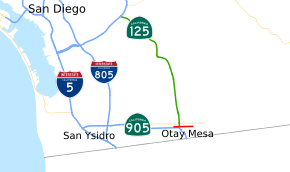
State Route 11 (SR 11) is a state route in San Diego County that is planned to connect SR 905 and SR 125 with the proposed new U.S.–Mexico border crossing at Otay Mesa East. Planning for the road began in the 1990s, and construction started in 2013. As of 2016, the portion from SR 905 to Enrico Fermi Drive is complete, with the rest of the road scheduled for completion in 2017.
Route description
SR 11 is proposed to be a toll facility that will serve a new border crossing east of Otay Mesa,[3] the Otay Mesa East Port of Entry. It will connect SR 905 and SR 125 to the Corredor Tijuana-Rosarito 2000 corridor that connects to Mexican Federal Highway 2D and Mexican Federal Highway 2 to Tecate, and Mexican Federal Highway 1D to Ensenada.[4]
As of 2016, the portion from SR 905 to Enrico Fermi Drive is completed.[1] On that segment, plans were to construct two interchanges at Enrico Fermi Drive and Siempre Viva Road as the proposed route curves to the southeast before reaching the border crossing.[5] SR 11 will operate as a toll road once the entire route is completed.[1]
History
SR 11 was added to the state highway system in 1994.[2] Four years later, several parties, including District 11 of Caltrans, the City and County of San Diego, the San Diego Association of Governments, and Tijuana were signatories to a Letter of Intent to build the border crossing.[6] The route was added to the California Freeway and Expressway System in 1999.[7] In 2009, Senate Bill 1486 was passed, and the presidential permit in 2008 allowed for the border crossing to be constructed. By one year later, several alternatives were considered, in terms of constructing some or even none of the interchanges, or removing the proposed toll on the route.[4] State funding is allocated to cover much of the $400 million cost, which does not include the port of entry at another $350 million. The California Transportation Commission endorsed the project in January 2012,[5] and approved the proposed freeway route that December.[6]
Plans are to construct the road in three stages: the interchange with SR 905 and the road to Enrico Fermi Drive, continuing the construction to the commercial vehicle facility, and building the border crossing itself.[5] The first part of construction—connecting to SR 905—started on December 10, 2013 and was completed on March 19, 2016. The entire road is scheduled for completion by 2017. Tolls are planned for the road in order to keep delays for crossing the border low, and this would vary depending on the current traffic at the other crossings in the area. The funds would go to both countries.[1][8][9]
Exit list
The entire route is in San Diego, San Diego County.
| mi[10] | km | Exit[10] | Destinations | Notes | |
|---|---|---|---|---|---|
| 0.00 | 0.00 | Westbound exit and eastbound entrance; west end of SR 11; future I-905 | |||
| 0.32 | 0.51 | 1A | La Media Road | Westbound exit and eastbound entrance | |
| 0.40– 0.58 | 0.64– 0.93 | 1 | Will be signed as exit 1A eastbound and 1B westbound | ||
| 1.40 | 2.25 | 1B | Enrico Fermi Drive | Eastbound exit and westbound entrance; current east end of SR 11 | |
| Siempre Viva Road | Proposed interchange[5] | ||||
| Mexico – United States border[5] | |||||
1.000 mi = 1.609 km; 1.000 km = 0.621 mi
| |||||
See also
 California Roads portal
References
- 1 2 3 4 "1st Segment of SR-11 Opens Along Border". 10 News. March 19, 2016. Archived from the original on March 19, 2016. Retrieved March 19, 2016.
- 1 2 California State Assembly. "An act to amend Section 2982.2 of, and to add Section 3068.2 to, the Civil Code, to amend Sections 40084.5, 40088, and 40089 of the Education Code, to amend Section 29601 of, to amend and renumber Section 14035.6 of, to...". 1993–1994 Session of the Legislature. Statutes of California. State of California. Ch. 1220.
- ↑ Hawkins, Robert (January 11, 2011). "Hearing Set on Border Highway and Crossing". San Diego Union-Tribune. p. B2.
- 1 2 Sturmer, Kim (December 2010). "State Route-11 Transportation Concept Summary" (PDF). California Department of Transportation. Retrieved September 9, 2013.
- 1 2 3 4 5 California Department of Transportation (August 2013). "SR 11/Otay Mesa East Port of Entry Fact Sheet" (PDF) (in Spanish). California Department of Transportation. Archived from the original (PDF) on November 27, 2013. Retrieved September 9, 2013.
- 1 2 California Transportation Commission (December 6, 2012). "Estimated Timed Agenda" (PDF). pp. 249–251. Retrieved July 2, 2015.
"Minutes" (PDF). California Transportation Commission. December 6, 2015. Retrieved July 2, 2015. - ↑ California State Assembly. "An act to amend Sections 14076.2 and 103113 of, and to repeal Section 14451 of, the Government Code, to amend Section 20300 of, and to amend the heading of Article 16 (commencing with Section 20300) of Chapter 1 of Part 3...". 1999–2000 Session of the Legislature. Statutes of California. State of California. Ch. 724.
- ↑ Dibble, Sandra (December 11, 2013). "New Border Crossing Plan Takes First Step". U-T San Diego. p. B1.
"Corrections". U-T San Diego. December 12, 2013. p. A2. - ↑ "Toll Proposed at Otay East". U-T San Diego. February 1, 2015. p. SD3.
- 1 2 Reynoso, S.; Howe, D. "State Route 11 Freeway Interchanges" (PDF). California Numbered Exit Uniform System. Sacramento: California Department of Transportation. Retrieved July 9, 2012.